File:Monterey CA papercut.jpg
Jump to navigation
Jump to search


Size of this preview: 800 × 532 pixels. Other resolutions: 320 × 213 pixels | 640 × 426 pixels | 1,000 × 665 pixels.
Original file (1,000 × 665 pixels, file size: 521 KB, MIME type: image/jpeg)
Summary
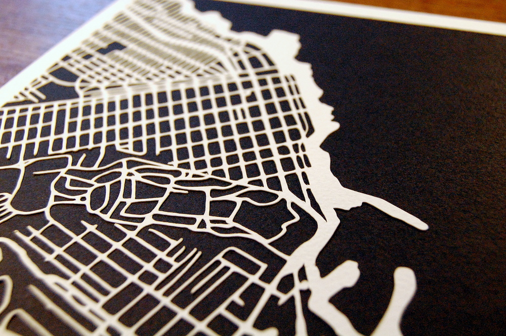
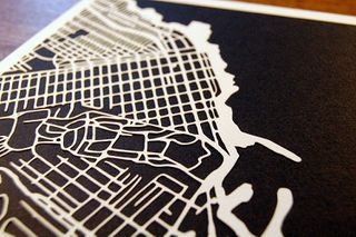
Kartegraphik has been doing handmade papercut maps based on OpenStreetMap data. The image presents the map of Monterey, California. See more at http://www.kartegraphik.com
This is a Featured image, which means that it has been identified as one of the best examples of OpenStreetMap mapping, or that it provides a useful illustration of the OpenStreetMap project. If you know another image of similar quality, you can nominate it on Featured image proposals.
Front-page image for week 18 of 2017 (1–7 May).
- Image descriptions
- Deutsch : Kartegraphik hat handgemachte Papierschnittkarten aus OpenStreetMap-Daten erstellt. Dieses Bild zeigt eine Karte von Monterey in Kalifornien. Mehr dazu unter kartegraphik.com.
- English : Kartegraphik has been doing handmade papercut maps based on OpenStreetMap data. This image is a map of Monterey, California. See more at kartegraphik.com.
- français : Kartegraphik a réalisé des découpages papier faits à la main d’après les données OpenStreetMap. Cette image est une carte de Monterey en Californie. En voir d’autres sur kartegraphik.com.
- italiano : Kartegraphik realizza a mano delle mappe basate sui dati di OpenStreetMap ritagliando la carta. Questa immagine è una mappa di Monterey, in California. Ulteriori informazioni all'indirizzo kartegraphik.com.
- 中文(简体) : Kartegraphik 运用开放街图资料制作手工剪纸地图,这张图片是加州蒙特雷的地图。kartegraphik.com 阅读更多资讯。
- 中文(繁體) : Kartegraphik 運用開放街圖資料製作手工剪紙地圖,這張圖片是加州蒙特雷的地圖。kartegraphik.com 閱讀更多資訊。
Licensing
![]()
![]()
![]()
This work is licensed under the Creative Commons Attribution-ShareAlike 3.0 License.
Attribution not specified as a parameter! THIS LICENSE ALWAYS REQUIRES ATTRIBUTION! Use {{CC-BY-SA-3.0|Attribution, typically name of author}} See Template:CC-BY-SA-3.0 for full description how this template should be used.
Attribution not specified as a parameter! THIS LICENSE ALWAYS REQUIRES ATTRIBUTION! Use {{CC-BY-SA-3.0|Attribution, typically name of author}} See Template:CC-BY-SA-3.0 for full description how this template should be used.
File history
Click on a date/time to view the file as it appeared at that time.
| Date/Time | Thumbnail | Dimensions | User | Comment | |
|---|---|---|---|---|---|
| current | 12:35, 24 April 2017 | | 1,000 × 665 (521 KB) | Wille (talk | contribs) | Kartegraphik has been doing handmade papercut maps based on OpenStreetMap data. The image presents the map of Monterey, California. See more at http://www.kartegraphik.com |
You cannot overwrite this file.
File usage
The following 15 pages use this file:
- Featured images/Apr-Jun 2017
- List of featured images/2017
- Pt:Featured images/Apr-Jun 2017
- Uk:Featured images/Apr-Jun 2017
- Zh-hans:Featured images/Apr-Jun 2017
- Zh-hant:Featured images/Apr-Jun 2017
- File:Monterey,CA-papercut.JPG (file redirect)
- Template:Featured image d2
- Template:Iotw image/2017-18
- DE:Featured images/Apr-Jun 2017
- FR:Featured images/Apr-Jun 2017
- ES:Imágenes destacadas/Abr-Jun 2017
- IT:Featured images/Apr-Jun 2017
- RU:Featured images/Apr-Jun 2017
- JA:Featured images/Apr-Jun 2017