File:Multilingual-india-map.gif
Jump to navigation
Jump to search


No higher resolution available.
Multilingual-india-map.gif (785 × 492 pixels, file size: 614 KB, MIME type: image/gif, looped, 8 frames, 8.0 s)
Summary
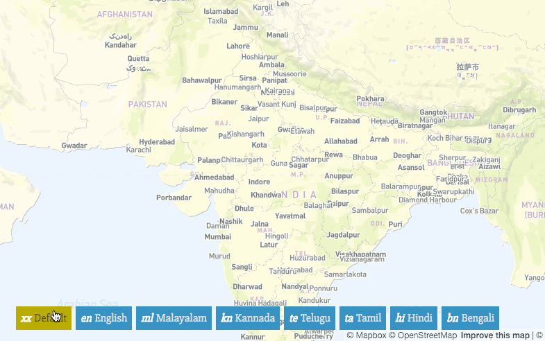
Screencast of showing navigating languages of the multingual maps of India (http://openstreetmap.in/demo.html#3.9/23.10/81.00) by user PlaneMad. Read more on his diary
This is a Featured image, which means that it has been identified as one of the best examples of OpenStreetMap mapping, or that it provides a useful illustration of the OpenStreetMap project. If you know another image of similar quality, you can nominate it on Featured image proposals.
Front-page image for week 15 of 2016 (11–17 Apr.).
- Image descriptions
- English : India has 22 languages and one of the powerful features of OpenStreetMap is that we can map places and feature names in more than one language. User PlaneMad has created a view of this data. A multilingual map of India. Read more on his diary entry.
- italiano : L'India ha 22 lingue e uno dei punti di forza di OpenStreetMap è che possiamo mappare i nomi dei luoghi e dei punti d'interesse in più di una lingua. L'utente PlaneMad ha creato una visualizzazione per questi dati: una mappa multilingue dell'India. Maggiori informazioni nella sua pagina di diario.
- русский : В Индии 22 официальных языка. Это не проблема для ОСМа, ведь структура данных поддерживает любое количество переводов. Участник PlaneMad сделал разноязычную карту Индии, где названия городов меняются по выбору пользователя. Подробности — в его блоге.
- 中文(简体) : 印度有22种语言,开放街图最强大的功能之一就是我们能用多于一种语言的方式标注地名,使用者PlaneMad制作了这张.html#3.9/23.10/81.00 印度多语言地图,呈现多语言的资料视角。各位可以到他的日记项目阅读更多详情。
- 中文(繁體) : 印度有22種語言,開放街圖最強大的功能之一就是我們能用多於一種語言的方式標注地名,使用者PlaneMad製作了這張印度多語言地圖,呈現多語言的資料視角。各位可以到他的日記項目閱讀更多詳情。
Licensing
| Contains map data © OpenStreetMap contributors, made available under the terms of the Open Database License (ODbL).
The ODbL does not require any particular license for maps produced from ODbL data, produced maps may be subject also to other licences. |
File history
Click on a date/time to view the file as it appeared at that time.
| Date/Time | Thumbnail | Dimensions | User | Comment | |
|---|---|---|---|---|---|
| current | 03:49, 24 March 2016 | | 785 × 492 (614 KB) | Harry Wood (talk | contribs) | delete lots of frames (for mouse movements) to allow the wiki to resize it |
| 12:39, 21 March 2016 | 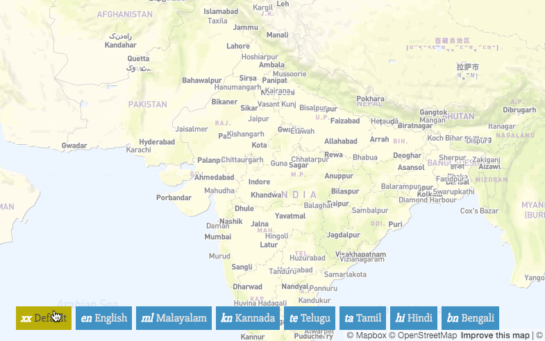 | 785 × 492 (797 KB) | Wille (talk | contribs) | Image by user PlaneMad |
You cannot overwrite this file.
File usage
The following 12 pages use this file:
- Featured images/Apr-Jun 2016
- Ko:지도 다국어화
- List of featured images/2016
- Map internationalization
- Map internationalization (India)
- Uk:Інтернаціоналізація мапи
- Template:Iotw image/2016-15
- DE:Featured images/Apr-Jun 2016
- FR:Featured images/Apr-Jun 2016
- ES:Featured images/Apr-Jun 2016
- IT:Featured images/Apr-Jun 2016
- JA:地図の多国語化