File:North London cake diagram.png
Jump to navigation
Jump to search

Size of this preview: 461 × 599 pixels. Other resolutions: 185 × 240 pixels | 534 × 694 pixels.
Original file (534 × 694 pixels, file size: 481 KB, MIME type: image/png)
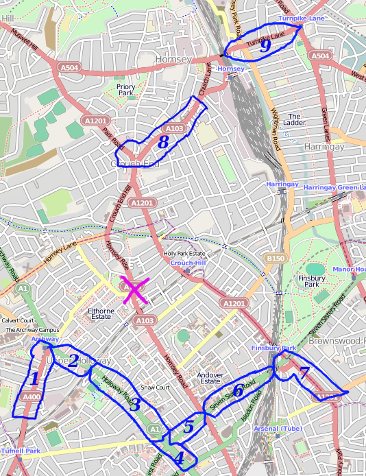
cake diagram for London/Summer 2010 mapping parties North London BBQ meat-up. 31st July 2010
Attendees
- Mappers
- Derick Rethans Slice 1!
- LastGrape/Gregory - If nobody else is mapping then I'll have to do slices 7, 6, 5, 4, 3, 2, 8, 9, and off-cake (between Finsbury Park and Harry's via Crouch Hill).
- Other lazy ones
- Harry Wood - just BBQ
- User:Smsm1 - not mapping - baking's more fun and doesn't add to the backlog (though doesn't help reduce it either).
- You can much the backlog while it bakes.
- User:Firefishy
- User:TomH
others who didn't sign up here
File history
Click on a date/time to view the file as it appeared at that time.
| Date/Time | Thumbnail | Dimensions | User | Comment | |
|---|---|---|---|---|---|
| current | 23:28, 22 July 2010 | | 534 × 694 (481 KB) | Harry Wood (talk | contribs) | cake diagram for London/Summer 2010 mapping parties North London BBQ meat-up |
You cannot overwrite this file.
File usage
There are no pages that use this file.