File:OSMLanduse.png
Jump to navigation
Jump to search


Size of this preview: 800 × 452 pixels. Other resolutions: 320 × 181 pixels | 640 × 361 pixels | 889 × 502 pixels.
Original file (889 × 502 pixels, file size: 565 KB, MIME type: image/png)
Summary
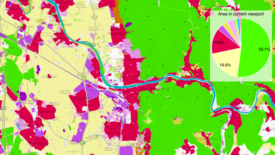
Screenshot of osmlanduse.org centred on Heidelberg.
This is a Featured image, which means that it has been identified as one of the best examples of OpenStreetMap mapping, or that it provides a useful illustration of the OpenStreetMap project. If you know another image of similar quality, you can nominate it on Featured image proposals.
Front-page image for week 7 of 2017 (13–19 Feb.).
- Image descriptions
- Deutsch : OSMLanduse.org hebt die reichhaltigen landuse/landcover-Daten von OpenStreetMap hervor. Die bemerkenswert farbige Karte demonstriert, wie unsere Vielfalt an Landcover-Tags grob klassifiziert und analysiert werden kann.
- English : OSMLanduse.org highlights OpenStreetMap's rich landuse/landcover data. The strikingly colourful map shows how our wide range of landcover tags can be broadly classified and analysed.
- italiano : OSMLanduse.org mette in luce la ricchezza dei dati di OpenStreetMap relativi a landuse/landcover. La mappa a colori vivaci mostra come la nostra ampia gamma di tag landcover può essere largamente classificata ed analizzata.
- 한국어 : OSMLanduse.org는 오픈스트리트맵의 풍부한 토지 이용/토지 덮기 자료를 밝게 표시합니다. 두드러지게 다채로운 지도는 어떻게 우리의 피복덮기 태그를 대략 분류하고 분석할 수 있는지를 보여줍니다.
- 中文(简体) : OSMLanduse.org突显显示开放街图里丰富的土地利用/植被资料。这张令人印象深的地图显示数量众多的植被标签可以广范被分类和分析。
- 中文(繁體) : OSMLanduse.org突顯顯示開放街圖裡豐富的土地利用/植被資料。這張令人印象深的地圖顯示數量眾多的植被標籤可以廣範被分類和分析。
Licensing
![]()
![]()
![]()
This work is licensed under the Creative Commons Attribution-ShareAlike 2.0 License.
Attribution not specified as a parameter! THIS LICENSE ALWAYS REQUIRES ATTRIBUTION! Use {{CC-BY-SA-2.0|Attribution, typically name of author}} See Template:CC-BY-SA-2.0 for full description how this template should be used.
Note, there is
There is also
Attribution not specified as a parameter! THIS LICENSE ALWAYS REQUIRES ATTRIBUTION! Use {{CC-BY-SA-2.0|Attribution, typically name of author}} See Template:CC-BY-SA-2.0 for full description how this template should be used.
Note, there is
{{CC-BY-SA-2.0 OpenStreetMap}} for files based on old OSM map data, before the license change made on 2012-09-12.There is also
{{OSM Carto screenshot||old_license}} for files based on old OSM map data, before the license change made on 2012-09-12, created using OSM Carto map style.
(by permission Alexander Zipf)
File history
Click on a date/time to view the file as it appeared at that time.
| Date/Time | Thumbnail | Dimensions | User | Comment | |
|---|---|---|---|---|---|
| current | 12:55, 13 February 2017 | | 889 × 502 (565 KB) | Harry Wood (talk | contribs) | screenshot of [http://osmlanduse.org/#12/8.68641/49.42102/0/ osmlanduse.org] |
You cannot overwrite this file.
File usage
The following 13 pages use this file:
- Featured images/Jan-Mar 2017
- List of featured images/2017
- Pt:Featured images/Jan-Mar 2017
- Uk:Featured images/Jan-Mar 2017
- Zh-hans:Featured images/Jan-Mar 2017
- Zh-hant:Featured images/Jan-Mar 2017
- Template:Iotw image/2017-7
- DE:Featured images/Jan-Mar 2017
- FR:Featured images/Jan-Mar 2017
- ES:Imágenes destacadas/Ene-Mar 2017
- IT:Featured images/Jan-Mar 2017
- RU:Featured images/Jan-Mar 2017
- JA:Featured images/Jan-Mar 2017