File:OSM vs OS trig stations histogram.pdf
Jump to navigation
Jump to search

Size of this JPG preview of this PDF file: 800 × 563 pixels. Other resolutions: 320 × 225 pixels | 640 × 450 pixels | 1,024 × 721 pixels | 1,239 × 872 pixels.
Original file (1,239 × 872 pixels, file size: 5 KB, MIME type: application/pdf)
Summary
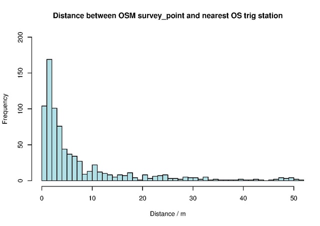
Histogram showing distance between OSM man_made=survey_points and nearest OS triangulation stations as of August 2016
Produced using R
© OpenStreetMap contributors
Contains public sector information licensed under the Open Government Licence v3.0
Licensing

The copyright holder of this file allows anyone to use it for any purpose, provided that the copyright holder is properly attributed. Redistribution, derivative work, commercial use, and all other use is permitted.
If you are the uploader, please provide proper attribution including source and name of author.
If you are the uploader, please provide proper attribution including source and name of author.
File history
Click on a date/time to view the file as it appeared at that time.
| Date/Time | Thumbnail | Dimensions | User | Comment | |
|---|---|---|---|---|---|
| current | 12:26, 30 August 2016 |  | 1,239 × 872 (5 KB) | Gregrs (talk | contribs) | Histogram showing distance between OSM man_made=survey_points and nearest OS triangulation stations as of August 2016 Produced using [https://www.r-project.org/ R] © OpenStreetMap contributors<br> Contains public sector information licensed under th... |
You cannot overwrite this file.
File usage
The following page uses this file: