File:Osm bbz sab.jpg
Jump to navigation
Jump to search


Size of this preview: 800 × 500 pixels. Other resolutions: 320 × 200 pixels | 640 × 400 pixels | 1,024 × 640 pixels | 1,600 × 1,000 pixels.
Original file (1,600 × 1,000 pixels, file size: 807 KB, MIME type: image/jpeg)
Summary
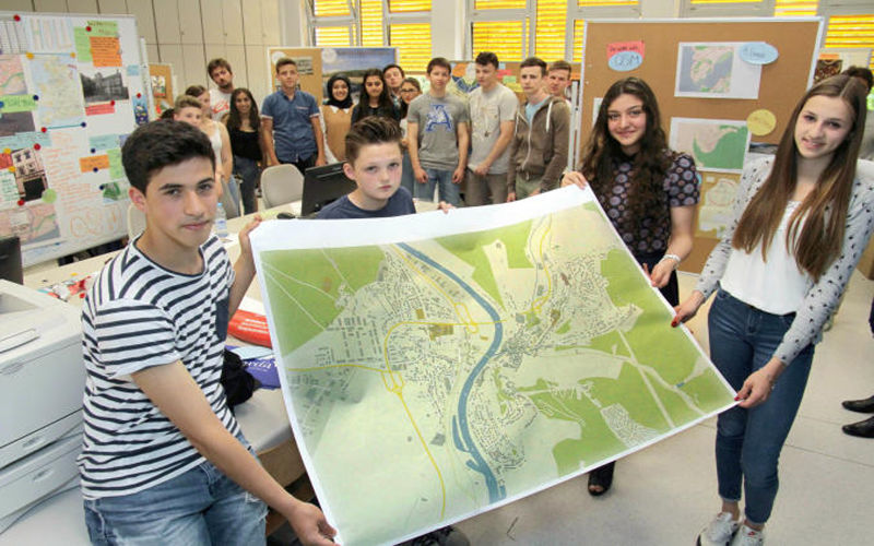
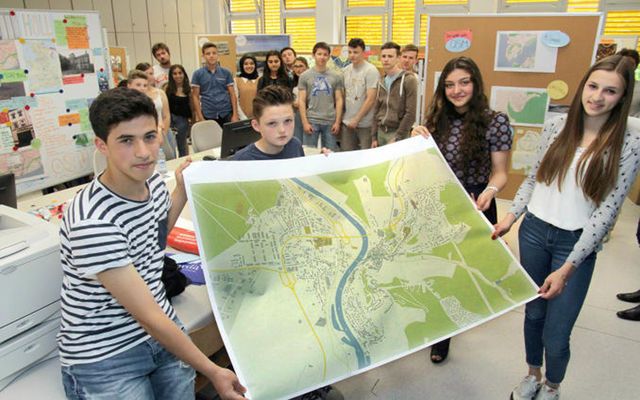
Students showing an A0 print of OpenStreetMap printed with Mapwebbing from Lars Lingner. The students from four countries came toghether in a Comenius school project MychOSM doing armchair mapping for HOT, field research on historical and geographical sites to map later with local knowledge.
Left to Right: Alejandro Lomba-Cruces, Spain; Owen Waters, England; Rabia Alkan, Turkey und Louisa Kinn from Germany
This is a Featured image, which means that it has been identified as one of the best examples of OpenStreetMap mapping, or that it provides a useful illustration of the OpenStreetMap project. If you know another image of similar quality, you can nominate it on Featured image proposals.
Front-page image for week 26 of 2015 (22–28 Jun.).
- Image descriptions
- asturianu : Estudiantes de cuatro naciones aconceyaron nel ámbitu del proyeutu escolar Comenius, MychOSM, pa preparar una investigación de campu sobro llugares históricos y xeográficos. Esta impresión en formatu A0 d'OpenStreetMap ta fecha usando Mapwebbing.
- Deutsch : Schüler aus vier Ländern sind in Saarburg im Rahmen des Comenius Schulprojektes MychOSM zusammen gekommen um historische und geografische Daten für OSM zu erfassen. Der A0 Ausdruck von OpenStreetMap wurde mit Mapwebbing von Lars Lingner erstellt.
- English : Students from four countries came together for a Comenius school project MychOSM preparing field research on historical and geographical sites. This A0 print of OpenStreetMap was made using Mapwebbing
- italiano : Studenti da quattro nazioni si sono incontrati nell'ambito di un progetto scolastico Comenius, MychOSM, preparando una ricerca sul campo su siti storici e geografici. Questa stampa in formato A0 di OpenStreetMap è stata fatta usando Mapwebbing.
- русский : Ученики из четырёх стран приняли участие в проекте МикхОСМ, который организовало сообщество «Комениус». Целью проекта было географическое исследование исторической местности. Финальную распечатку карты на листе А0 ребята создали при помощи сервиса Мапвеббинг.
- 中文(简体) : 来自四个不同国家的学生一起参与Comenius school的专案org/wiki/MychOSM MychOSM,实地调查历史与地理意义的地点。这张A0大小的开放街图地图是用Mapwebbing制作的。
- 中文(繁體) : 來自四個不同國家的學生一起參與Comenius school的專案MychOSM,實地調查歷史與地理意義的地點。這張A0大小的開放街圖地圖是用Mapwebbing製作的。
Licensing
Puplic Domain
File history
Click on a date/time to view the file as it appeared at that time.
| Date/Time | Thumbnail | Dimensions | User | Comment | |
|---|---|---|---|---|---|
| current | 12:29, 17 June 2015 | | 1,600 × 1,000 (807 KB) | Fredao (talk | contribs) |
You cannot overwrite this file.
File usage
The following 8 pages use this file: