File:Overpass turbo export example 1.png
Jump to navigation
Jump to search


Size of this preview: 648 × 600 pixels. Other resolutions: 259 × 240 pixels | 518 × 480 pixels | 972 × 900 pixels.
Original file (972 × 900 pixels, file size: 1.05 MB, MIME type: image/png)
Summary
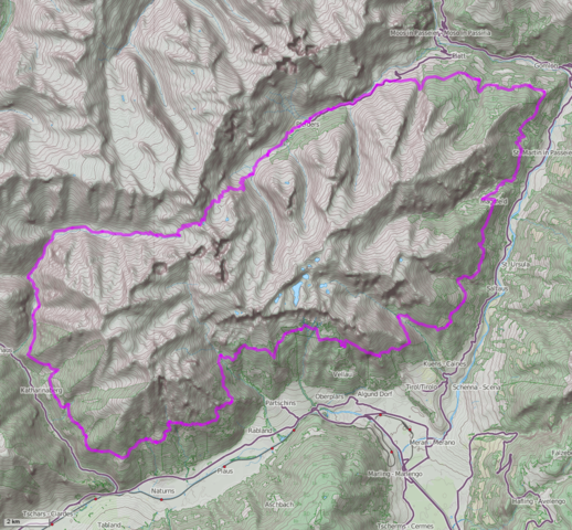
Example of the "as png image" export of overpass turbo.
Shown is the hiking route "Meraner Höhenweg". The following Overpass API query was used to produce this image (try it yourself in turbo):
<osm-script output="json">
  <query type="relation" into="hr">
    <has-kv k="route" v="hiking"/>
    <has-kv k="name:de" v="24 Meraner Höhenweg"/>
  </query>
  <union>
    <item set="hr"/>
    <recurse from="hr" type="relation-way" into="hrp"/>
    <recurse from="hr" type="relation-node"/>
  </union>
  <print mode="body" order="quadtile"/>
  <recurse from="hrp" type="way-node"/>
  <print mode="skeleton" order="quadtile"/>
</osm-script>
Licensing
Data © OpenStreetMap contributors, ODbL (Terms)
| Contains map data © OpenStreetMap contributors, made available under the terms of the Open Database License (ODbL).
The ODbL does not require any particular license for maps produced from ODbL data, produced maps may be subject also to other licences. |
Map tiles © Andy Allan (www.thunderforest.com), CC-BY-SA 2.0
![]()
![]()
![]()
This work is licensed under the Creative Commons Attribution-ShareAlike 2.0 License.
Attribution: Andy Allan (www.thunderforest.com)
Attribution: Andy Allan (www.thunderforest.com)
File history
Click on a date/time to view the file as it appeared at that time.
| Date/Time | Thumbnail | Dimensions | User | Comment | |
|---|---|---|---|---|---|
| current | 12:58, 11 January 2013 | | 972 × 900 (1.05 MB) | Tyr (talk | contribs) | Example of the "as png image" export of overpass turbo. Data © OpenStreetMap contributors, ODbL Map tiles © Andy Allan (www.thunderforest.com), CC-BY-SA 2.0 |
You cannot overwrite this file.
File usage
The following file is a duplicate of this file (more details):
- File:Übersichtskarte des Meraner Höhenwegs.png from Wikimedia Commons
The following 13 pages use this file: