File:Overpass turbo map controlls.png
Jump to navigation
Jump to search

No higher resolution available.
Overpass_turbo_map_controlls.png (266 × 208 pixels, file size: 13 KB, MIME type: image/png)
Summary
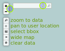
overpass turbo map controls with annotations.
(1) - zoom controls
(2) - search box (uses nominatim geocoder)
Licensing
![]()
![]()
![]()
This work is licensed under the Creative Commons Attribution-ShareAlike 2.0 License.
Attribution not specified as a parameter! THIS LICENSE ALWAYS REQUIRES ATTRIBUTION! Use {{CC-BY-SA-2.0|Attribution, typically name of author}} See Template:CC-BY-SA-2.0 for full description how this template should be used.
Note, there is
There is also
Attribution not specified as a parameter! THIS LICENSE ALWAYS REQUIRES ATTRIBUTION! Use {{CC-BY-SA-2.0|Attribution, typically name of author}} See Template:CC-BY-SA-2.0 for full description how this template should be used.
Note, there is
{{CC-BY-SA-2.0 OpenStreetMap}} for files based on old OSM map data, before the license change made on 2012-09-12.There is also
{{OSM Carto screenshot||old_license}} for files based on old OSM map data, before the license change made on 2012-09-12, created using OSM Carto map style.
File history
Click on a date/time to view the file as it appeared at that time.
| Date/Time | Thumbnail | Dimensions | User | Comment | |
|---|---|---|---|---|---|
| current | 23:32, 3 February 2013 | | 266 × 208 (13 KB) | Tyr (talk | contribs) | Reverted to version as of 23:29, 3 February 2013 |
| 23:31, 3 February 2013 |  | 266 × 208 (13 KB) | Tyr (talk | contribs) | oops | |
| 23:29, 3 February 2013 |  | 266 × 208 (13 KB) | Tyr (talk | contribs) | new control "wide map" | |
| 09:26, 29 January 2013 | 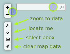 | 226 × 176 (12 KB) | Tyr (talk | contribs) | overpass turbo map controls with annotations.<br/> (1) - zoom controls<br/> (2) - search box (uses nominatim geocoder)<br/> |
You cannot overwrite this file.
File usage
The following 8 pages use this file: