File:PakistanFlood2.png
Jump to navigation
Jump to search

Size of this preview: 387 × 599 pixels. Other resolutions: 155 × 240 pixels | 452 × 700 pixels.
Original file (452 × 700 pixels, file size: 503 KB, MIME type: image/png)
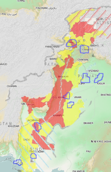
new mapping coordination image to update my original one (File:Pakistanflood.png). This now shows affected areas further South.
Red and Yellow areas are "moderate" and "severe" affected regions of this releifweb map: http://www.reliefweb.int/rw/rwb.nsf/db900sid/LYLN-88DRPJ?OpenDocument&rc=3&emid=FL-2010-000141-PAK This image composed of a badly warped screengrab from that PDF, with some details removed...
overlayed on the OpenCycleMap terrain view here
...with yahoo imagery coverage relation on top.
File history
Click on a date/time to view the file as it appeared at that time.
| Date/Time | Thumbnail | Dimensions | User | Comment | |
|---|---|---|---|---|---|
| current | 16:18, 17 August 2010 | | 452 × 700 (503 KB) | Harry Wood (talk | contribs) | new mapping coordination image showing releifweb affected areas further South |
You cannot overwrite this file.
File usage
The following 2 pages use this file: