File:Pakistanflood.png

Original file (800 × 1,149 pixels, file size: 1.16 MB, MIME type: image/png)
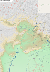
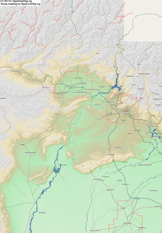
Image showing 2010 07 Pakistan Floods area (though possibly missing some affected areas to the South and West)
This is terrain renderings by OpenCycleMap here with osmarender OSM data rendering rather crudely slapped on top using photoshop.
The pink lines illustrate missing rivers in the North, which we can easily trace in from Yahoo low res (Landsat) imagery.
And also areas covered by hi-res Yahoo imagery See Pakistan yahoo imagery relation. Plenty of tracing we can do there, however this imagery is pre-floods.
![]()
Files without licences marked with this template are listed in Category:Media without a license or one of its subcategories. If the file is without a known open licence: ask its uploader to clarify situation or find a replacement and mark this file with {{Superseded by Commons}} and replace its uses.
If uploader was notified this month: use {{No licence|subcategory=uploader notified 2024, April}} - to put media into Category:Media without a license - uploader notified 2024, April and mark image as one where uploader was notified.
![]()
File history
Click on a date/time to view the file as it appeared at that time.
| Date/Time | Thumbnail | Dimensions | User | Comment | |
|---|---|---|---|---|---|
| current | 00:39, 5 August 2010 | | 800 × 1,149 (1.16 MB) | Harry Wood (talk | contribs) | Image showing 2010 07 Pakistan Floods area (though possibly missing some affected areas to the South and West) This is terrain renderings by OpenCycleMap with osmarender OSM data rendering rather crudely slapped on top using photoshop. The pink |
You cannot overwrite this file.
File usage
There are no pages that use this file.