File:Pohorje Contours.jpg
Jump to navigation
Jump to search


Size of this preview: 800 × 494 pixels. Other resolutions: 320 × 197 pixels | 640 × 395 pixels | 1,024 × 632 pixels | 1,274 × 786 pixels.
Original file (1,274 × 786 pixels, file size: 569 KB, MIME type: image/jpeg)
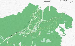
An example of using Osmarender to render OSM data together with the elevation contours generated by the [Srtm2Osm] tool.
![]()
Contains map data © OpenStreetMap contributors, made available under the terms of the Creative Commons Attribution-ShareAlike 2.0 (CC-BY-SA-2.0).
File history
Click on a date/time to view the file as it appeared at that time.
| Date/Time | Thumbnail | Dimensions | User | Comment | |
|---|---|---|---|---|---|
| current | 19:19, 14 October 2007 | | 1,274 × 786 (569 KB) | Breki (talk | contribs) | An example of using Osmarender to render OSM data together with the elevation contours generated by the [Srtm2Osm] tool. |
You cannot overwrite this file.
File usage
The following page uses this file: