File:Red Cross Cape Town Getting a GPS fix.jpg
Jump to navigation
Jump to search


Size of this preview: 337 × 599 pixels. Other resolutions: 135 × 240 pixels | 576 × 1,024 pixels.
Original file (576 × 1,024 pixels, file size: 116 KB, MIME type: image/jpeg)
Summary
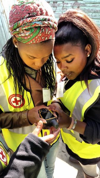
Volunteers verifying their position. The American Red Cross recently ran a community mapping exercise in Khayelitsha, a large township in Cape Town, South Africa. Read more on this diary entry including ways you can help with the ongoing mapping work
This is a Featured image, which means that it has been identified as one of the best examples of OpenStreetMap mapping, or that it provides a useful illustration of the OpenStreetMap project. If you know another image of similar quality, you can nominate it on Featured image proposals.
Front-page image for week 36 of 2015 (31 Aug. – 6 Sep.).
- Image descriptions
- English : OpenStreetMap building data in New York, New York. This was initially imported from NYC government datasets and has since been refined manually, to give more detailed shapes to many skyscrapers (ongoing). Viewed here with OSG-Maps the 3D data also looks great on osmbuildings.org, on F4 Map, and other 3D#Viewing software
- français : Données de bâtiments d'OpenStreetMap à New York, New York. Elles sont été initialement importées des jeux de données du gouvernement de la ville de New-York et ont été affinées manuellement, afin de donner des formes plus détaillées à différents grattes-ciels. Visualisé ici avec OSG-Maps. Les données 3D sont également bien rendues avec osmbuildings.org, avec F4 Map, et d'autres logiciels de visualisation 3D.
- italiano : Dati degli edifici di New York, New York in OpenStreetMap. Sono stati inizialmente importati dai dataset ufficiali e in seguito rifniti manualmente per dare forme più dettagliate a molti grattacieli (lavoro ancora in corso). Visualizzati qui con OSG-Maps, i dati in 3D sono anche fantastici su osmbuildings.org, su F4 Map, e altro software per visualizzazione 3D.
- русский : Эти небоскрёбы в Нью-Йорке являются частью данных ОСМ; они импортированы из официальных источников, а потом уточнены волонтёрами вручную. Картинка сделана в программе OSG-Maps. Здания отлично смотрятся на сайтах osmbuildings.org и F4map, а ещё в целом списке программ для трёхмерного рендеринга.
- 中文(简体) : 纽约州纽约市的开放街图建筑资料。这些资料最初是由纽约市的政府资料汇入而来,如今经由人工校正修改,为摩天大楼加上更多建筑细节描述。这些资料的视觉化呈现可以在OSG-Maps,3D 资料在osmbuildings.org 和 F4 Map的呈现也相当好,以及其他3D 显示的软体观看。
- 中文(繁體) : 紐約州紐約市的開放街圖建築資料。這些資料最初是由紐約市的政府資料匯入而來,如今經由人工校正修改,為摩天大樓加上更多建築細節描述。這些資料的視覺化呈現可以在 OSG-Maps,3D 資料在 osmbuildings.org 和 F4 Map的呈現也相當好,以及其他 3D 顯示的軟體觀看。
Licensing
CC-BY American Red Cross.
![]()
![]()
This work is licensed under the Creative Commons Attribution 3.0 License.
Attribution not specified as a parameter! THIS LICENSE ALWAYS REQUIRES ATTRIBUTION! Use {{CC-BY-3.0|Attribution, typically name of author}} See Template:CC-BY-3.0 for full description how this template should be used.
Attribution not specified as a parameter! THIS LICENSE ALWAYS REQUIRES ATTRIBUTION! Use {{CC-BY-3.0|Attribution, typically name of author}} See Template:CC-BY-3.0 for full description how this template should be used.
File history
Click on a date/time to view the file as it appeared at that time.
| Date/Time | Thumbnail | Dimensions | User | Comment | |
|---|---|---|---|---|---|
| current | 14:37, 21 September 2015 | | 576 × 1,024 (116 KB) | Harry Wood (talk | contribs) | CC-BY American Red Cross http://www.openstreetmap.org/user/DrishT/diary/35846 |
You cannot overwrite this file.