File:Ribeirao-grande-map.jpg
Original file (950 × 565 pixels, file size: 138 KB, MIME type: image/jpeg)
Summary
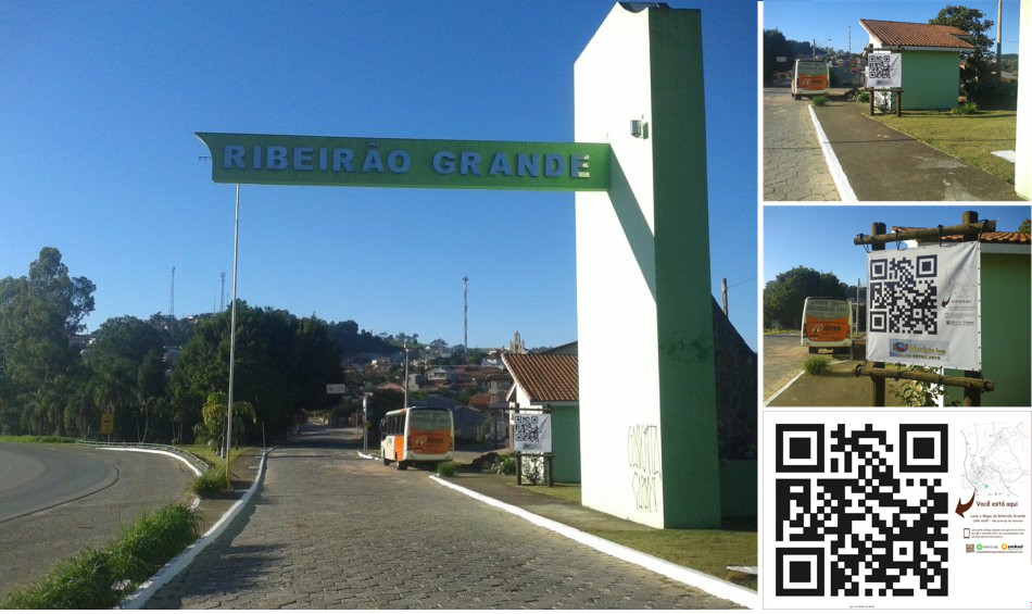
The town hall of Ribeirão Grande, Brazil, put a map, based on OpenStreetMap data, in the town entrance, and a big QR code (representing the string geo:-24.09498,-48.36436?z=19) representing its location (visible here on the openstreetmap.org website). This photo is pointing to the south.
The QR code links to the coordinates of the town: it requires that browsers or QR code readers have a registered handler for the geo: URI scheme (associated with a map application to render it). The URI scheme is formally described in the proposed standard RFC 5870, A Uniform Resource Identifier for Geographic Locations ('geo URI'), published by the Internet Engineering Task Force (IETF) on 2010-06-08.
Photos made by Edil Queiroz.

Front-page image for week 48 of 2017 (27 Nov. – 3 Dec.).
- Image descriptions
- English : The town hall of Ribeirão Grande, Brazil, put in the town entrance a map based on OpenStreetMap data, and a big QR code (containing the string
geo:-24.09498,-48.36436?z=19, an URI for representing its geographic location, based on the standard scheme proposed in RFC 5870). - français : La mairie de Ribeirão Grande (au Brésil) a installé à l’entrée de la ville une carte basée sur les données OpenStreetMap, avec un grand QR code (qui contient la chaîne
geo:-24.09498,-48.36436?z=19, une URI pour représenter son emplacement géographique, basée sur le schéma standard proposé dans la RFC 5870). - italiano : Il Comune di Ribeirão Grande, in Brasile, ha messo una mappa basata su dati OpenStreetMap all'entrata del municipio e un grande QR code (che contiene la stringa
geo:-24.09498,-48.36436?z=19, un URI per rappresentare la sua posizione geografica, sulla base dello schema standard proposto nella RFC 5870). - 中文(简体) : 巴西大里贝朗的市镇厅入口处,有个用开放街图资料为基础的地图,以及大大的QR code (含有字串
geo:-24.09498,-48.36436?z=19,基于editor.org/info/rfc5870 RFC 5870提出的标准格式网址表示这里的地理位置) - 中文(繁體) : 巴西大里貝朗的市鎮廳入口處,有個用開放街圖資料為基礎的地圖,以及大大的 QR code (含有字串
geo:-24.09498,-48.36436?z=19,基於RFC 5870提出的標準格式網址表示這裡的地理位置)
Licensing
![]()
![]()
![]()
Attribution not specified as a parameter! THIS LICENSE ALWAYS REQUIRES ATTRIBUTION! Use {{CC-BY-SA-3.0|Attribution, typically name of author}} See Template:CC-BY-SA-3.0 for full description how this template should be used.
File history
Click on a date/time to view the file as it appeared at that time.
| Date/Time | Thumbnail | Dimensions | User | Comment | |
|---|---|---|---|---|---|
| current | 15:53, 24 November 2017 | | 950 × 565 (138 KB) | Wille (talk | contribs) | The town hall of Ribeirão Grande, Brazil, put a map and a big QR code in the town entrance. The map is made based on OpenStreetMap data and the QR code links to the coordinates of the town. |
You cannot overwrite this file.
File usage
The following 13 pages use this file:
- Featured images/Oct-Dec 2017
- List of featured images/2017
- Pt:Featured images/Oct-Dec 2017
- Uk:Featured images/Oct-Dec 2017
- Zh-hans:Featured images/Oct-Dec 2017
- Zh-hant:Featured images/Oct-Dec 2017
- Template:Iotw image/2017-48
- DE:Featured images/Oct-Dec 2017
- FR:Featured images/Oct-Dec 2017
- ES:Imágenes destacadas/Oct-Dic 2017
- IT:Featured images/Oct-Dec 2017
- RU:Featured images/Oct-Dec 2017
- JA:Featured images/Oct-Dec 2017