File:Ruian-geometry-02.png
Jump to navigation
Jump to search

No higher resolution available.
Ruian-geometry-02.png (183 × 168 pixels, file size: 26 KB, MIME type: image/png)
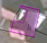
RUIAN budova s chybnou geometrií, 60cm široký "ocásek" podél hranice parcely.
File history
Click on a date/time to view the file as it appeared at that time.
| Date/Time | Thumbnail | Dimensions | User | Comment | |
|---|---|---|---|---|---|
| current | 10:35, 21 June 2014 | | 183 × 168 (26 KB) | Maatts (talk | contribs) | RUIAN budova s chybnou geometrií, 60cm široký "ocásek" podél hranice parcely. |
You cannot overwrite this file.
File usage
The following page uses this file: