File:SRTS walkability after new sidewalk.jpg
Jump to navigation
Jump to search


Size of this preview: 706 × 600 pixels. Other resolutions: 283 × 240 pixels | 565 × 480 pixels | 759 × 645 pixels.
Original file (759 × 645 pixels, file size: 136 KB, MIME type: image/jpeg)
Summary
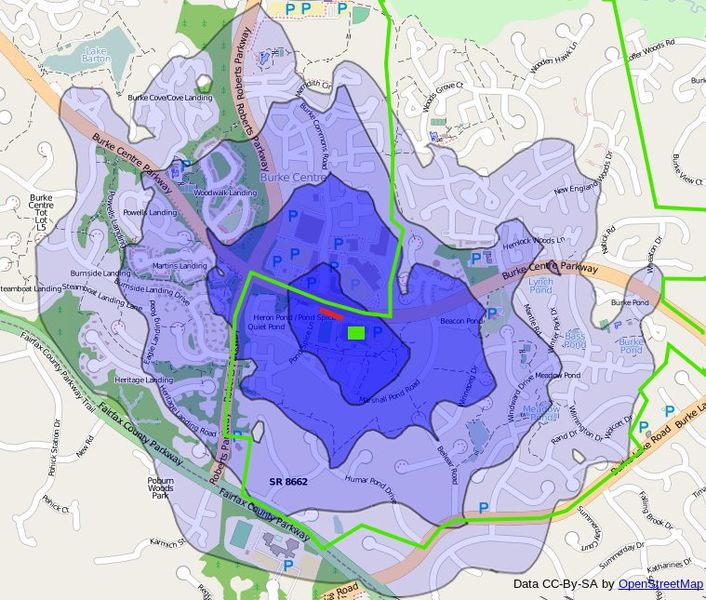
1 mile walkability map for Terra Centre Elementary School after construction of new sidewalk. Created with OSM data, osm2pgrouting, PostgreSQL, PostGIS, PgRouting, QGIS, and GIMP. Each of the black contour lines represent 1/4, 1/2, 3/4, and 1 mile walking distance, only allowing the use of highway=footway/cycleway/path/steps/service/residential. The green line represents the attendance boundary of the school.
Licensing
![]()
![]()
![]()
This work is licensed under the Creative Commons Attribution-ShareAlike 2.0 License.
Attribution not specified as a parameter! THIS LICENSE ALWAYS REQUIRES ATTRIBUTION! Use {{CC-BY-SA-2.0|Attribution, typically name of author}} See Template:CC-BY-SA-2.0 for full description how this template should be used.
Note, there is
There is also
Attribution not specified as a parameter! THIS LICENSE ALWAYS REQUIRES ATTRIBUTION! Use {{CC-BY-SA-2.0|Attribution, typically name of author}} See Template:CC-BY-SA-2.0 for full description how this template should be used.
Note, there is
{{CC-BY-SA-2.0 OpenStreetMap}} for files based on old OSM map data, before the license change made on 2012-09-12.There is also
{{OSM Carto screenshot||old_license}} for files based on old OSM map data, before the license change made on 2012-09-12, created using OSM Carto map style.
File history
Click on a date/time to view the file as it appeared at that time.
| Date/Time | Thumbnail | Dimensions | User | Comment | |
|---|---|---|---|---|---|
| current | 11:56, 18 August 2011 | | 759 × 645 (136 KB) | Joshdoe (talk | contribs) | Add new sidewalk in red |
| 11:53, 18 August 2011 |  | 759 × 645 (136 KB) | Joshdoe (talk | contribs) | 1 mile walkability map for Terra Centre Elementary School after construction of new sidewalk. Created with OSM data, osm2pgrouting, PostgreSQL, PostGIS, PgRouting, QGIS, and GIMP. Each of the black contour lines represent 1/4, 1/2, 3/4 |
You cannot overwrite this file.
File usage
The following 2 pages use this file: