File:SoTM 2014 Montage.jpg
Jump to navigation
Jump to search

Size of this preview: 794 × 599 pixels. Other resolutions: 318 × 240 pixels | 636 × 480 pixels | 1,018 × 768 pixels | 1,224 × 924 pixels.
Original file (1,224 × 924 pixels, file size: 149 KB, MIME type: image/jpeg)
Summary
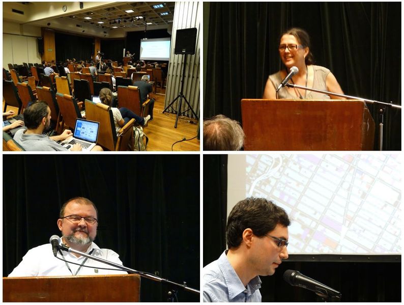
Small selection of Harry's photos from State Of The Map 2014. More on flickr
- Top left: Audience and Joost Schouppe
- Top right: Susanna Ånäs
- Bottom left: Marek Strassenburg Kleciak
- Bottom right: Brett Camper, Mapzen
This is a Featured image, which means that it has been identified as one of the best examples of OpenStreetMap mapping, or that it provides a useful illustration of the OpenStreetMap project. If you know another image of similar quality, you can nominate it on Featured image proposals.
Front-page image for week 46 of 2014 (10–16 Nov.).
- Image descriptions
- Deutsch : Dieses Wochenende hat in Buenos Aires die internationale Konferenz State of the Map 2014 stattgefunden.
- English : The international conference, State Of The Map 2014, took place in Buenos Aires this weekend
- français : La conférence internationale, State Of The Map 2014 (état de la carte 2014), a eu lieu à Buenos Aires ce week-end.
- italiano : La conferenza internazionale State Of The Map 2014, si è tenuta a Buenos Aires lo scorso fine settimana.
- русский : Эти фотографии сделаны на конференции State Of The Map 2014, которая прошла в Буэнос‑Айресе с 7 по 9 ноября.
- 中文(繁體) : 國際會議State Of The Map 2014,這週末在布宜諾艾莉斯舉行。
Licensing
![]()
![]()
![]()
This work is licensed under the Creative Commons Attribution-ShareAlike 2.0 License.
Attribution not specified as a parameter! THIS LICENSE ALWAYS REQUIRES ATTRIBUTION! Use {{CC-BY-SA-2.0|Attribution, typically name of author}} See Template:CC-BY-SA-2.0 for full description how this template should be used.
Note, there is
There is also
Attribution not specified as a parameter! THIS LICENSE ALWAYS REQUIRES ATTRIBUTION! Use {{CC-BY-SA-2.0|Attribution, typically name of author}} See Template:CC-BY-SA-2.0 for full description how this template should be used.
Note, there is
{{CC-BY-SA-2.0 OpenStreetMap}} for files based on old OSM map data, before the license change made on 2012-09-12.There is also
{{OSM Carto screenshot||old_license}} for files based on old OSM map data, before the license change made on 2012-09-12, created using OSM Carto map style.
File history
Click on a date/time to view the file as it appeared at that time.
| Date/Time | Thumbnail | Dimensions | User | Comment | |
|---|---|---|---|---|---|
| current | 14:53, 10 November 2014 | | 1,224 × 924 (149 KB) | Harry Wood (talk | contribs) | State Of The Map 2014 All photos by me |
You cannot overwrite this file.
File usage
The following 7 pages use this file: