File:Spectrum of urban development patterns - Vahid Moosavi.png
Jump to navigation
Jump to search

Size of this preview: 800 × 410 pixels. Other resolutions: 320 × 164 pixels | 640 × 328 pixels | 1,200 × 615 pixels.
Original file (1,200 × 615 pixels, file size: 494 KB, MIME type: image/png)
Summary
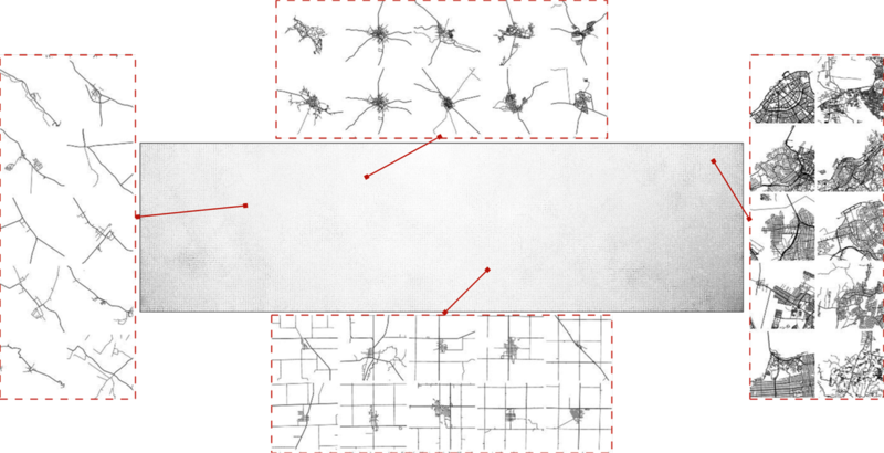
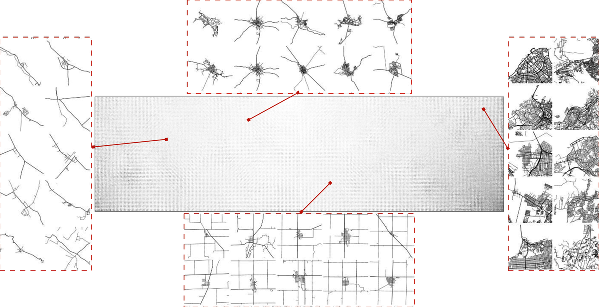
An automatically generated spectrum of urban development patterns for around 1 million cities, towns and villages across the planet
Figure 6. from Vahid Moosavi's paper "Urban morphology meets deep learning: Exploring urban forms in one million cities, town and villages across the planet"
https://arxiv.org/abs/1709.02939 (PDF)
This is a Featured image, which means that it has been identified as one of the best examples of OpenStreetMap mapping, or that it provides a useful illustration of the OpenStreetMap project. If you know another image of similar quality, you can nominate it on Featured image proposals.
Front-page image for week 40 of 2017 (2–8 Oct.).
- Image descriptions
- English : An automatically generated spectrum of urban development patterns for around 1 million cities, towns and villages across the planet. Image from Vahid Moosavi's paper “Urban morphology meets deep learning” (PDF).
- français : Spectre généré automatiquement des motifs de développement urbain pour environ un million de villes ou villages sur toute la planète. Image issue de l’article de Vahid Moosavi « La morphologie urbaine rencontre l’apprentissage en profondeur » (PDF).
- italiano : Spettro generato automaticamente dei pattern di sviluppo per circa 1 milione di città, paesi e villaggi in tutto il pianeta. Immagine tratta dall'articolo di Vahid Moosavi «La morfologia urbana incontra profonde conoscenze» (PDF).
- 中文(简体) : 一个自动产生,大约一百万人尺度的全球城市、城镇和村庄发展图谱。图片来源是 Vahid Moosav 的论文 “Urban morphology meets deep learning” (PDF)。
- 中文(繁體) : 一個自動產生,大約一百萬人尺度的全球城市、城鎮和村莊發展圖譜。圖片來源是 Vahid Moosav 的論文 “Urban morphology meets deep learning” (PDF)。
Licensing
![]()
![]()
![]()
This work is licensed under the Creative Commons Attribution-ShareAlike 2.0 License.
Attribution not specified as a parameter! THIS LICENSE ALWAYS REQUIRES ATTRIBUTION! Use {{CC-BY-SA-2.0|Attribution, typically name of author}} See Template:CC-BY-SA-2.0 for full description how this template should be used.
Note, there is
There is also
Attribution not specified as a parameter! THIS LICENSE ALWAYS REQUIRES ATTRIBUTION! Use {{CC-BY-SA-2.0|Attribution, typically name of author}} See Template:CC-BY-SA-2.0 for full description how this template should be used.
Note, there is
{{CC-BY-SA-2.0 OpenStreetMap}} for files based on old OSM map data, before the license change made on 2012-09-12.There is also
{{OSM Carto screenshot||old_license}} for files based on old OSM map data, before the license change made on 2012-09-12, created using OSM Carto map style.
File history
Click on a date/time to view the file as it appeared at that time.
| Date/Time | Thumbnail | Dimensions | User | Comment | |
|---|---|---|---|---|---|
| current | 23:06, 17 September 2017 | | 1,200 × 615 (494 KB) | Harry Wood (talk | contribs) | An automatically generated spectrum of urban development patterns for around 1 million cities, towns and villages across the planet Figure 6. from Vahid Moosavi's paper "Urban morphology meets deep learning: Exploring urban forms in one million cities... |
You cannot overwrite this file.
File usage
The following 13 pages use this file:
- Featured images/Oct-Dec 2017
- List of featured images/2017
- Pt:Featured images/Oct-Dec 2017
- Uk:Featured images/Oct-Dec 2017
- Zh-hans:Featured images/Oct-Dec 2017
- Zh-hant:Featured images/Oct-Dec 2017
- Template:Iotw image/2017-40
- DE:Featured images/Oct-Dec 2017
- FR:Featured images/Oct-Dec 2017
- ES:Imágenes destacadas/Oct-Dic 2017
- IT:Featured images/Oct-Dec 2017
- RU:Featured images/Oct-Dec 2017
- JA:Featured images/Oct-Dec 2017