File:Stockwell-sketchy-lines.png

Original file (984 × 774 pixels, file size: 237 KB, MIME type: image/png)
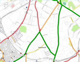
Stockwell (map) done in the sketchy lines style in preparation for London/Summer 2008 Mapping Party Marathon/2008-04-30
Similar to Image:Blackheath-sketchy-lines.png this was rendered by Kosmos to show sketchy greys lines where streets have no name set but have been tagged highway=residential or highway=unclassified.
It should be noted that this rendering fixes bad tagging, rather than encouraging good tagging. The highways without names in areas like this, are clearly sketched over Yahoo Aerial Imagery. As such they shouldn't really have a highway= tag. They should be untagged ways (and then these should be shown as grey lines on the map in my opinion) See Talk:Yahoo! Aerial Imagery#Sketching - Is just tracing useful?
File history
Click on a date/time to view the file as it appeared at that time.
| Date/Time | Thumbnail | Dimensions | User | Comment | |
|---|---|---|---|---|---|
| current | 00:26, 30 April 2008 | | 984 × 774 (237 KB) | Harry Wood (talk | contribs) | Stockwell map done in the sketchy lines style |
You cannot overwrite this file.
File usage
The following page uses this file: