File:Tandale.jpg
Jump to navigation
Jump to search

Size of this preview: 800 × 503 pixels. Other resolutions: 320 × 201 pixels | 640 × 402 pixels | 864 × 543 pixels.
Original file (864 × 543 pixels, file size: 321 KB, MIME type: image/jpeg)
Summary
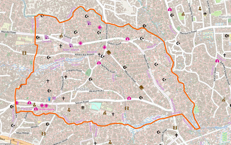
Tandale slum in Dar es Salaam, Tanzania.
http://www.openstreetmap.org/#map=16/-6.7936/39.2467
This is a Featured image, which means that it has been identified as one of the best examples of OpenStreetMap mapping, or that it provides a useful illustration of the OpenStreetMap project. If you know another image of similar quality, you can nominate it on Featured image proposals.
Front-page image for week 8 of 2016 (22–28 Feb.).
- Image descriptions
- asturianu : Tandale en Dar Es Salaam, Tanzania, taba mapeáu con un nivel de detalle densu desde 2009. Recién, el proyeutu Ramani Huria xuntó xente llocal y imáxenes de drones qu'espeyaben los cambios poles enllenes, y qu'aínda amestó más detalles llocales (ver el mapaver el mapa).
- English : Tandale in Dar Es Salaam, Tanzania, has been mapped in dense detail since 2009. Recently the Ramani Huria project involved local people and UAV imagery, updating reflecting flood changes, and adding even more local details (see the mapsee the map).
- italiano : Tandale nel Dar Es Salaam, Tanzania, è stata mappata con molti dettagli fin dal 2009. Recentemente il progetto Ramani Huria ha coinvolto la popolazione locale e immagini da UAV per aggiornarla riflettendo i cambiamenti dovuti alle alluvioni e aggiungere ancora più dettagli locali (guarda la mappaguarda la mappa).
- русский : Район Тандалэ в столице Танзании Дар-эс-Саламе тщательно прорисован в ОСМе ещё с 2009 года. Недавно активисты местного картографического проекта Рамани хуриа обновили эти данные, в том числе при помощи свежих снимков с беспилотников. Уточнены границы подтоплений, появились новые детали (см. карту)(см. карту).
- 中文(简体) : 坦尚尼亚三兰港 Tandale,从 2009 年开始被画得越来越详尽了。最近Ramani Huria 专案有当地民众参与,以及UAV 影像,更新洪水造成的影响,还有加更多在地的细节 (观看地图观看地图)。
- 中文(繁體) : 坦尚尼亞三蘭港 Tandale,從 2009 年開始被畫得越來越詳盡了。最近 Ramani Huria 專案有當地民眾參與,以及 UAV 影像,更新洪水造成的影響,還有加更多在地的細節 (觀看地圖觀看地圖)。
Licensing
| Contains map data © OpenStreetMap contributors, made available under the terms of the Open Database License (ODbL).
The ODbL does not require any particular license for maps produced from ODbL data, produced maps may be subject also to other licences. |
File history
Click on a date/time to view the file as it appeared at that time.
| Date/Time | Thumbnail | Dimensions | User | Comment | |
|---|---|---|---|---|---|
| current | 23:52, 8 February 2016 | | 864 × 543 (321 KB) | Wille (talk | contribs) | Tandale slum in Dar es Salaam, Tanzania |
You cannot overwrite this file.
File usage
The following 9 pages use this file: