File:Terraced-houses.png
Jump to navigation
Jump to search

No higher resolution available.
Terraced-houses.png (307 × 231 pixels, file size: 24 KB, MIME type: image/png)
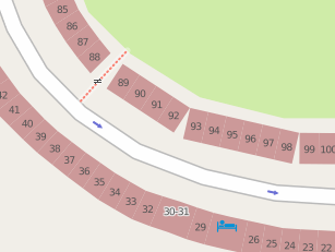
Illustrating Matt's Terraced houses JOSM plugin
Screenshot from Philbeach Gardens, London, UK.
Licensing
![]()
Contains map data © OpenStreetMap contributors, made available under the terms of the Creative Commons Attribution-ShareAlike 2.0 (CC-BY-SA-2.0).
File history
Click on a date/time to view the file as it appeared at that time.
| Date/Time | Thumbnail | Dimensions | User | Comment | |
|---|---|---|---|---|---|
| current | 14:44, 9 March 2009 | | 307 × 231 (24 KB) | Matt (talk | contribs) | Illustrating Matt's Terraced houses JOSM plugin Screenshot from [http://www.openstreetmap.org/?lat=51.490502&lon=-0.199139&zoom=18&layers=B000FTF Philbeach Gardens], London. |
| 12:12, 5 February 2009 |  | 307 × 231 (20 KB) | Harry Wood (talk | contribs) | Illustrating Matt's Terraced houses JOSM plugin |
You cannot overwrite this file.
File usage
The following 3 pages use this file: