File:The-sotm-map.png
Jump to navigation
Jump to search


Size of this preview: 800 × 469 pixels. Other resolutions: 320 × 188 pixels | 640 × 375 pixels.
Original file (1,024 × 600 pixels, file size: 85 KB, MIME type: image/png)
Summary
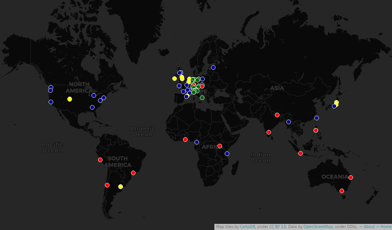
A map of all global, continental and regional State of the Map conferences since 2007:
- international State of the Map conferences, organized by the OpenStreetMap Foundation.
- continental State of the Map conferences (organized by multiple local chapters in a wide region, working in cooperation).
- local State of the Map conferences (organized by local chapters themselves)
- joint conferences hosting local State of the Map sessions (organized by multiple local chapters and partners)
This is a capture of the interactive map, created with UMap.
This is a Featured image, which means that it has been identified as one of the best examples of OpenStreetMap mapping, or that it provides a useful illustration of the OpenStreetMap project. If you know another image of similar quality, you can nominate it on Featured image proposals.
Front-page image for week 28 of 2017 (10–16 Jul.).
- Image descriptions
- Deutsch : Eine historische Karte, die alle State Of The Map-Konferenzen findet, die seit 2007 stattfanden. Eine interaktive Karte ist auch vorhanden, mit UMap gemacht.
- English : An historical map locating all State Of The Map conferences that took place since 2007. An interactive map is also available, made with UMap.
- français : Une carte historique situant toutes les conférences State Of The Map qui ont eu lieu depuis 2007. Une carte interactive est également disponible, réalisée avec UMap.
- italiano : Una mappa storica che mostra tutte le conferenze State Of The Map che si sono svolte dal 2007. È disponibile anche una mappa interattiva creata con UMap.
- 中文(简体) : 一张截至的历史性地图,列出所有全曾举行 State Of The Map 大会地点。另外也有 UMap 版本的 互动地图。
- 中文(繁體) : 一張截至的歷史性地圖,列出所有全曾举行 State Of The Map 大会地点。另外也有 UMap 版本的 互動地圖。
Licensing
The interactive map was built with its own data published under ODbL licence, and published on UMap with background map tiles in CC-BY 3.0 licence (rendered from OpenStreetMap data under ODbL). So the captured image was itself placed in CC-BY-SA 3.0 license to keep both attributions.
![]()
![]()
![]()
This work is licensed under the Creative Commons Attribution-ShareAlike 3.0 License.
Attribution not specified as a parameter! THIS LICENSE ALWAYS REQUIRES ATTRIBUTION! Use {{CC-BY-SA-3.0|Attribution, typically name of author}} See Template:CC-BY-SA-3.0 for full description how this template should be used.
Attribution not specified as a parameter! THIS LICENSE ALWAYS REQUIRES ATTRIBUTION! Use {{CC-BY-SA-3.0|Attribution, typically name of author}} See Template:CC-BY-SA-3.0 for full description how this template should be used.
File history
Click on a date/time to view the file as it appeared at that time.
| Date/Time | Thumbnail | Dimensions | User | Comment | |
|---|---|---|---|---|---|
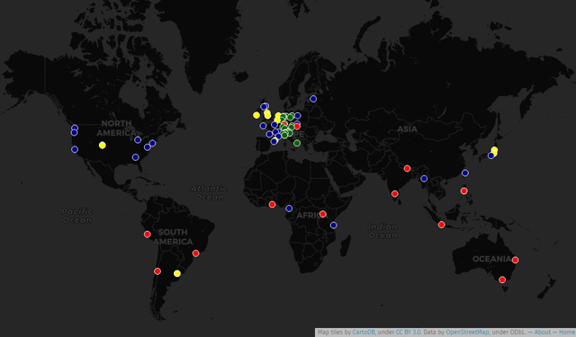
| current | 14:52, 31 July 2018 | | 1,024 × 600 (85 KB) | Verdy p (talk | contribs) | update with new nodes on map |
| 07:38, 1 November 2017 | 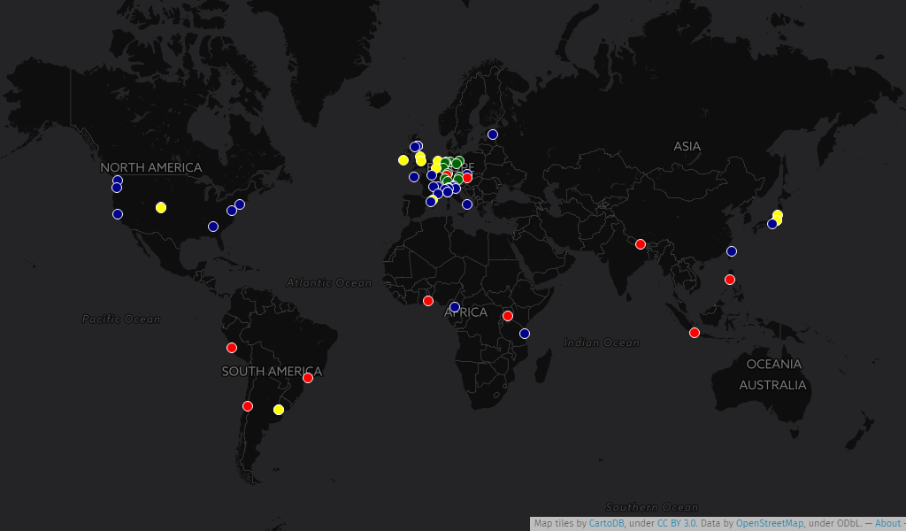 | 1,024 × 600 (94 KB) | Verdy p (talk | contribs) | update for SotM Tanzania 2017 | |
| 12:44, 3 October 2017 | 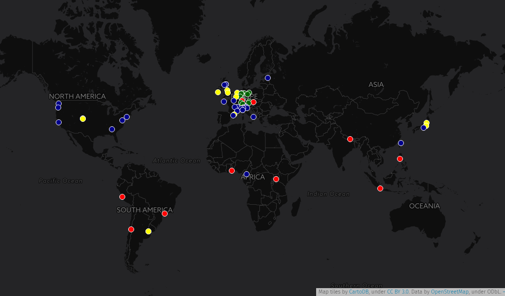 | 1,024 × 600 (93 KB) | Verdy p (talk | contribs) | added events in Africa | |
| 12:35, 18 July 2017 | 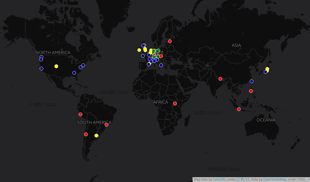 | 1,024 × 600 (91 KB) | Verdy p (talk | contribs) | updated to include past SotM Japan conferences | |
| 20:45, 11 July 2017 | 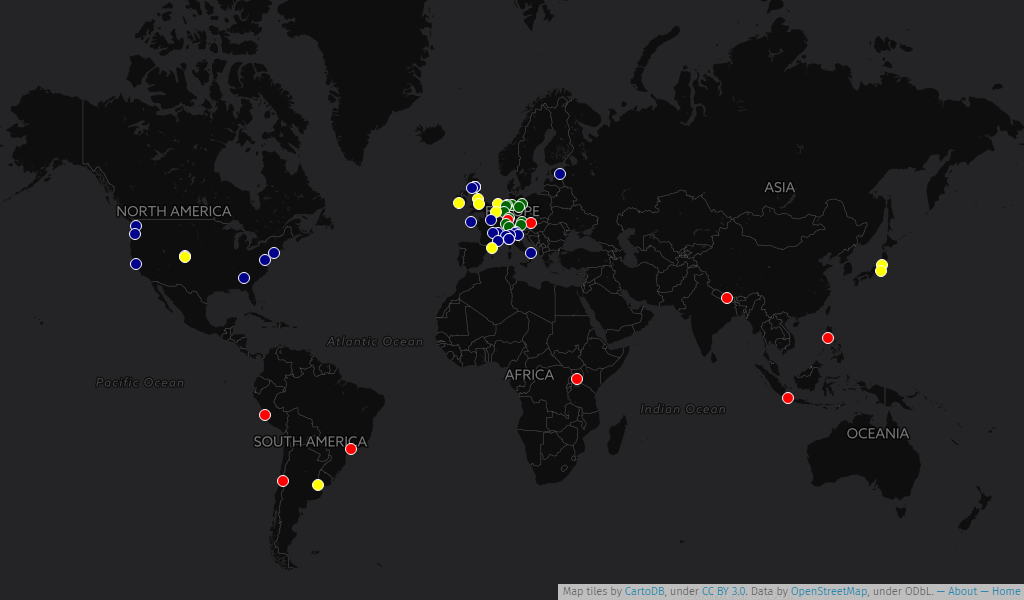 | 1,024 × 600 (94 KB) | Verdy p (talk | contribs) | updated with conferences in Germany/Austria/Switzerland | |
| 14:08, 11 July 2017 | 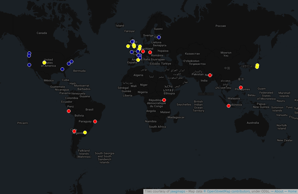 | 975 × 634 (118 KB) | Verdy p (talk | contribs) | updated with all SoTM conferences. Same interactive UMap source | |
| 15:17, 9 July 2017 | 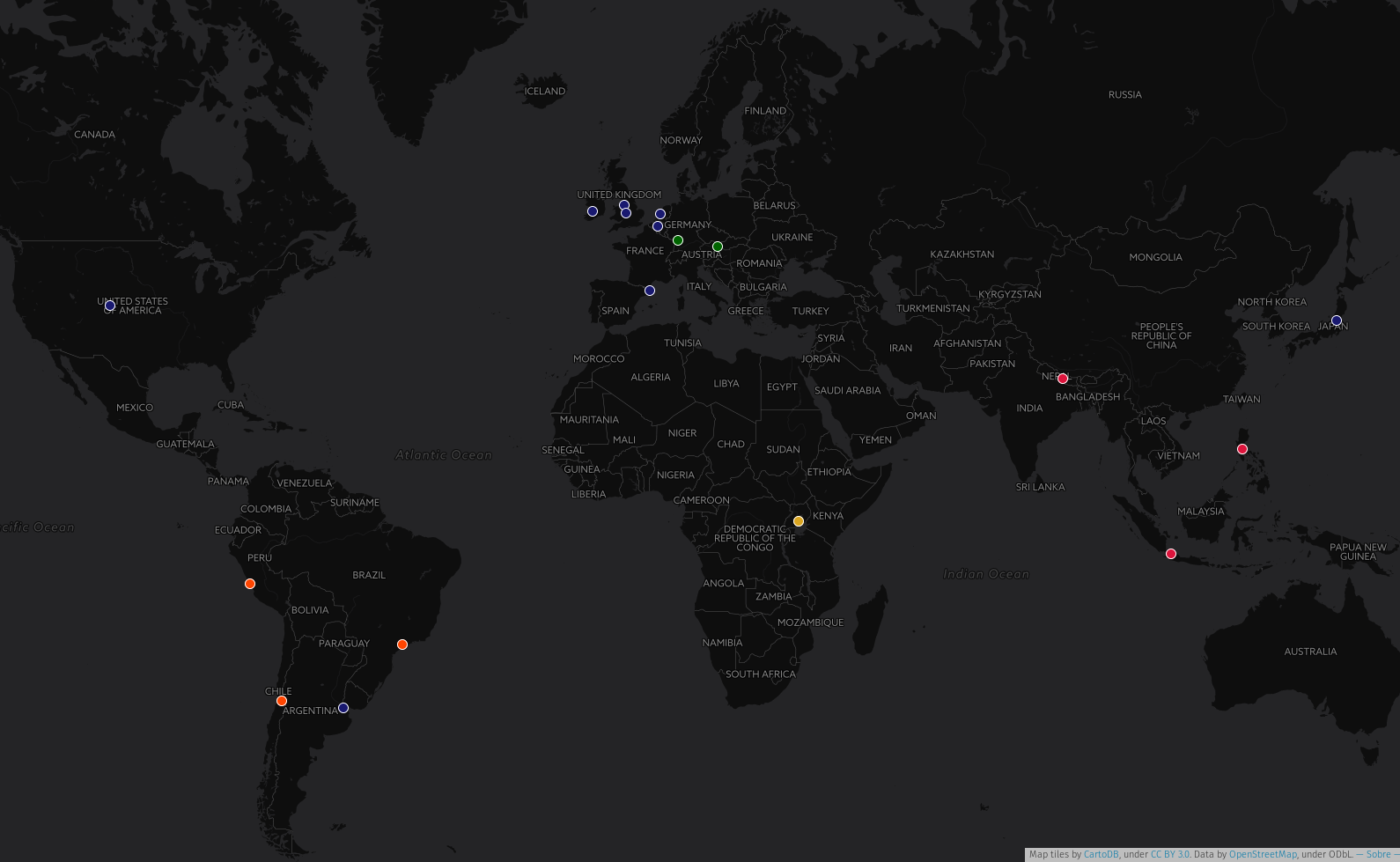 | 1,590 × 979 (341 KB) | Wille (talk | contribs) | A map of all global and continental State of the Map Conferences |
You cannot overwrite this file.
File usage
The following 14 pages use this file:
- Featured images/Jul-Sep 2017
- List of featured images/2017
- Pt:Featured images/Jul-Sep 2017
- State of the Map
- Uk:Featured images/Jul-Sep 2017
- Zh-hans:Featured images/Jul-Sep 2017
- Zh-hant:Featured images/Jul-Sep 2017
- Template:Iotw image/2017-28
- DE:Featured images/Jul-Sep 2017
- FR:Featured images/Jul-Sep 2017
- ES:Imágenes destacadas/Jul-Sep 2017
- IT:Featured images/Jul-Sep 2017
- RU:Featured images/Jul-Sep 2017
- JA:Featured images/Jul-Sep 2017