File:Three large poster maps of Tacloban, Guiuan and Ormoc.jpg
Jump to navigation
Jump to search

Size of this preview: 418 × 600 pixels. Other resolutions: 167 × 240 pixels | 334 × 480 pixels | 640 × 918 pixels.
Original file (640 × 918 pixels, file size: 198 KB, MIME type: image/jpeg)
Summary
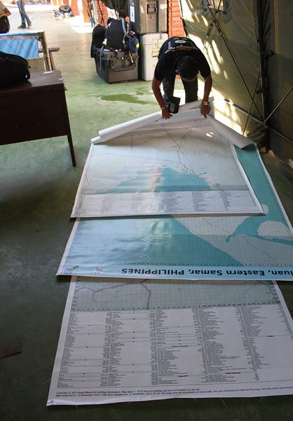
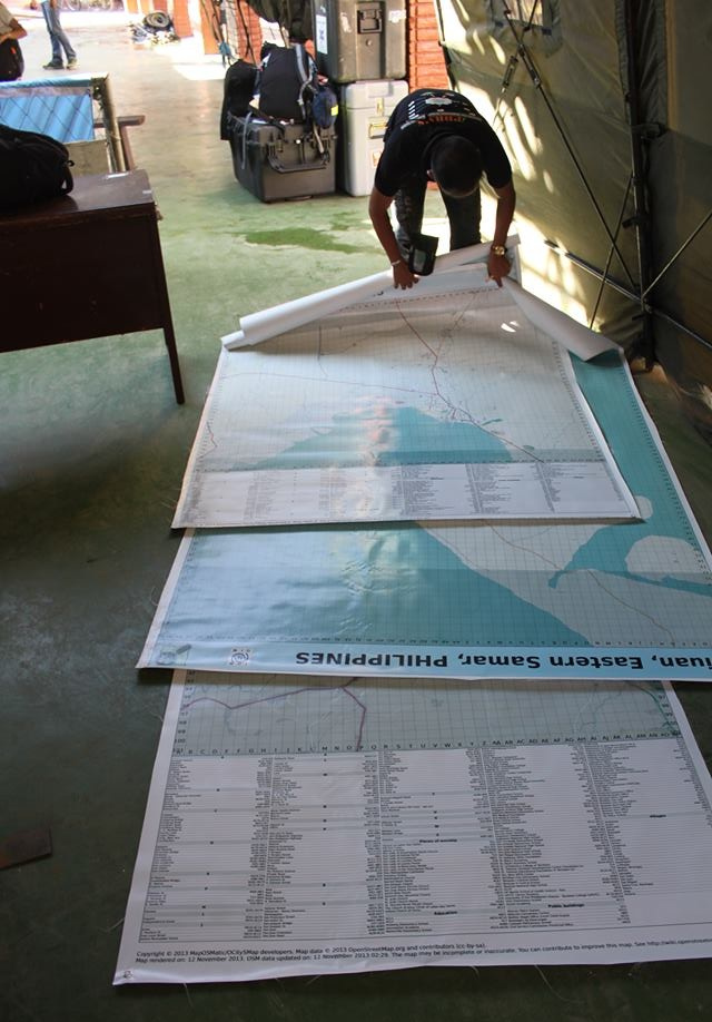
Large poster maps of Tacloban, Guiuan and Ormoc printed and delivered by International Organization on Migration (IOM) in DSWD Operations Center in Tacloban Airport. The map will be used to coordinate the relief and rescue efforts for the victims/survivors of Typhoon Yolanda/Haiyan. Data is from OpenStreetMap printed using MapOSMatic contributed by thousands of OSM volunteers for HOT's Typhoon Ylanda/Haiyan remote mapping activation.
related photo: File:Map Poster DSWD Operations Center.jpg
This is a Featured image, which means that it has been identified as one of the best examples of OpenStreetMap mapping, or that it provides a useful illustration of the OpenStreetMap project. If you know another image of similar quality, you can nominate it on Featured image proposals.
Front-page image for week 48 of 2013 (25 Nov. – 1 Dec.).
- Image descriptions
- Deutsch : Große OSM-basierte Karten von Tacloban, Guiuan und Ormoc wurden von der International Organization on Migration gedruckt und in das DSWD Operations Center im Flughafen von Tacloban geliefert. Die Karten werden bei der Koordination der Hilfs- und Rettungsaktionen der Opfer/Überlebenden des Taifuns Haiyan verwendet werden.
- English : Large OSM-based poster maps of Tacloban, Guiuan and Ormoc printed and delivered by International Organization on Migration in DSWD Operations Center in Tacloban Airport. The maps will be used to coordinate the relief and rescue efforts for the victims/survivors of Typhoon Haiyan.
- español : Un gran póster basado en OSM de Tacloban, Guiuan y Ormoc, impresos por la Organización Internacional de Migración en DSWD y entregado al Centro de Operaciones en el aeropuerto de Tacloban. El mapa será usado para coordinar el rescate y socorro de las victimas/sobrevivientes del Tifón Haiyan.
- français : Cartes OSM format Poster de Tacloban, Guiuan et Ormoc imprimées et livrées par l'Organisation internationale pour les migrations (IOM) au Centre des opérations DSWD à l'aéroport de Tacloban. Les cartes seront utilisées pour coordonner les secours et le sauvetage pour les victimes / survivants du typhon Haiyan.
- italiano : Mappe di Tacloban, Guiuan e Ormoc grandi come cartelloni, basate su OSM, stampate e consegnate dalla International Organization on Migration nel DSWD Operations Center presso l'aeroporto di Tacloban. Le mappe saranno usate per coordinare le operazioni di soccorso per le vittime e i sopravvissuti del tifone Haiyan.
- Nederlands : Grote op OSM gebaseerde kaarten van Tacloban, Guiuan en Ormoc. Deze zijn gedrukt en afgeleverd door de International Organization on Migration in het DSWD-hoofdkwartier op het vliegveld van Tacloban. De kaarten zullen worden gebruikt om de reddingsoperaties voor slachtoffers en overlevenden van de tyfoon Haiyan te coördineren.
- русский : Крупная бумажная карта Таклобана, Гиуана и Ормока, созданная на основе данных ОСМ и сфотографированная в аэропорту Такоблана. Распечатку сделали представители Международной организации по Миграции в Министерстве социального обеспечения и развития Филиппин, чтобы помочь скоординировать спасение людей и поиск жертв после тайфуна Хайан.
- 中文(简体) : 基於開放街圖資料,獨魯萬、Guiuan、Ormoc地區海報大小的地圖,由國際移民組織在獨魯萬機場的DSWD运营中心印制和发送。这些地图会用在协调发送急难救助资源,拯救[Typhoon Haiyan
- 中文(繁體) : 基於開放街圖資料,獨魯萬、Guiuan、Ormoc地區海報大小的地圖,由國際移民組織在獨魯萬機場的DSWD Operations Center印製和發送。這些地圖會用在協調發送急難救助資源,拯救海燕颱風的受難者/存活者。
Licensing
- Photo by Joe Lowry, Senior Communications Officer and Spokesperson at IOM.
- Map data © OpenStreetMap contributors
- source: http://www.flickr.com/photos/esambale/10974569715 , uploaded there by esambale. Info on the license source.
![]()
![]()
![]()
This work is licensed under the Creative Commons Attribution-ShareAlike 2.0 License.
Attribution not specified as a parameter! THIS LICENSE ALWAYS REQUIRES ATTRIBUTION! Use {{CC-BY-SA-2.0|Attribution, typically name of author}} See Template:CC-BY-SA-2.0 for full description how this template should be used.
Note, there is
There is also
Attribution not specified as a parameter! THIS LICENSE ALWAYS REQUIRES ATTRIBUTION! Use {{CC-BY-SA-2.0|Attribution, typically name of author}} See Template:CC-BY-SA-2.0 for full description how this template should be used.
Note, there is
{{CC-BY-SA-2.0 OpenStreetMap}} for files based on old OSM map data, before the license change made on 2012-09-12.There is also
{{OSM Carto screenshot||old_license}} for files based on old OSM map data, before the license change made on 2012-09-12, created using OSM Carto map style.
File history
Click on a date/time to view the file as it appeared at that time.
| Date/Time | Thumbnail | Dimensions | User | Comment | |
|---|---|---|---|---|---|
| current | 16:45, 25 November 2013 | | 640 × 918 (198 KB) | Aseerel4c26 (talk | contribs) | cropped the bottom a bit |
| 16:07, 25 November 2013 | 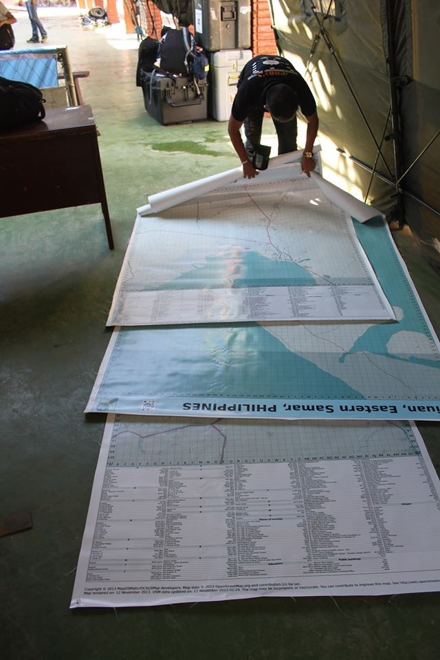 | 640 × 960 (165 KB) | Aseerel4c26 (talk | contribs) | Large poster maps of Tacloban, Guiuan and Ormoc printed and delivered by International Organization on Migration (IOM) in DSWD Operations Center in Tacloban Airport. The map will be used to coordinate the relief and rescue efforts for the victims/survi... |
You cannot overwrite this file.