File:Traffic signals alternative mapping.png
Jump to navigation
Jump to search

Size of this preview: 533 × 600 pixels. Other resolutions: 213 × 240 pixels | 632 × 711 pixels.
Original file (632 × 711 pixels, file size: 464 KB, MIME type: image/png)
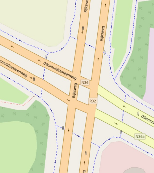
Summary
An alternative methode to map the traffic signals.
Location on OSM: [1]
Licensing
![]()
![]()
This screenshot contains OpenStreetMap Carto rendering.
The OpenStreetMap Carto map style is made available under the Creative Commons CC-0 1.0 Universal Public Domain Dedication.
- Attribution to the map data:
| Contains map data © OpenStreetMap contributors, made available under the terms of the Open Database License (ODbL).
The ODbL does not require any particular license for maps produced from ODbL data, produced maps may be subject also to other licences. |
File history
Click on a date/time to view the file as it appeared at that time.
| Date/Time | Thumbnail | Dimensions | User | Comment | |
|---|---|---|---|---|---|
| current | 13:22, 30 November 2021 | | 632 × 711 (464 KB) | 快乐的老鼠宝宝 (talk | contribs) | Use screenshot in latest OSM-Carto stylesheet |
| 14:45, 18 October 2012 |  | 379 × 378 (51 KB) | Sanderd17 (talk | contribs) | An alternative methode to map the traffic signals. (c) OSM data, rendered with (c) mapnik style. |
You cannot overwrite this file.
File usage
The following 14 pages use this file:
- Cs:Tag:highway=traffic signals
- Hu:Tag:highway=traffic signals
- Ko:Tag:highway=traffic signals
- Pl:Tag:highway=traffic signals
- Pt:Tag:highway=traffic signals
- Tag:highway=traffic signals
- Uk:Tag:highway=traffic signals
- Zh-hans:Tag:highway=traffic signals
- Zh-hant:Tag:highway=traffic signals
- DE:Tag:highway=traffic signals
- FR:Tag:highway=traffic signals
- ES:Tag:highway=traffic signals
- RU:Tag:highway=traffic signals
- JA:Tag:highway=traffic signals