File:TyDresden20050921i0636.jpg
Jump to navigation
Jump to search


Size of this preview: 799 × 211 pixels. Other resolutions: 320 × 85 pixels | 640 × 169 pixels | 2,036 × 538 pixels.
Original file (2,036 × 538 pixels, file size: 520 KB, MIME type: image/jpeg)
This file and its description are from Wikimedia Commons.
Summary
| Description |
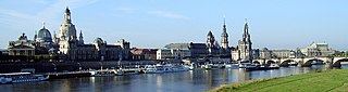
Deutsch: Dresden (Sachsen, Deutschland), Blick von der Carolabrücke (Elbbrücke) in Richtung Südwesten. Am rechten Bildrand die Augustusbrücke, dahinter die Semperoper. Höchstes Bauwerk in der linken Bildhälfte: Kuppel der Frauenkirche. Aufnahmedatum 2005-09-21, geschnittene Digitalaufnahme.
English: Dresden (Saxony, Germany), view from Carola Bridge (over the Elbe river) in southwest direction. On the extreme right: Augustus Bridge and Semperoper (opera house). Highest building in the left half: dome of the Frauenkirche. Image taken 2005-09-21, cropped digital photography. |
| Date | |
| Source | Self-photographed |
| Author | DrTorstenHenning |
| Camera location | | View this and other nearby images on: OpenStreetMap |
|---|
Licensing
| This work has been released into the public domain by its author, DrTorstenHenning. This applies worldwide. In some countries this may not be legally possible; if so: |
File history
Click on a date/time to view the file as it appeared at that time.
| Date/Time | Thumbnail | Dimensions | User | Comment | |
|---|---|---|---|---|---|
| current | 22:32, 3 June 2007 | 2,036 × 538 (520 KB) | wikimediacommons>Unify~commonswiki | fixed colorspace, removed temporary cranes |
File usage
The following page uses this file: