File:Typhoon Haiyan changesets vis.png
Typhoon_Haiyan_changesets_vis.png (785 × 526 pixels, file size: 243 KB, MIME type: image/png)
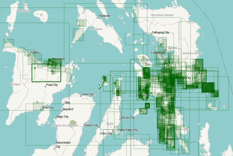
Screenshot of Pascal Neis' resultmap for Typhoon Haiyan
Typhoon Haiyan (Philippines) editing activity visualised. Pascal Neis analysed changesets. In his blog post he reports that we had contributions from 245 different people by Sunday evening, all helping to improve our map data which is being used by aid organisations and crisis responders.
Newer version with a more complete set of changesets:


Front-page image for week 46 of 2013 (11–17 Nov.).
- Image descriptions
- Deutsch : Eine visuelle Darstellung der OSM-Änderungssätze nach Taifun Haiyan. Pascal Neis analysierte die Änderungssätze in den Philippinen und Vietnam. In einem Blog-Artikel berichtet er über seine Arbeit. Am Dienstagabend hatten sich schon über 475 Freiwillige an der Aktion beteiligt, um die Kartendaten, die von Hilfsorganisationen und Krisenhelfern genutzt werden, zu verbessern. Vielen Dank an die OSM-Mitwirkenden und macht weiterhin so gute Arbeit!
- English : Typhoon Haiyan editing activity visualised. Pascal Neis analysed changesets in the Philippines and Vietnam. In his blog post he reports that we had contributions from 245 different people by Sunday evening, all helping to improve our map data which is being used by aid organisations and crisis responders. OSM contributors, thank you and keep up the good work!
- español : Representación visual de las modificaciones después del Tifón Haiyan. Pascal Neis analizó los cambios registrados en Filipinas y Vietnam. Publicando el trabajo en su blog. El martes por la tarde, cerca de 475 voluntarios participaron en la mejora de los datos de los mapas para que sean utilizados por las organizaciones de ayuda y personal de socorro. Contribuidores de OSM, ¡muchas gracias y sigan con el buen trabajo!
- français : Activité sur la cartographie de la zone du Typhoon Haiyan. Pascal Neis a créé une page sur les modifications sur les Philippines et le Vietnam. Sur blog il est signalé qu'il y a déjà 245 personnes différentes qui ont contribué en date du dimanche, Ces améliorations cartographiques sont dès à présent utilisé par les ONG et services de secours sur le terrain. OSM contributeurs, merci et continuez!
- italiano : Visualizzazione delle attività di editing per il Tifone Haiyan. Pascal Neis ha analizzato i changeset nelle Filippine e in Vietnam. Nel suo blog (in inglese) riporta che prima di domenica sera abbiamo avuto contributi da 245 differenti persone, tutte hanno aiutato a migliorare i dati della la nostra mappa che viene usata dalle organizzazioni impegnate negli aiuti e dai soccorritori. Grazie agli utenti OSM che hanno contribuito e continuate a fare un buon lavoro!
- Nederlands : OSM-activiteit vanwege de tyfoon Haiyan in kaart gebracht. Pascal Neis heeft changesets in de Filippijnen en Vietnam geanalyseerd. In zijn blogpost meldt hij dat er al 245 verschillende mensen hebben bijgedragen tot aan zondagavond, om de kaart te verbeteren die nu gebruikt wordt door hulporganisaties. OSM-bijdragers, bedankt en ga zo door!
- русский : Визуализация недавних правок на территории активности тайфуна Хайан. Автор странички Паскаль Нис в своём блоге сообщает, что по состоянию на вечер воскресенья (10 ноября) в проект вовлечены 245 человек. Участники детально прорисовывают местность и обновляют её, а полученную карту активно используют спасательные службы.
- 中文(简体) : 台风海燕受灾区一带的绘图活动视觉化,Pascal Neis分析越南和菲律宾一带的编辑变动。在他的部落格文章中他发现周日晚上就有245个人贡献,协助改善这一带的地图图资,帮助人道组织和救难单位。 开放街图贡献者,感谢你并且继续吧!
- 中文(繁體) : 颱風海燕受災區一帶的繪圖活動視覺化,Pascal Neis分析越南和菲律賓一帶的編輯變動。在他的部落格文章中他發現週日晚上就有245個人貢獻,協助改善這一帶的地圖圖資,幫助人道組織和救難單位。開放街圖貢獻者,感謝你並且繼續吧!
License
![]()
- “copyright © Pascal Neis (neis-one.org)”
- base map tiles: Humanitarian OSM style
- map data © OpenStreetMap contributors
![]()
Files without licences marked with this template are listed in Category:Media without a license or one of its subcategories. If the file is without a known open licence: ask its uploader to clarify situation or find a replacement and mark this file with {{Superseded by Commons}} and replace its uses.
If uploader was notified this month: use {{No licence|subcategory=uploader notified 2024, April}} - to put media into Category:Media without a license - uploader notified 2024, April and mark image as one where uploader was notified.
File history
Click on a date/time to view the file as it appeared at that time.
| Date/Time | Thumbnail | Dimensions | User | Comment | |
|---|---|---|---|---|---|
| current | 13:05, 11 November 2013 | | 785 × 526 (243 KB) | Harry Wood (talk | contribs) | Screenshot of visualisation of changesets for Typhoon Haiyan |
You cannot overwrite this file.
File usage
The following 48 pages use this file:
- 2014 DRC Ebola Response
- 2015 Hurricane Patricia
- 2015 Mariana Dam Collapse
- 2016 Hurricane Matthew
- 2016 Sri Lanka Floods
- 2017 Hurricanes Irma and Maria
- 2017 Mexico Earthquakes
- 2017 South Asian Floods
- 2018 Cyclone Gita - Tonga
- 2018 Papua New Guinea Earthquake
- 2018 South America Flooding
- 2019 Bolivia Wildfires
- 2020 Beirut Port Explosion
- Ayuda Venezuela
- CycloneMolave
- Cyclone Idai
- Cyclone Lekima
- Denizli Earthquakes
- Ecuador-Peru Earthquake
- Featured images/Oct-Dec 2013
- Humanitarian OSM Team/Working groups/Activation/Activation Training
- HurricaneEta
- Hurricane Dorian
- Hurricane Fiona 2022
- Malaria Elimination
- Peru Earthquake
- Philippines/Featured images/2013
- Portuguese Wildfire Mapping
- Pt:2015 Mariana Dam Collapse
- Sunda Strait Tsunami
- Ulawun 2019
- User:Rmayienda/Malaria Elimination
- User:Vgeorge/2017 Chapada dos Veadeiros Fires
- User:Vgeorge/Pt:2017 Chapada dos Veadeiros Fires
- File:Typhoon Haiyan mapping changeset bounding boxes viz by Pascal Neis.png
- Template:Activation
- Template:ES:Activation
- Template:ForAidOrganizations
- Template:Iotw image/2013-46
- Template:Pt:Activation
- DE:Featured images/Oct-Dec 2013
- FR:2014 West Africa Ebola Response
- FR:Featured images/Oct-Dec 2013
- FR:Template:Activation
- ES:2014 West Africa Ebola Response
- ES:2015 Hurricane Patricia
- IT:Featured images/Oct-Dec 2013
- JA:Typhoon Haiyan