File:Warnemünde.png
Jump to navigation
Jump to search

No higher resolution available.
Warnemünde.png (160 × 240 pixels, file size: 5 KB, MIME type: image/png)
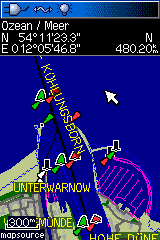
Warnemünde, the harbor of Rostock on a Garmin GPSmap 60Cx, using maps from the OpenSeaMap project.
License: CC-BY-SA 3.0
File history
Click on a date/time to view the file as it appeared at that time.
| Date/Time | Thumbnail | Dimensions | User | Comment | |
|---|---|---|---|---|---|
| current | 22:41, 3 January 2010 | | 160 × 240 (5 KB) | Michi2 (talk | contribs) | Warnemünde, the harbor of Rostock on a Garmin GPSmap 60Cx, using maps from the OpenSeaMap project. License: CC-BY-SA 3.0 Category:Garmin Category:OpenSeaMap |
You cannot overwrite this file.