File:Washington layers.png
Jump to navigation
Jump to search


Size of this preview: 800 × 524 pixels. Other resolutions: 320 × 210 pixels | 640 × 419 pixels | 1,024 × 671 pixels | 1,267 × 830 pixels.
Original file (1,267 × 830 pixels, file size: 637 KB, MIME type: image/png)
Summary
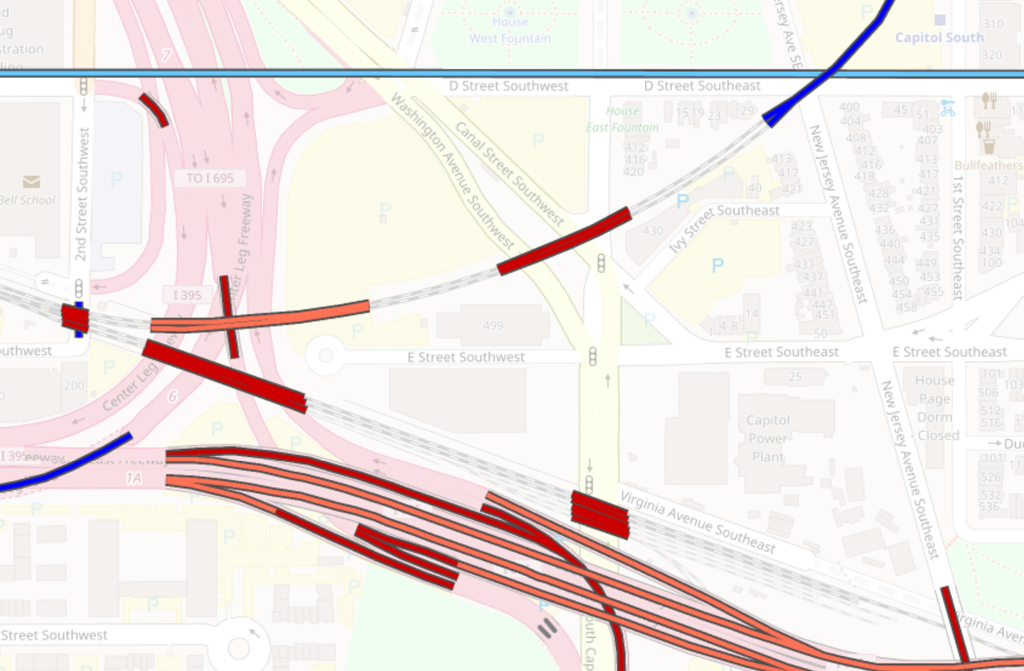
Using the Layers map view from ITO Map to show layer information in Washington. Orange for layer 2, red for layer 1, dark blue for layer -1 and light blue for layer -2.
Licensing
![]()
![]()
![]()
This work is licensed under the Creative Commons Attribution-ShareAlike 2.0 License.
Attribution not specified as a parameter! THIS LICENSE ALWAYS REQUIRES ATTRIBUTION! Use {{CC-BY-SA-2.0|Attribution, typically name of author}} See Template:CC-BY-SA-2.0 for full description how this template should be used.
Note, there is
There is also
Attribution not specified as a parameter! THIS LICENSE ALWAYS REQUIRES ATTRIBUTION! Use {{CC-BY-SA-2.0|Attribution, typically name of author}} See Template:CC-BY-SA-2.0 for full description how this template should be used.
Note, there is
{{CC-BY-SA-2.0 OpenStreetMap}} for files based on old OSM map data, before the license change made on 2012-09-12.There is also
{{OSM Carto screenshot||old_license}} for files based on old OSM map data, before the license change made on 2012-09-12, created using OSM Carto map style.
File history
Click on a date/time to view the file as it appeared at that time.
| Date/Time | Thumbnail | Dimensions | User | Comment | |
|---|---|---|---|---|---|
| current | 14:06, 1 February 2017 | | 1,267 × 830 (637 KB) | Zstadler (talk | contribs) | Color scheme of the site was updated. New screenshot with higher resolution. |
| 06:53, 23 June 2011 |  | 845 × 549 (293 KB) | PeterIto (talk | contribs) | Using the Layers map view from ITO Map to show layer information. Orange for layer 2, red for layer 1, dark blue for layer -1 and light blue for layer -2. |
You cannot overwrite this file.
File usage
The following 73 pages use this file:
- Ar:Properties
- Ast:Map Features
- Az:Map Features
- Az:Properties
- Bg:Map Features
- Cs:Key:layer
- Cs:Map Features2
- Cs:Vlastnosti
- Da:Map Features
- Da:Properties
- El:Map Features
- Eo:Map Features
- Fa:Key:layer
- Fa:Map Features
- Fi:Kartan ominaisuudet
- Fi:Key:layer
- Fi:Ominaisuudet
- He:Map Features
- Hu:Map Features
- Hu:Properties
- Id:Map Features
- Id:Properties
- Key:layer
- Lv:Map Features
- Map features
- Ne:Map Features
- Pl:Key:layer
- Pl:Właściwości
- Properties
- Pt:Properties
- Ro-md:Map Features
- Ro:Map Features
- Sr:Map Features
- Sv:Map Features
- Uk:Key:layer
- Uk:Properties
- Zh-hans:Key:layer
- Zh-hans:Map Features
- Zh-hant:Key:layer
- Zh-hant:Properties
- User:Chillly/Simple Map Features
- Wiki:Files used by data items/5
- Template:Ar:Map Features:properties
- Template:Az:Map Features:properties
- Template:Cs:Map Features:properties
- Template:DE:Map Features:properties
- Template:Da:Map Features:properties
- Template:Et:Map Features:properties
- Template:FR:Map Features:properties
- Template:Fi:Map Features:properties
- Template:Generic:ES:Map Features:properties
- Template:Hu:Map Features:properties
- Template:IT:Map Features:properties
- Template:Id:Map Features:properties
- Template:JA:Map Features:properties
- Template:Map Features:properties
- Template:NL:Map Features:properties
- Template:Pl:Map Features:properties
- Template:Pt:Map Features:properties
- Template:RU:Map Features:properties
- Template:Uk:Map Features:properties
- Template:Zh-hant:Map Features:properties
- DE:Eigenschaften
- FR:Key:layer
- FR:Propriétés
- ES:Key:layer
- ES:Propiedades
- IT:Key:layer
- NL:Properties
- RU:Key:layer
- RU:Properties
- JA:Key:layer
- JA:属性