File:Waterloo.png
Jump to navigation
Jump to search

No higher resolution available.
Waterloo.png (306 × 383 pixels, file size: 107 KB, MIME type: image/png)
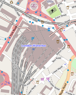
Waterloo railway station connects to other transportation networks with footways, access roads and subway stations. Amenities within the station and nearby are mapped.
Licensing
![]()
![]()
![]()
This screenshot contains OpenStreetMap Carto rendering.
The OpenStreetMap Carto map style is made available under the Creative Commons CC-0 1.0 Universal Public Domain Dedication.
- Attribution to the map data:
![]()
Contains map data © OpenStreetMap contributors, made available under the terms of the Creative Commons Attribution-ShareAlike 2.0 (CC-BY-SA-2.0).
File history
Click on a date/time to view the file as it appeared at that time.
| Date/Time | Thumbnail | Dimensions | User | Comment | |
|---|---|---|---|---|---|
| current | 23:26, 1 December 2010 | | 306 × 383 (107 KB) | Rw (talk | contribs) | Waterloo railway station connects to other transportation networks with footways, access roads and subway stations. Amenities within the station and nearby are mapped. cc-by-sa |
You cannot overwrite this file.
File usage
The following 3 pages use this file: