File:Westwall-ln-nl.jpg
Jump to navigation
Jump to search


Size of this preview: 342 × 599 pixels. Other resolutions: 137 × 240 pixels | 274 × 480 pixels.
Original file (800 × 1,400 pixels, file size: 261 KB, MIME type: image/jpeg)
This file and its description are from Wikimedia Commons.
Summary
| Description |
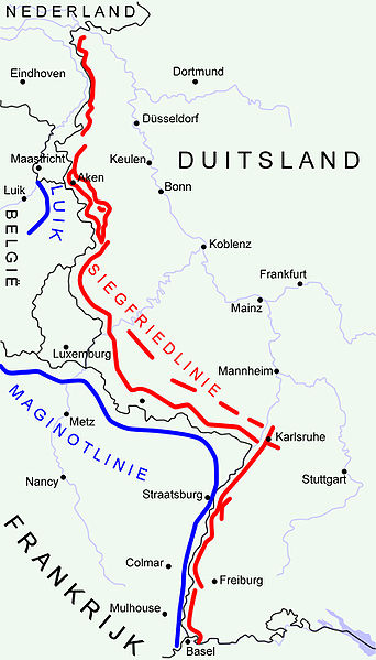
"Siegfried Line" (aka Westwall) (military defensive line) in Germany 1940 in red. "Maginotline" in blue. Disclaimer: The exact location of the lines may differ from reality to a slight extent. Made by Niels Bosboom. Based on map GNU FDL: Image:Karte westwall.png |
| Date | 31 January 2006 (original upload date) |
| Source | No machine-readable source provided. Own work assumed (based on copyright claims). |
| Author | No machine-readable author provided. NielsB assumed (based on copyright claims). |
Licensing
I, the copyright holder of this work, hereby publish it under the following license:
This file is licensed under the Creative Commons Attribution-Share Alike 3.0 Unported license.
- You are free:
- to share – to copy, distribute and transmit the work
- to remix – to adapt the work
- Under the following conditions:
- attribution – You must give appropriate credit, provide a link to the license, and indicate if changes were made. You may do so in any reasonable manner, but not in any way that suggests the licensor endorses you or your use.
- share alike – If you remix, transform, or build upon the material, you must distribute your contributions under the same or compatible license as the original.
File history
Click on a date/time to view the file as it appeared at that time.
| Date/Time | Thumbnail | Dimensions | User | Comment | |
|---|---|---|---|---|---|
| current | 19:31, 31 January 2006 | | 800 × 1,400 (261 KB) | wikimediacommons>NielsB | == Description == "Siegfried Line" (aka Westwall) (military defensive line) in Germany 1940 in red. "Maginotline" in blue. Disclaimer: The exact location of the lines may differ from reality to a slight extent. Made by Niels Bosboom. Based on map GNU FDL: |
File usage
The following page uses this file: