File:Weybridge gardens.png
Jump to navigation
Jump to search


No higher resolution available.
Weybridge_gardens.png (600 × 450 pixels, file size: 306 KB, MIME type: image/png)
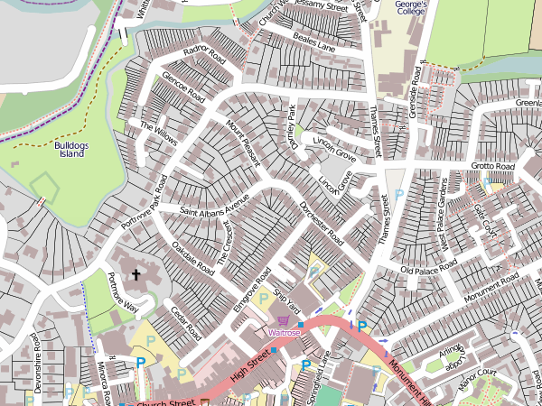
http://www.openstreetmap.org/?lat=51.37088&lon=-0.45852&zoom=16&layers=M (in Weybridge)
This is a Featured image, which means that it has been identified as one of the best examples of OpenStreetMap mapping, or that it provides a useful illustration of the OpenStreetMap project. If you know another image of similar quality, you can nominate it on Featured image proposals.
Front-page image for week 51 of 2011 (19–25 Dec.).
- Image descriptions
- Deutsch : Zäune und Gartenhäuschen in Weybridge
- English : Fences and garden sheds in Weybridge
- italiano : Recinzioni e casette a Weybridge
- русский : Данные под лицензией Creative Commons, которые будут удалены до 1 апреля 2012г.
- 中文(简体) : 威布里奇的栏杆和花园棚子
- 中文(繁體) : 威布里奇的欄杆和花園棚子
File history
Click on a date/time to view the file as it appeared at that time.
| Date/Time | Thumbnail | Dimensions | User | Comment | |
|---|---|---|---|---|---|
| current | 12:04, 17 October 2010 | | 600 × 450 (306 KB) | Ojw (talk | contribs) | http://www.openstreetmap.org/?lat=51.37088&lon=-0.45852&zoom=16&layers=M |
You cannot overwrite this file.
File usage
The following 11 pages use this file:
- Featured images/Oct-Dec 2011
- KT13 Weybridge
- List of featured images/2011
- Template:DE:Featured image p4
- Template:FR:Featured image p4
- Template:Featured image h4
- Template:Featured image p4
- Template:Iotw image/2011-51
- DE:Featured images/Oct-Dec 2011
- FR:Featured images/Oct-Dec 2011
- IT:Featured images/Oct-Dec 2011