File:Yahoo! Aerial Imagery Coverage Melbourne.png
Jump to navigation
Jump to search


Size of this preview: 503 × 600 pixels. Other resolutions: 201 × 240 pixels | 509 × 607 pixels.
Original file (509 × 607 pixels, file size: 257 KB, MIME type: image/png)
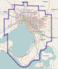
The aerial photography coverage for Melbourne, Australia as provided by Yahoo!. Inside the bordered area there is coverage.
![]()
Contains map data © OpenStreetMap contributors, made available under the terms of the Creative Commons Attribution-ShareAlike 2.0 (CC-BY-SA-2.0).
File history
Click on a date/time to view the file as it appeared at that time.
| Date/Time | Thumbnail | Dimensions | User | Comment | |
|---|---|---|---|---|---|
| current | 00:29, 14 May 2008 | | 509 × 607 (257 KB) | Lakeyboy (talk | contribs) | The aerial photography coverage for Melbourne, Australia as provided by Yahoo!. Inside the bordered area there is coverage. |
You cannot overwrite this file.
File usage
There are no pages that use this file.