File:Zaragoza-August2011.png
Jump to navigation
Jump to search


Size of this preview: 600 × 600 pixels. Other resolutions: 240 × 240 pixels | 480 × 480 pixels | 768 × 768 pixels | 1,024 × 1,024 pixels | 1,300 × 1,300 pixels.
Original file (1,300 × 1,300 pixels, file size: 1.56 MB, MIME type: image/png)
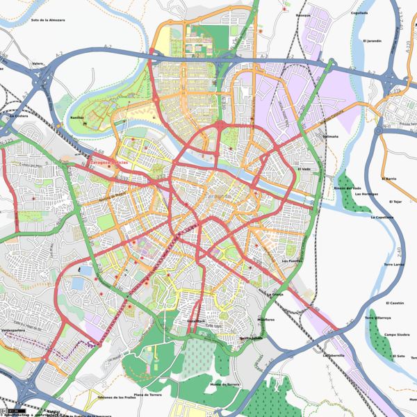
Map of Zaragoza, in Spain, as seen in August 2011. Tram has been added. Actur and Expo Zaragoza areas have been greatly improved. Several new sites added.
Map of Zaragoza
This map and others like it, were created by OpenStreetmap contributors, and are licensed as Creative Commons CC-BY-SA 2.0 (https://creativecommons.org/licenses/by-sa/2.0/) (see OpenStreetMap licence).
Use {{mapof|PlaceName}} to add this template to your images.
This map and others like it, were created by OpenStreetmap contributors, and are licensed as Creative Commons CC-BY-SA 2.0 (https://creativecommons.org/licenses/by-sa/2.0/) (see OpenStreetMap licence).
Use {{mapof|PlaceName}} to add this template to your images.
File history
Click on a date/time to view the file as it appeared at that time.
| Date/Time | Thumbnail | Dimensions | User | Comment | |
|---|---|---|---|---|---|
| current | 11:07, 5 August 2011 | | 1,300 × 1,300 (1.56 MB) | Jynus (talk | contribs) | Map of Zaragoza, in Spain, as seen in August 2011. Tram has been added. Actur and Expo Zaragoza areas have been greatly improved. Several new sites added. {{mapof|Zaragoza}} |
You cannot overwrite this file.
File usage
The following 2 pages use this file: