IT:GpsPrune
Jump to navigation
Jump to search
| GpsPrune | |
|---|---|
| Autore: | activityworkshop.net |
| Licenza: | GNU General Public License |
| Piattaforma: | Windows, Linux e macOS |
| Versione: | 20.2 (2021-01-01) |
| Linguaggio: | afrikaans, ceco, tedesco, alto tedesco svizzero, inglese, spagnolo, francese, ungherese, italiano, giapponese, coreano, olandese, polacco, portoghese brasiliano, rumeno, russo, cinese, (or partially), danese, indonesiano, persiano, turco, ucraino e svedese |
| Sito web: | http://gpsprune.activityworkshop.net/ |
| Linguaggio di programmazione: | Java |
|
Track editor, analyser, creator and converter | |
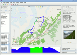
Prune è una applicazione per la gestione di dati GPS. Consente, a partire da dati in file di test, XML o NMEA, di visualizzarli con openstreetmap e profilo di quota, editarli ed esportarli in formati di testo oppure in XML, GPX, KML/KMZ (Google Earth).
It's written in Java and runs on Windows, Linux, Mac and Solaris. The supported languages are English, French, German, Spanish, Italiano, Polish, Chinese, Japanese and Portuguese. Further languages are partially supported, including Turkish, Romanian and Afrikaans.
Link: http://activityworkshop.net/software/prune/
More screenshots: http://activityworkshop.net/software/prune/screenshots.html
Features
- Loading data (text, csv, gpx, kml, kmz, nmea) or from GPS receivers using GPSBabel
- Viewing data with a map view using OSM maps (mapnik by default, other renderers configurable)
- Altitude profile view, 3D view using java3d, details like distances, durations, speeds
- Editing data (delete individual points or sections, automatic variable compression, combine and rearrange data, create and edit individual points)
- Exporting data (text, csv, gpx, kml, kmz) or to povray format for 3D rendering; sending data to GPS receiver
- Geotagging photos (manually or automatically using timestamps)
- Exporting photo thumbnails to kmz format, and saving coordinates in photo files using ExifTool
- Charting (eg altitude against time, speed against distance) either on screen or output to svg file
Current version: 10 (Maggio 2010)
