File:Coventry-ring-road-20080713-osma-z16-scaled.png
Original file (867 × 530 pixels, file size: 534 KB, MIME type: image/png)
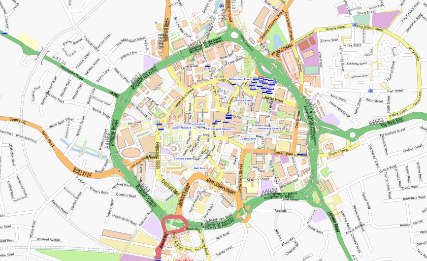
Coventry city centre; as of 2007-07-13 showing extent of ring-road "boundary" and micro-mapping inside. Produced from [1] followed by a zoom-out and fast "print-screen" cropped in The GIMP.
Coventry Ring Road (A4053) is a 2.2 mile (3.5 km) dual carriageway encircling the centre of the city of Coventry, in Central England. Junction 1 (J1) is a roundabout and the remaining J2-J9 are grade-separated complexes, making one complete grade-separated junction every 350 metres (1/4 mile)---and a large amount of weaving... The 4 to 8 lane concrete and elevated structure provides a psychological and physical barrier! Virtually all shopping and night life facilities are constricted to an area of ~1km2; providing a good boundary for micro-mapping.
The centre was mapped nightly in JOSM after spending 4-5 days repeatedly wandering around the centre, noting down names, exploring and memorising the location and relationship of buildings (no overhead imagery is available). Following heavy World War II damage, the city received a fresh-start with The Precinct shopping centre area, separating pedestrians from "this new fangled motorcar traffic", an idea later followed elsewhere. Coventry is known for its association with car-manufacturing and Coventry Transport Museum is contained within this area, along with the Coventry Cathedral(s).
The discovery of an extensive (and interconnected) roof-top car-park system in the SW corner reminded me of the film The Italian Job (indeed, the tunnel chase sequence in the movie was filmed in the new Coventry Sewer system ...before opening). Coventry railway station and Coventry Canal Basin are both just outside the ring and Pool Meadow Bus Station just inside. Mapping had to be curtailed (for the moment) after collecting my first ever parking ticket, for mooring my narrowboat Jubilee more than the 48 hours on the visitor moorings! (Perhaps I should have checked maxstay=48!).

Front-page image on 25 Oct 2008
File history
Click on a date/time to view the file as it appeared at that time.
| Date/Time | Thumbnail | Dimensions | User | Comment | |
|---|---|---|---|---|---|
| current | 00:55, 13 July 2008 | | 867 × 530 (534 KB) | Sladen (talk | contribs) | Coventry city centre; as of 2007-07-13 showing extent of ring-road "boundary" and micro-mapping inside. Produced from [http://www.openstreetmap.org/?lat=52.408&lon=-1.51&zoom=16] followed by a zoom-out and fast "print-screen" cropped in The GIMP. |
You cannot overwrite this file.
File usage
The following 2 pages use this file: