File:Edited TIGER map LA.png
Original file (711 × 630 pixels, file size: 822 KB, MIME type: image/png)
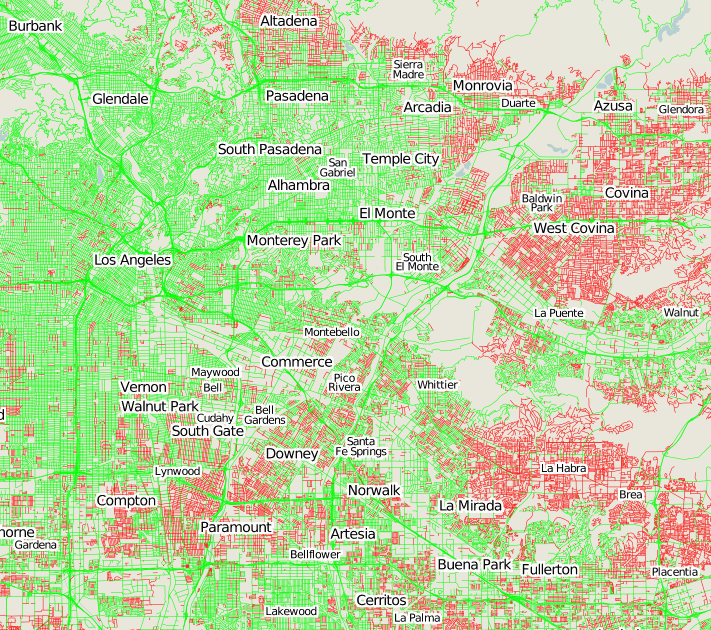
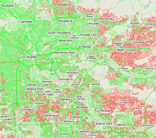
TIGER Edited Map showing areas which areas which have been edited since the TIGER import.
This image shows Los Angeles, California in the old TIGER edited map which Matt made, which is offline now (original URL for los angeles) The area is here on the new TIGER edited map. Curiously the area was looking more green before. Must be a difference in the way the new map is deciding if data was edited. Can anyone explain that?
(green is good). The vast majority of TIGER data requires some TIGER fixup of one form or another, so we would expect this whole map to turn green in areas where people are working on improving the map. Have you turned your area green yet?

Front-page image for week 45 of 2009 (2–8 Nov.).
- Image descriptions
- Deutsch : Die TIGER Edited Map [1] zeigt den Fortschritt bei der Reparatur der TIGER-Daten der USA.
- English : The TIGER Edited Map [2] shows progress with TIGER fixup in the U.S. Have you turned your area green yet?
- italiano : La TIGER Edited Map [3] mostra il progresso del TIGER fixup negli Stati Uniti. Le zone verdi sono quelle già corrette.
- magyar : A TIGER szerkesztett térkép [4] mutatja a TIGER javítási folyamatot az Egyerült Államokon belül. Már átfordítottad a területedet zöldbe?
- polski : Mapka modyfikacji w danych TIGER [5] pokazuje postępy w poprawianiu importu z TIGER. Jeśli jesteś w Stanach, zazieleń swoją okolicę!
- suomi : Voit seurata TIGER Edited Map -kartalta [6] OpenStreetMapiin tuodun TIGER -datan korjausta Yhdysvalloissa. Voit auttaa vaikket olisi käynyt paikalla, oletko jo osallistunut?
- български : Картата TIGER Edited Map [7] показва напредъка с TIGER fixup в САЩ.
- русский : TIGER Edited Map [8] показывает статус выправки TIGER в США.
File history
Click on a date/time to view the file as it appeared at that time.
| Date/Time | Thumbnail | Dimensions | User | Comment | |
|---|---|---|---|---|---|
| current | 12:15, 28 September 2009 | | 711 × 630 (822 KB) | Harry Wood (talk | contribs) | TIGER Edited Map showing areas which areas which have been edited since the [[TIGER] import. Los Angeles, California |
You cannot overwrite this file.