File:Gaza tourist.png
Jump to navigation
Jump to search


Size of this preview: 800 × 597 pixels. Other resolutions: 320 × 239 pixels | 640 × 478 pixels | 1,024 × 764 pixels | 1,162 × 867 pixels.
Original file (1,162 × 867 pixels, file size: 977 KB, MIME type: image/png)
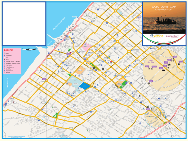
from Mikel: http://www.flickr.com/photos/mikel_maron/3839596813/
This is a Featured image, which means that it has been identified as one of the best examples of OpenStreetMap mapping, or that it provides a useful illustration of the OpenStreetMap project. If you know another image of similar quality, you can nominate it on Featured image proposals.
Front-page image for week 39 of 2009 (21–27 Sep.).
- Image descriptions
- čeština : Turistická mapa Pásma Gaza. Nevídané u komerčních poskytovatelů map.
- Deutsch : Eine touristische Karte des Gaza-Streifens! Würde man sowas jemals auf einer kommerziellen Karte sehen?
- English : A tourist map of the Gaza strip! Would you ever see this from a commercial map?
- español : ¡Un mapa turístico de la franja de Gaza! ¿Habías visto alguna vez algo así en un mapa comercial?
- français : Une carte touristique de la Bande de Gaza !
- italiano : Una mappa turistica della Striscia di Gaza! L'hai mai vista su una mappa commerciale?
- latviešu : Gazas joslas tūristu karte. Vai esat redzējuši ko tādu komerciālā kartē?
- magyar : A Gázai övezet turistatérképe! Látnál ilyet egy kereskedelmi térképen?
- Nederlands : Een toeristenkaart van de Gazastrook! Zou je dit ooit op een commerciële kaart zien?
- polski : Mapa turystyczna Strefy Gazy! Czy zobaczyłbyś to na mapie komercyjnej?
- suomi : Turistikartta Gazan alueesta.
File history
Click on a date/time to view the file as it appeared at that time.
| Date/Time | Thumbnail | Dimensions | User | Comment | |
|---|---|---|---|---|---|
| current | 19:21, 24 August 2009 | | 1,162 × 867 (977 KB) | Ojw (talk | contribs) |
You cannot overwrite this file.