JA:タイル
タイル (Tiles) は、風呂場の壁に格子状に貼り付けてある、四角い陶器の板のことです! しかし、ここではそれよりも地図タイルについて説明します。
- 地図を表示するために格子状に並べて表示されている、四角いビットマップのグラフィック
- タイル状にした地図のデータについて触れることもあります。
このページは多くの情報や技術的な詳細を含んでいます。ウェブページやアプリケーションで地図タイルを利用したい場合は、 how to use OpenStreetMap tiles についてのチュートリアルを見ることもできます。
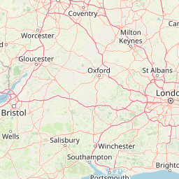
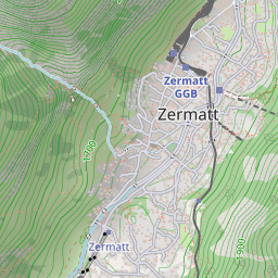
グラフィカルな地図タイル
地図タイルは通常256×256ピクセルの画像です。例えば、以下のようなものです。
タイルは常にこの大きさとは限りません。例えば、モバイル用には64×64ピクセルの画像になることもありますが、256×256ピクセルの画像が事実上の標準です。高解像度タイルでは、標準のサイズは512×512ピクセルのようです。
「タイルセット」(tileset)は通常、一度に表示されると巨大な画像を形成するのに十分なタイルを含んでおり、様々なズームレベルにもなります。一般的に、この考えはウェブサイト上にすべてを同時に表示するものではなく、地図上の特定のエリアを表示するものです。移動やズームの機能、地図の新しい領域をユーザーが表示させる必要があるときに新しいタイルのダウンロードを要求する機能は、 Javascript の地図ライブラリによって実現されます(スリッピーマップ)。
タイルの利用
- JA:閲覧#レイヤーでは、 openstreetmap.org ホームページに表示できるタイルの選択を説明しています
- Mapnik - 有名なタイルのレンダラー
- Kosmos Tile Map Server - Windows のタイルレンダラー
- Tile usage policy
- Exporting calibrated maps 特定の組込みソフトウェアと互換性を持つタイルを得るためのツールの一覧
- Tiletool は地図タイル処理のユーティリティです。低倍率のタイルと高倍率のタイルを組み合わせて作成することができ、それらと他の便利な機能を重ねて表示できます。
技術的なデータ
- Slippy map tilenames - 座標からタイル名を計算
- ディスク使用量の見積。
- Tile water land status ([3],OSM slippy map において、どのタイルが地表か海面かであることのインデックスで、これはSVN中のfile available中のpng2tileinfo中のファイルである。
- List of changed tiles,最近の1時間から24時間中で変更のあった、すべてのタイルをすべてのズームレベルで得る。
開発
- mod_tile Mapnik のタイルをレンダリングするためにプロセスを分岐させる Apache モジュールです。 OSM-Dev メーリングリストの "mod_tile / renderd issue" (2008年5月)を参照してください
- Tile cache, mapnik/mapserver/WMS で地図を描画し、それをタイルとしてキャッシュ。
- OSM Mobile Binary Protocol、タイリングした OSM データ(WhereAmI/OSM Binary Format およびメーリングリストの2008年からの "mobile binary data" スレッドの議論も参照してください)
サーバー
See Servers/tile for the names of the physical servers that serve openstreetmap.org's map tiles.
See Servers/Tile CDN for description of tile servers maintained by OSM and how one may donate new server to it.{x} and {y} should be replaced with the x and y tile numbers.
{z} should be replaced with the zoom level.
{s} should be replaced by a subdomain. The exact values are in the tile server's documentation, but typically it is a single letter a, b, c and usually corresponds to Leaflet's {s} parameter[1]. Subdomains are used to help with browser parallel requests per domain limitation (not needed if the webserver uses http/2), so consider switching letters at runtime (similar to JOSM's url template construct {switch:a,b,c}).
| It is highly recommend to consult and follow usage policies of a given server! Respect their terms of use/tile usage policy. |
| Please don't forget to credit OpenStreetMap. See the Legal FAQ for details. Some tile services require their own attribution in addition. Ask their operator for details. |
Base maps
| Name | free/commercial | latency | IPv6 | comment | tiles url | Tile example | source code |
|---|---|---|---|---|---|---|---|
| OpenStreetMap's Standard tile layer openstreetmap.org front page Tile usage policy compare |
free, funded by donations | 1 minutes - 1 day | はい | https://tile.openstreetmap.org/{z}/{x}/{y}.png | 
|
https://github.com/gravitystorm/openstreetmap-carto/ | |
| CyclOSM cyclosm.org Tile usage policy compare |
free, funded by donations | ~72 hours - 1 week | https://{s}.tile-cyclosm.openstreetmap.fr/[cyclosm|cyclosm-lite]/{z}/{x}/{y}.png | https://github.com/cyclosm/cyclosm-cartocss-style/ | |||
| German fork of the Standard tile layer openstreetmap.de map usage policy compare |
free, funded by donations | 1 month+ | はい | label in German and local language (transliterated where no name in Latin script is available), commercial and high-traffic use restricted | https://tile.openstreetmap.de/{z}/{x}/{y}.png | 
|
https://github.com/giggls/openstreetmap-carto-de/ |
| Geofabrik Standard OpenStreetMap Carto style (similar to www.openstretmap.org) compare |
commercial, registration required, trial available | OSM data updated minutely | いいえ | labels in local language | 
|
||
| Geofabrik German openstreetmap.de map (German OpenStreetMap Carto fork) compare |
commercial, registration required, trial available | OSM data updated minutely | いいえ | labels in German and local language, non-Latin characters are transliterated | 
|
||
| Geofabrik English OpenStreetMap Carto style (similar to www.openstretmap.org) but English labels |
commercial, registration required, trial available | OSM data updated minutely | いいえ | labels in English and local language, non-Latin characters are transliterated | 
|
||
| Geofabrik Topo base map suitable for outdoor activities, with hillshade and contours compare |
commercial, registration required, trial available | OSM data updated minutely | いいえ | labels in English and local language, non-Latin characters are transliterated | 
|
||
| API.Wikiocity Wikiocity map |
commercial, registration required | ~1 day | いいえ | you need to register to use this, a free plan is available. | https://api.wikiocity.com/r/raster/{language}/{z}/{x}/{y}.png | https://github.com/wikiocity/wikiocity-styles | |
| OpenCycleMap OpenCycleMap compare |
commercial, registration required | いいえ | you need to register to use this, a free plan is available. | https://tile.thunderforest.com/cycle/{z}/{x}/{y}.png | 
|
unavailable, this is a closed source project | |
| Humanitarian map style Humanitarian focused OSM base layer Usage policy: https://www.openstreetmap.fr/fonds-de-carte/ compare |
free, funded by donations | 5 minutes - 1 day | はい | map style info. https and http/2 supported. | https://a.tile.openstreetmap.fr/hot/{z}/{x}/{y}.png https://b.tile.openstreetmap.fr/hot/{z}/{x}/{y}.png | 
|
https://github.com/hotosm/HDM-CartoCSS |
| OSM France Priority given to French names and symbols (baguette instead of pretzel for bakery!). Special display for sport fields. Usage policy: https://www.openstreetmap.fr/fonds-de-carte/ compare |
free, funded by donations | 1 hour | はい | Fork of OSM Carto. Some newer features are sometimes experimented and are discussed on the French OpenStreetmap mailing list. Guided tour of improved features. https and http/2 supported. | https://a.tile.openstreetmap.fr/osmfr/{z}/{x}/{y}.png https://b.tile.openstreetmap.fr/osmfr/{z}/{x}/{y}.png https://c.tile.openstreetmap.fr/osmfr/{z}/{x}/{y}.png | 
|
https://github.com/cquest/osmfr-cartocss map |
| Stamen Toner Black & White map compare |
commercial, with a free tier for non-commercial use under 200.000 tiles / month[2] | Monthly[3] | はい | Hosted by Stadia Maps. No registration necessary for local development; retina (HiDPI) tiles available.
Layer groups available: stamen_toner_labels, stamen_toner_lines, stamen_toner_background, stamen_toner_lite (docs). |
https://tiles.stadiamaps.com/tiles/stamen_toner/{z}/{x}/{y}.png | 
|
https://github.com/stamen/toner-carto (new repo for refreshed styles coming soon) |
| Stamen Watercolor Artistic map compare |
commercial, with a free tier for non-commercial use under 200.000 tiles / month[2] | Monthly[3] | はい | Hosted by Stadia Maps. No registration necessary for local development; retina (HiDPI) tiles available. | https://tiles.stadiamaps.com/tiles/stamen_watercolor/{z}/{x}/{y}.jpg | 
|
Not public, but they give the generated tiles and code to Cooper-Hewitt for real-time rendering.[4] |
| Clockwork Micro Streets Streets map |
commercial, registration required | いいえ | you need to register to use this, a free plan is available. | https://maps.clockworkmicro.com/streets/v1/raster/{z}/{x}/{y}.png | |||
| Transport Map Transport map compare |
commercial, registration required | いいえ | you need to register to use this, a free plan is available. | https://tile.thunderforest.com/transport/{z}/{x}/{y}.png | 
|
| |
| Thunderforest Landscape Landscape map compare |
commercial, registration required | いいえ | you need to register to use this, a free plan is available | https://tile.thunderforest.com/landscape/{z}/{x}/{y}.png | 
|
||
| Thunderforest Outdoors Outdoors map compare |
commercial, registration required | いいえ | you need to register to use this, a free plan is available | https://tile.thunderforest.com/outdoors/{z}/{x}/{y}.png | 
|
||
| Öpnvkarte Transport map compare |
はい | https://tile.memomaps.de/tilegen/{z}/{x}/{y}.png | 
|
||||
| MapTiler Streets Streets map compare |
commercial, registration required | はい | you need to register to use this, a free tier for non-commercial use is available. | https://api.maptiler.com/maps/streets/{z}/{x}/{y}.png | 
|
||
| MapTiler Outdooor Outdoor map |
commercial, registration required | はい | you need to register to use this, a free tier for non-commercial use is available. | https://api.maptiler.com/maps/outdoor/{z}/{x}/{y}.png | 
|
||
| MapTiler Pastel Pale map for overlaying own data |
commercial, registration required | はい | you need to register to use this, a free tier for non-commercial use is available. | https://api.maptiler.com/maps/pastel/{z}/{x}/{y}.png | 
|
||
| MapTiler Basic Basic map compare |
commercial, registration required | はい | you need to register to use this, a free tier for non-commercial use is available. | https://api.maptiler.com/maps/basic/{z}/{x}/{y}.png | 
|
||
| MapTiles English MapTiles with English labels |
commercial, registration required | ~ 2 weeks | いいえ | you need to register to use this, a free tier for non-commercial use is available. | https://maptiles.p.rapidapi.com/en/map/v1/{z}/{x}/{y}.png | 
|
|
| MapTiles French MapTiles with French labels |
commercial, registration required | ~ 2 weeks | いいえ | you need to register to use this, a free tier for non-commercial use is available. | https://maptiles.p.rapidapi.com/fr/map/v1/{z}/{x}/{y}.png | 
|
|
| MapTiles Spanish MapTiles with Spanish labels |
commercial, registration required | ~ 2 weeks | いいえ | you need to register to use this, a free tier for non-commercial use is available. | https://maptiles.p.rapidapi.com/es/map/v1/{z}/{x}/{y}.png | 
|
|
| Carto Light ("Positron") general map Required attribution: "Map tiles by Carto, under CC BY 3.0. Data by OpenStreetMap, under ODbL." |
commercial, registration required, uses Natural Earth at low zooms | いいえ | variants available: all, nolabels, only_labels | https://cartodb-basemaps-{s}.global.ssl.fastly.net/light_all/{z}/{x}/{y}.png | 
|
||
| Carto Dark ("Dark Matter") general map Required attribution: "Map tiles by Carto, under CC BY 3.0. Data by OpenStreetMap, under ODbL." |
commercial, registration required, uses Natural Earth at low zooms | いいえ | variants available: all, nolabels, only_labels | https://cartodb-basemaps-{s}.global.ssl.fastly.net/dark_all/{z}/{x}/{y}.png | 
|
||
| OpenTopoMap Topographical Map |
free, see https://opentopomap.org/about#faq | いいえ | Topographical Map | https://{a|b|c}.tile.opentopomap.org/{z}/{x}/{y}.png | |||
| Omniscale base map |
commercial, registration required | いいえ | coloured base map, greyscale version and coloured version with hillshading available | ||||
| Retina Tiles OpenStreetMap-Carto styled retina tiles |
commercial, registration required | ~ 2 weeks | いいえ | you need to register to use this, a free tier for non-commercial use is available. | https://retina-tiles.p.rapidapi.com/local/osm{r}/v1/{z}/{x}/{y}.png?rapidapi-key=XXX | 
|
|
| Standard Tiles OpenStreetMap-Carto styled standard tiles |
commercial, registration required | ~ 2 weeks | いいえ | you need to register to use this, a free tier for non-commercial use is available. | https://retina-tiles.p.rapidapi.com/local/osm/v1/{z}/{x}/{y}.png?rapidapi-key=XXX | 
|
|
| Lima Labs Open carto Based map with Anglicized labels |
Commercial with a free tier up to 20,000,000 tiles yearly. Commercial traffic encourage on the free tier. Register for a free API key. | Quarterly | はい | High res 512x512 tiles labeled in English and local languages where possible distributed from a global CDN. | https://cdn.lima-labs.com/{z}/{x}/{y}.png?api=demo | 
|
|
| Tracestrack Carto OSM-Carto based retina maps compare |
commercial, a free tier for non-commercial or low volume use is available. | < 10 days | はい | 18+ language labels; localised road shields for several countries; elevation in feet in US; several colour variants; | https://tile.tracestrack.com/_/{z}/{x}/{y}.png, https://tile.tracestrack.com/en/{z}/{x}/{y}.png, https://tile.tracestrack.com/[ar|de|es|fi|fr|he|hu|it|ja|ko|nl|pl|pt|ru|uk|sv|th|tr|zh-hans|zh-hant]/{z}/{x}/{y}.png, etc | 
|
|
| Tracestrack Topo Combined OSM-Carto with OpenTopoMap compare |
commercial, a free tier for non-commercial or low volume use is available. | < 10 days | はい | 18+ language labels; localised road shields for several countries; elevation in feet in US; several colour variants; | https://tile.tracestrack.com/topo__/{z}/{x}/{y}.png?key=XXX, https://tile.tracestrack.com/topo_en/{z}/{x}/{y}.png?key=XXX, https://tile.tracestrack.com/topo_[ar|de|es|fi|fr|he|hu|it|ja|ko|nl|pl|pt|ru|uk|sv|th|tr|zh-hans|zh-hant]/{z}/{x}/{y}.png?key=XXX, etc | 
|
|
| Geoapify Map Tiles OSM-based map tiles |
commercial, a free tier for low volume use is available. Registration required | Monthly updates after data checks | はい | OSM Carto, OSM Bright and variants, Klokantech Basic, Toner and variants, Positron and variants, Dark Matter and variants | https://maps.geoapify.com/v1/tile/osm-bright-smooth/{z}/{x}/{y}.png | 
|
|
| Stadia Alidade Smooth View map |
commercial, with a free tier available for non-commercial use | Monthly | はい | No registration necessary for local development; retina (HiDPI) tiles available | https://tiles.stadiamaps.com/tiles/alidade_smooth/{z}/{x}/{y}.png | 
|
|
| Stadia Alidade Smooth Dark View map |
commercial, with a free tier available for non-commercial use | Monthly | はい | No registration necessary for local development; retina (HiDPI) tiles available | https://tiles.stadiamaps.com/tiles/alidade_smooth_dark/{z}/{x}/{y}.png | 
|
|
| Stadia Outdoors View map |
commercial, with a free tier available for non-commercial use | Monthly | はい | No registration necessary for local development; retina (HiDPI) tiles available | https://tiles.stadiamaps.com/tiles/outdoors/{z}/{x}/{y}.png | 
|
|
| Stadia OSM Bright View map |
commercial, with a free tier available for non-commercial use | Monthly | はい | No registration necessary for local development; retina (HiDPI) tiles available | https://tiles.stadiamaps.com/tiles/osm_bright/{z}/{x}/{y}.png | 
|
|
| MapBox [4] |
commercial | はい | Uses various data sources including OSM. Formerly open data and open source with a free tier available; nowadays also proprietary software and closed data. | https://github.com/mapbox (partial) |
Overlay tiles
| Name | free/commercial | latency | IPv6 | comment | tiles url | Tile example | source code |
|---|---|---|---|---|---|---|---|
| waymarkedtrails Hiking routes |
1 day | Using osmc:symbol=* | https://tile.waymarkedtrails.org/hiking/{z}/{x}/{y}.png | 
|
https://github.com/waymarkedtrails/waymarked-trails-site | ||
| waymarkedtrails Cycling routes |
1 day | https://tile.waymarkedtrails.org/cycling/{z}/{x}/{y}.png | 
|
https://github.com/waymarkedtrails/waymarked-trails-site | |||
| waymarkedtrails Riding routes |
1 day | Horse riding, using osmc:symbol=* | https://tile.waymarkedtrails.org/riding/{z}/{x}/{y}.png | 
|
https://github.com/waymarkedtrails/waymarked-trails-site | ||
| OpenRailwayMap Railway infrastructure Usage policy compare |
free, funded by donations, see policy | Railway infrastructure | https://a.tiles.openrailwaymap.org/standard/{z}/{x}/{y}.png https://b.tiles.openrailwaymap.org/standard/{z}/{x}/{y}.png https://c.tiles.openrailwaymap.org/standard/{z}/{x}/{y}.png | https://github.com/OpenRailwayMap/OpenRailwayMap | |||
| OpenRailwayMap Railway maxspeeds Usage policy compare |
free, funded by donations, see policy | Railway maxspeeds | https://a.tiles.openrailwaymap.org/maxspeed/{z}/{x}/{y}.png https://b.tiles.openrailwaymap.org/maxspeed/{z}/{x}/{y}.png https://c.tiles.openrailwaymap.org/maxspeed/{z}/{x}/{y}.png | https://github.com/OpenRailwayMap/OpenRailwayMap | |||
| OpenRailwayMap Railway signalling Usage policy |
free, funded by donations, see policy | Railway signalling and train protection signals | https://a.tiles.openrailwaymap.org/signals/{z}/{x}/{y}.png https://b.tiles.openrailwaymap.org/signals/{z}/{x}/{y}.png https://c.tiles.openrailwaymap.org/signals/{z}/{x}/{y}.png | https://github.com/OpenRailwayMap/OpenRailwayMap | |||
| OpenSeaMap Sea marks |
Sea marks only, background transparent | http://tiles.openseamap.org/seamark/{z}/{x}/{y}.png | 
|
||||
| Tracestrack Bus routes |
commercial, a free tier for non-commercial or low volume use is available. Source code released in GitHub under GPL-3.0 license. | 2 weeks | Bus routes only, background transparent | https://tile.tracestrack.com/bus-route/{z}/{x}/{y}.png | 
|
||
| Tracestrack Subway routes |
commercial, a free tier for non-commercial or low volume use is available. | 2 weeks | Subway routes only, background transparent | https://tile.tracestrack.com/subway-route/{z}/{x}/{y}.png | 
|
||
| Tracestrack Train routes |
commercial, a free tier for non-commercial or low volume use is available. | 2 weeks | Train routes only, background transparent | https://tile.tracestrack.com/train-route/{z}/{x}/{y}.png | 
|
||
| Tracestrack Bicycle routes |
commercial, a free tier for non-commercial or low volume use is available. | 2 weeks | Bicycle lanes and routes, background transparent | https://tile.tracestrack.com/bicycle-route/{z}/{x}/{y}.png | 
|
Regional tile servers
| Name | free or commercial | latency | IPv6 | Region | tiles url | Tile example | source code |
|---|---|---|---|---|---|---|---|
| openstreetmap-carto rendering from SOSM standard usage policy |
free, donated resources | 1 hour | no | Switzerland | https://tile.osm.ch/switzerland/{z}/{x}/{y}.png | https://tile.osm.ch/switzerland/14/8544/5827.png | https://github.com/sosm/openstreetmap-carto |
| OSM-Swiss-Style link to the map usage policy |
free, donated resources | 1 hour | no | Switzerland | https://tile.osm.ch/osm-swiss-style/{z}/{x}/{y}.png | https://tile.osm.ch/osm-swiss-style/15/17062/11532.png | https://github.com/sosm/OSM-Swiss-Style
|
map compare service at bbbike.org の例も参照してください。大量に利用する場合は、それぞれのタイルサーバーの利用制限に従ってください。
別な OSM ベースのタイルを表示する他のウェブサービスとして mapstyle.petschge.de や Leaflet Provider Demo があります。
注釈:
タイルされた地図データ
- QuadTiles, タイルによってインデックスされた、OSMデータベースを作成するための枠組み
- OJW's tile data server, キャッシュ可能なデータサーバの最初の実装で、タイルサーバと同じ方法でデータを提供する。
- Tile data server, タイルとして保存されたデータがどのように動くべきかの一般的な定義。(written by ojw as well...)
リンク
- Switch2OSM, The Basics このページではタイルの一部の解説や、ライセンス、タイルを表示する JavaScript ライブラリを紹介しています。