JA:Copyright Easter Eggs
英語版の記事の内容が分かる方は、翻訳の完成にご協力ください。このウィキの翻訳方法についての説明をお読みください。
現時点では、誰もこの記事の翻訳に取り組んでいないようですので、あなたが取り組めます。
著作権イースターエッグ(Copyright Easter Egg)は、マッピングの用語で、地図の原作者を識別しやすくするために、特有の方法で描かれた地物のことです。存在しない地物であったり、多少歪ませたり、地物やその名称を故意に誤ったり通常とは異なるスペルを使ったりします。
このような特徴は、地図の著作権についての争いが生じたときに、地図の著作権者の主張を補強するために使われます。現実のものを反映していない、その地図のみに存在する特徴が盗用を疑われている被告の地図にも存在していれば、被告の地図が盗用であることがより証明しやすくなります。
誤りと混同しないでください
イースターエッグと誤りは、似て非なるものです。たとえば、 Google マップや Tele Atlas には Cork 市の Camden Quay (カムデン埠頭)があるべき場所に Patrick's Hill があります。これはおそらく Google が誤りを作ったのでしょう。これらは get London tube stations on the wrong side of the river で明らかになりました。明らかに、故意にこれが大きなエラーとしては表示されないようになっています(この区域の地図が使えなくなってしまいますので)。他の例は Catalog of Errors に挙げてあります。
誤ったデータが入力されるのにはさまざまな事情があり、著作権イースターエッグに似たものに見える部分もよくあります。たとえば、"paper street" と呼ばれる誤りがちょうど良い例でしょう。道路の開発者は開発計画を行政に提出しますが、そのすべての道路が実際に敷設されるとは限りません。地図を作る際にはこういった計画を参照することもあるため、計画倒れになった道路が地図に含まれるというケースもよくあります。TIGER にはこれらが多く含まれています。これらは地図作成者が意図的に仕組んだ著作権イースターエッグではありませんが、似たものに見えます。
この件について OSM がどう考えるか
存在しない偽の地物を発見するのは非常に難しいものです。このようなものがどの程度存在するか、我々が把握することはできません。存在しない道、スペルミス、実際には存在しない幽霊教会などだけでなく、意図せず生じた間違いや、ちょっとした不正確さも著作権保護のためのトラップとして使われることがあります。OpenStreetMap としては、決して他の地図を参照したデータを入力しないようお願いします。 これは、そのような著作権トラップを踏まないためだけでなく、 OSM の方針として他の地図を情報源にしないことを真摯に願っているからです。英国陸地測量部のような組織は、地図に著作権を設定しています。このような著作権を変えさせようというキャンペーン('Free Our Data')も存在しますが、 OpenStreetMap はこの問題を回避するため、我々自身でオープンなライセンスの自由な地図を一から書き起こそうとしています。このプロジェクトは著作権トラップを避けて地図をコピーする練習ではありません。我々は一切コピーをせずに地図を作っています。これは我々が自らに課した挑戦です。
しかし、 OSM のマッパーの中には、意図的に OSM データに誤りを紛れ込ませる人もいます。(User:80n による posting on legal-talk も参照してください。)しかし、これは OSM の方針に反しますし、このようなことは決して推奨されません。 我々は現実を完璧に表現しようとしていますが、実際に地図のデータがそうなることはありません。OpenStreetMapには、データの網羅している範囲、詳細部分、そしてもちろん誤りも含めて、他にはない要素を「指紋」として持っています。たとえば、2012年、OpenStreetMap foundationは、非常に明らかなコピーの証拠にもとづき、Apple が我々の地図を (我々をクレジットに入れることなく) 使ったということに対し、完全な確信をもって 声明を出す ことができました。
ウソがある地図 (Printed Maps that "Lye")
ブリストルの A-Z 地図 A-Z Map of Bristol
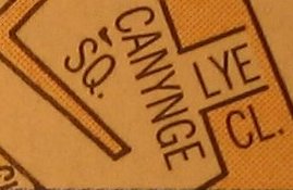
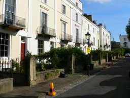
右の図はブリストルの A-Z 地図のごく一部です。ブリストルに行って Canyge 広場のあたりを歩いてみると、地図の下の写真のように、路地があるはずの場所も小奇麗な家が並んでいるのを目にするでしょう。
ライ路地は索引にも載っていません。変だと思いますか?これがイースターエッグです。(これは "トラップストリート" とも呼ばれます。)つまり、もしあなたがこれを複製したら、それを著作権者が複製だと証明するために使えるように仕込んであるものです。そのような理由がなければ、実在しない通りをわざわざ地図に描く理由がありませんから。
Google マップの例
(これらは Google がヨーロッパのデータを網羅するために Tele Atlas を使った時に、 Google マップに収録されたものです)
- Moat Lane, Finchley, London N3. Tele Atlas (Googleマップで使用されている)にこの存在しない道路があります。郵便局の住所データ(訳注: イギリスでは通りの名前によって住所を表す)にもなく、バルトロマイによるものでも、個人的な経験に基づくものでもありません。
- Kerbela Street, Shrewsbury, England. Google マップでソールスベリーの牧草地の農場の道を見ると、Kerbela Street が描かれていますが、これは実際にはこの場所にはなく、それどころか郵便局の住所録によると、ソールスベリーにはこのような名前の通りは存在しません。
- Torrington Place, Finchley, London N3, Arcadia Avenue N3 の終点にあるとされている場所です。Tele Atlas にはこの道が掲載されていますが、実際には存在しません。郵便局のデータにも実際に言ってみても存在しません。
- The Avenue, Finchley, London N3. Tele Atlas にはこの短い通りが完全に間違った角度で掲載されています。アパートの中を通りぬけていて、本当の場所から 60 m ほど離れた場所に描かれています。
- Warwick Road and Tudor Close - Sutton Coldfield shows up a good example of a Tele Atlas Easter egg. Or could it be that they planned to build the extension to Warwick Road and the Tudor Close spur but never did, in which case the detail for the map could have come from the planning stage. I'm not so sure though as the extension to Warwick runs through the back gardens of existing homes. Anyway, these roads don't exist in real life. Here is what the housing estate looks like on OSM as created from my GPX track.Blackadder 12:17, 3 Feb 2006 (GMT)
- Clapham Junction to Clapham Common a Tele Atlas Easter Egg showed a road running diagonal from the main intersection of Clapham Junction to Clapham Common, through several streets, rows of houses, and a department store. This easter egg was removed from Google maps at some point towards the end of 2006. The roads are now mapped on OSM.
- Oxygen Street doesn't exist in this part of Edinburgh
- Basildon Tele Atlas again: A couple of residential roads where the casual / unobservant visitor would be fooled into thinking they were in woodland with footpaths....--DrMark 13:18, 12 July 2008 (UTC)
- There are (at least) two mistakes/easter eggs in the map of Hilden (Germany):
- Grünewaldstraße - There appears a sidestreet "Grünewaldstraße" south to the street named "Grünewald". As the housenumbers suggest, this "Grünewaldstraße" is in fact named "Grünewald", too. In addition, the German postal code lookup server does not recognise a "Grünewaldstraße" in Hilden.
- Schwannenplatz - The street "Schwanenplatz" is (deliberately?) wrongly named "Schwannenplatz". The funny point with this is, that Google itself suggests the right name :-)
- St. Helens, UK shows "Hobbs Place" noted on the map, but on the satellite imagery you can see the road doesn't actually exist.
- U.S. Highway 9
is routed along New Jersey Route 52, 9th Street, and County Routes 619 and 623 around Great Egg Harbor Bay. While this may be due to the fact that the Beesley's Point Bridge (the span to the left of the Garden State Parkway) is closed indefinitely, the fact is that US 9 has not been officially rerouted off of the closed bridge.Google has since moved the US 9 markings to the Garden State Parkway, which is an alternative to the closed Beesley's Point Bridge but is not the official route. CrystalWalrein 14:31, 7 July 2010 (UTC)
- Rogaland, Norway: Wrongly named way In this map the part of Dublandsvegen which is secondary road is really called Opstadvegen. Also, many places Tele Atlas miss intersections or they have added where it shouldn't be. (Good motivation to make a better map here on OSM!)
- Bonn, Germany: Non-existing pathway. The "Galgenpfad" (german for "gallows-pathway", maybe some Tele Atlas joke?) does not exist (see blog post).
- Via Fabio Filzi, Mazara del Vallo (TP) - Italy. That road is at another place at all, correctly mapped in OSM, near the railway crossing.
In Langenstein, Saxony-Anhalt, Germany, there is a whole block of streets in a forest/on a mountain.fixed, apparently an error
Ordnance Survey vs Automobile Association

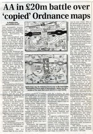
Ordnance Survey Maps sued the Automobile Association for copying their maps and diffusing the results to individuals as well as to third party mappers. Some 26 maps from AA were proven in court to be more or less direct copies of OS maps, or to incorporate data from OS maps. The AA was fined almost million pounds for infringement of copyright. Subsequently, the AA agreed to an out-of-court settlement of £20 million as compensation for other instances of copyright infringement. Compared to this sum, the AA has an annual cash flow of about £30 million.
Road signs that lie
There are also cases where the street signs are incorrect, but the maps are correct. For instance, the B550from Highgate in London to Whetstone (according to official sources at the Department for Transport, and according to OS, Bartholomew, Tele Atlas and Mapquest Maps). There are road signs at the Colney Hatch intersection on the A406 North Circular Road that shows it as the B550 in one direction and B505 in another.
Anachronisms
A stretch of road in northern New Jersey is known and mapped as New Jersey Route 24 along County Routes 517, 513, and 510, although a freeway was built with that designation between I-78 and I-287, and in 1993 the old Route 24 ceased to exist, although resident resistance has kept the old Route 24 signs standing since they know the road as such.
More anachronisms are found in Port Norris, New Jersey, where Strawberry Avenue is marked as County Route 680, High Street is CR 631 and Ogden Avenue is CR 632. These designations were removed in the late 1980s when the oyster industry collapsed, but the signs remain and the roads are mapped as such. An error between the TIGER imports, Tele Atlas and Navteq is the designation of County Routes 649 and 633 as County Routes 15 and 33 (and CR 728 as 33B); these were designations set forth by Cumberland County until standardisation under the current county route system. CrystalWalrein 02:46, 20 October 2008 (UTC)
その他の「すかし」の例
故意に誤った情報を入れること以外にも、地図作成者がコピーからの防御のために使うテクニックはあります。
デジタルなイースターエッグ
A class of Easter Eggs can be implemented by digital map providers who do not want their raw map data (vectors) copied. The lower bits of the geographic coordinates are mangled in some systematic way so that it would not be obvious to a user of the map, but could be used in a Copyright trial to show that the data had been copied.
For instance, if all the coordinates had a remainder of 3 when divided by seven, or were all displaced from their real coordinates by some small but real offset. So don't use digital map coordinates from proprietary sources even if you were to compare every intersection and shape point on the map!
地図製作型のイースターエッグ
Vertices trick(記号)。地物の形を定義している線でモールス符号を使うという地図作成法のトリックが使われていました。地物の縁にそって、一定の長さの区間ごとに点と線で表現することで、言葉を隠して配置する方法が一部の会社で使われていました。
森林に一見ランダムに見える樹木のシンボルを配置するテクニックが使われているという噂もあります。樹木を完全にランダムに配置するのではなく、何らかの暗号にもとづいてその間隔が調整されているというものです。
| ||||||||||||||

