JA:Tag:natural=glacier
![]()
英語版の記事の内容が分かる方は、翻訳の完成にご協力ください。このウィキの翻訳方法についての説明をお読みください。
現時点では、誰もこの記事の翻訳に取り組んでいないようですので、あなたが取り組めます。
![]()
 |
| 説明 |
|---|
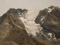
| 氷河。雪から自然に形成された氷の塊で、自身の重さで移動します。 |
| グループ: 自然 |
| 適用できる要素 |
| よく併用されるタグ |
| 状態:承認 |
| ツール |
A glacier is a body of ice that has formed by accumulation and subsequent densification of snow in an area where snow accumulation exceeds ablation and is continuously moving downhill under its own weight melting at the lower end and growing at the upper end. Glaciers occur in high mountain areas everywhere on earth as well as in polar regions. Some of the world's glaciers are very large (e.g., the Greenland ice sheet covers approximately 1,750,000 km²).
How to map

To map a small glacier you can just draw a line closing on itself along the outline of the glacier and tag it natural=glacier. To map large glaciers you can use Relation:multipolygon with the same tag.
When glaciers are connected to each other in their upper parts you can split them at the approximate watershed divides.
When you have no information on the geometry of the glacier you can also tag a node with natural=glacier and the glacier's name.
Mapping caveats
Glaciers are mostly mapped from aerial or satellite images which however is prone to errors. The following guidelines may help to avoid those.
- Outside polar regions glaciers are limited to high mountain areas. Mountains with elevations below a certain limit do not feature glaciers. This limit depends on latitude and local conditions. In the Alps mountains with less than 2500-3000m elevation usually are without glaciers. Around the Equator between around 30° N/S mountains lower than about 4000-4500m are free of glaciers. Glaciers on higher mountains can reach much lower altitudes at their lower ends though.
- To accurately map glaciers from imagery you usually need images from late summer where snow cover is at its minimum. Attempting to map glaciers from images taken earlier the year usually results in overestimation of the glacier area.
- The lower part of many glaciers is covered by a layer of loose rock material which can look quite similar to areas with loose material left by a retreating glacier. This often makes it difficult to determine where exactly the glacier ends. If in doubt look for signs of erosion (indicating there is no glacier any more) and the local topography (an active, moving glacier usually protrudes from the surrounding terrain).
- Glaciers can shrink and grow quite rapidly so when updating/improving previously mapped glaciers make sure you do not replace newer with older data.
A particular difficulty lies in distinguishing glaciers from seasonal and perennial snow. The following rules can be used to help make this distinction
- Glaciers always move so look for signs of movement, especially the formation of a tongue and end moraines at the lower end of the glacier or crevasses on its surface
- In summer the lower part of a glacier is usually free of snow, i.e. bare ice or ice covered with debris
- Snowfields are much more variable from year to year so comparing images from different years including ground level photographs can help
- Use your own or consult others' local knowledge
Tagging
| Tag | Description | Example |
|---|---|---|
| name=* | Name of the glacier. | |
| surface=* | Material covering the surface of the glacier | snow, ice, scree |
| direction=* | Direction of glacier movement | N,NE |
| glacier:type=* | Type of glacier | shelf, mountain, ice_tongue, icecap |
| glacier:status=* | Current behaviour of the glacier's front. | marked_retreat, slight_retreat |
For other possible tags see Proposed_features/Glaciers_tags. For special tagging conventions for glaciers in Antarctica see Antarctica/Tagging.
Rendering
| Mapnik | OpenCycleMap |
|---|---|
 |
No |
In the standard Mapnik style glaciers are rendered in bright blue with a thin dark outline starting at zoom=6. At zoom=8 and higher an additional 'wave' pattern is shown on the areas.
Examples

Perito Moreno Glacier, in Los Glaciares National Park, Argentina.
Glacier in the French Alps

