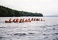
JA:激流スポーツ
![]()
ウォータースポーツの安全性と救助はよく知られた訓練コースの安全で管理された環境で訓練するのが一番です。ここに作成された地図情報は、明確に不完全であり作業中とするべきです。つまり、災害が地図から漏れている可能性があり、川の早瀬や区間も不正確で間違っている可能性があります。川の流れは変化しますが、激流地図は川の簡単な「調査」の後でしか作成されず、漏れがある可能性もあるので、よく洗練され完成されたカヤックのガイドブックでも防ぐことができません。もし川の動きや具体的にどのように川が流れているかの知識を持っていない場合は、絶対に地図に描かないでください。

|
| 説明 |
| カヌー、ラフティングなどの激流スポーツです。 |
| タグ |
![]()
英語版の記事の内容が分かる方は、翻訳の完成にご協力ください。このウィキの翻訳方法についての説明をお読みください。
現時点では、誰もこの記事の翻訳に取り組んでいないようですので、あなたが取り組めます。
![]()
OpenSeaMap は、カヌー、ラフティングなど激流スポーツのための情報を含みます。この仕事に関するプロジェクトへの参加は、 WikiProject Whitewater Maps を参照してください。
川
A river is a watercourse that is too wide to jump over it. Rivers are wide enough to be traveled by kayak or canoe. Take a waterproof GPS with (or packed waterproof), tie it firmly, and measure the exact course of the river. Note important points (set a track point, describe it by voice recorder, photo), and draw the map.
All rivers with width more than 5 meters has to be drawn by natural=water+water=river in addition to waterway=river.
If there is a tributary: please connect the two waterways together (not only the riverbanks).
| 対象 | 方法 | キーと値 | 記号 | 備考 |
|---|---|---|---|---|
| river | waterway=river + width=# + name=* +whitewater:section_grade=# + whitewater:section_name=* |
mainwaterline and asociated waterlines width of river in meter degree of difficulty name of whitewater section | ||
| water body | natural=water+water=river | rivers broader than 5m | ||
| island | multipolygon | Role: inner |


グレード
These are subjective in the good sense of the term. See the International Scale.
If you don't know a grade or can't decide set it to "unknown". If you don't know about river practise, don't map it at all.
| 対象 | 方法 | キーと値 | 記号 | 備考 |
|---|---|---|---|---|
| isolated rapid | whitewater:rapid_grade=# | Grade 0 | 1 | 2 | 3 | 4 | 5 | 6 | ||
| name of rapid | whitewater:rapid_name=* | |||
| sections | whitewater:section_grade=# | section of waterway=river (split in JOSM by <Strg-p>) Grade 6nbsp; 0 | 1 | 2 | 3 | 4 | 5 | 6 (see International Scale) Each section starts at a whitewater=put_in or whitewater=put_in;egress, | ||
| name of section | whitewater:section_name=* |
 グレード0
グレード0

 グレード1
グレード1 グレード2
グレード2 グレード3
グレード3 グレード4
グレード4 グレード5
グレード5 グレード6
グレード6


(White water classification follows its own subjectives rules not only described by these pictures, see International Scale)
危険区域
| 対象 | 方法 | キーと値 | 記号 | 備考 |
|---|---|---|---|---|
| Sluice | waterway=lock_gate | |||
| Weir | waterway=weir | together with whitewater=rapid_grade, or portage | ||
| waterway=canoe_pass | ||||
| Single hazard | waterway=hazard | |||
| Restricted section | section of waterway=river | |||
| Restricted Area | Nature protection, power station, etc | |||
| Blocks | ||||
| Hole | ||||
| Sandbank | ||||
| Nature reserve | natural=reserve | |||
| Description | whitewater:description=text | text of interest to canoeists |

Hole

Hole (Modell)

Blocks

Blocks


.jpg)

アクセス
| 対象 | 方法 | キーと値 | 記号 | 備考 |
|---|---|---|---|---|
| Put in | whitewater=put_in | always next to the riverbank | ||
| Egress | whitewater=egress | always next to the riverbank | ||
| Put in / egress | whitewater=put_in;egress | always next to the riverbank | ||
| How to put in | whitewater:put_in;egress=pier whitewater:put_in;egress=rubble whitewater:put_in;egress=sand_strand whitewater:put_in;egress=steps |
pier cobblestones sandy beach steps (stone, concrete) | ||
| Portage | whitewater=egress whitewater=portage_way + Aids whitewater=put_in |
egress way boat slide, boat carts, etc. put in | ||
| Parking | amenity=parking |

観光施設
| 対象 | 方法 | キーと値 | 記号 | 備考 |
|---|---|---|---|---|
| Camp site | tourism=camp_site + name=* |
|||
| wild camping permitted | tourism=camp_site + backcountry=yes |
|||
| Boat rent | shop=canoe_hire + name=* + building=yes |
|||
| WC | amenity=toilets | |||
| Shelter | amenity=shelter | |||
| Fireplace | tourism=picnic_site + fireplace=yes |
|||
| Restaurant | amenity=restaurant + name=* + building=yes + barbecue_grill=yes |
if barbecue available | ||
| Accommodation | tourism=hostel + name=* + building=yes |
+ a lot of additional informations |
A selection of additional values have been used in some areas with the whitewater key (see here for an analysis of values used). One used more than 100 times but not listed above is whitewater=portage_way. The key 'canoe' has been used by a few people (analysis) as has the key 'kayak' (analysis). Several suggestions have been made on the talk page for WikiProject_Whitewater_Maps for ways to ensure that this tagging scheme is compatible with tags of use for non-whitewater paddling, including the use of paddlecraft=put_in;egress (for flat-water or sea locations).
There are some existing/developing useful tagging conventions around access information - see details of: access=* or boat=* or canoe=* at Access, and boat=* at Key:boat and also a proposal at Proposed features/access restrictions 1.5.
There are also some existing/developing conventions about water coverage which may be useful (where, for example, an island may only appear occasionally). See Proposed_features/Water_cover.
激流地図

OpenSeaMap shows a Whitewater-chart. Use the "Sport"-layer in menu "View > Sport" with all rivers worldwide. Kayaks and canoeing tours are displayed by colours, according to their difficulty (starting in zoom level = 9). Put in and egress are marked, also hazards and portages. OpenSeaMap is the follower of the British WhiteWater Map. [1] [2]
For alternative methods of viewing rendered maps please see suggestions on WikiProject Whitewater Maps
マッピングされた地図の一覧
Please add the international list of mapped rivers
提案
- WikiProject_Whitewater_Maps/Proposals - 将来的な激流のタグ付けを開発するための全般的な提案。
- Proposed features/River Difficulty - 川の難易度のタグについての他の提案。放棄(無効)。
- Proposed features/Canoe - 関連する提案。
脚注
- ↑ Forth Canoe Club Open WhiteWater Map was a Mapnik rendering by Jonathan Riddell
- ↑ WW-Icons by Stella 2008-07-19