Key:area:highway
| Description |
|---|
| The shape of a highway area. |
| Group: highways |
| Used on these elements |
| Documented values: 9 |
| Useful combination |
| Status: de facto |
| Tools for this tag |
|
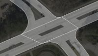
area:highway=* describes the shape (i.e. the two-dimensional outline of the area) of a highway, or parts of it. It is used as a form of micromapping in addition to the routable, linear way tagged as highway=*.
How to map
The tag is applied to a way closed as a polygon or to a multipolygon to mark the area of a highway.
Rendering
The tag is not currently rendered in the Standard layer (OSM Carto) on the OpenStreetMap website. It is rendered in the vector map of OsmAnd and OpenFietsmap (example). And geo.dianacht.de (https://osm.org/way/153916175). It is also possible to generate SVG images/maps at this website.
There is experimental project Straßenraumkarte Neukölln, which renders it and some other urban tags.
It's also rendered in Streets GL.
History of the tag
The tag was target of the following proposals of 2011 and 2015. Although no voting has (yet) taken place on these proposals, the tag is widely used. Some inconsistencies are yet to be resolved.
Classification
Pedestrian and bicycle areas
- area:highway=footway
- area:highway=cycleway
- area:highway=path
- area:highway=pedestrian
- area:highway=steps
Street areas
area:highway=*, when used on roads, should cover traffic lanes, bus lanes, and cycle lanes when these details added to the way corresponding to the area:highway, and should not cover shoulders, parking spaces, and sidewalks which are mapped separately.
Differentiation area:highway vs. area=yes on a highway
area:highway=* had been proposed to describe the non-routable, detailed shape of a (typically linear) highway. The tag requires the linear, routable direction of the highway mapped in addition as lines with highway=*.
area=yes on a highway=* describes a routable highway area on which the dedicated traffic can route omnidirectionally; i.e. from any point along the edge to any other. This is typical for pedestrian areas, or service areas where vehicles drive without prescribed lanes. The rationale is that routing engines should consider those omnidirectional objects in addition to nodes and edges in classical graph theory; thus no linear highway lines would be required within. However, as of 2019, OpenTripPlanner is the only OSM-based router that supports routing over areas. It does so by computing a visibility graph over the area. [1]
Inconsistencies
The area:highway=* tag, stemming from two different proposals, has unresolved inconsistencies:
- It remains unclear if the tag should be used for the full shape of the built highway, or split into functional sub-areas.
- For road segments with constant width mapping a polygon representation of linear road can be considered unnecessarily redundant to the linear highway mapping and a width=* tag and in violation of "one feature, one OSM element".
- Some mappers use area:highway=emergency, where they mean to describe road areas that are painted with white hatching that should be avoided in normal traffic flow, but have nothing to do with emergencies.
