Lane assist
This article describes the tagging to support a lane assistant.
Description
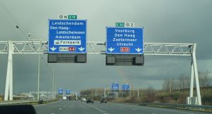
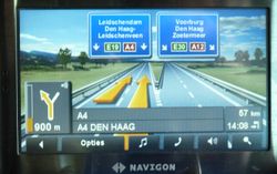
Lane assist helps a (car)driver into the correct lane, which is especially very useful at unfamiliar junctions. Lane assist has two flavours:
1. the arrows on the road, and sometimes on the side of the road (example: ![]() ), showing you the lay-out of the lanes. For navigational purposes the correct lanes should be highlighted.
), showing you the lay-out of the lanes. For navigational purposes the correct lanes should be highlighted.
2. the information signs above or next to the road, showing you the destinations of the lanes.
Tagging
Satellite photos (e.g. Bing) are very handy to view the arrows on the highways. To get this data in Openstreetmap you need lanes=* and turn:lanes=*. This :lanes page shows you how to tag the lanes.
Digital photos or videos, either taken by yourself or from an explicitly permitted source (such as street-level images from Mapillary and OpenStreetCam), are very helpful to acquire destination data. The wiki page for destination=* and the proposed extensions on the destination key Proposed features/Destination details describe how you can enter the acquired destination data into Openstreetmap.
Examples
Several examples are available at the moment. More examples will be posted here in the coming months. The examples combine both flavours of tagging for a lane assistant.


