London public transport tagging scheme/Map Challenges
Following the OSM Q&A in May, I'd like to pose a "Map Challenge" around applying the London public transport tagging scheme. At the meeting, the idea of "MissingMaps in London" was raised, and so this is an exploration of whether a "MissingMaps"-style approach is of interest to others. Obviously, in the future various challenges can be set. We could also explore whether the challenges can be "gamified", and perhaps the top-10 could receive a badge on their user page or another incentive?
Challenge 1: Fixing underground entrances, node[railway=subway_entrance]
According to the scheme London_public_transport_tagging_scheme#Station_entrances,
- underground stations should have entrances, and
- underground entrances should be tagged with "ref" and "wheelchair".
Overview
These maps shows the current situation:


(Click images to see larger image.)
Legend:
- Stations: small, solid purple dots (or purple station outlines in larger views)
- Anything else: an entrance (for details see below)
Map details
Here are some map details to explain the colour scheme:


Legend:
- Stations: small, solid purple dots and purple station outlines in larger views
- Anything else is a subway_entrance:
- No tagging: red, dashed border (thicker line)
- Some tagging: red, solid border, red fill, plus
- Green fill: Wheelchair tag has been added
- Green border: ref tag is present
- Solid border: name tag is present.
- Complete tagging: solid green border, green fill (and smaller symbol)
(I've tried to make the choice of colours as accessible as possible - leave a message if you would like a different scheme.)
Some examples:
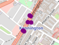
Station without nearby entrances
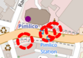
Station with nearby entrances. Entrances are not tagged at all.
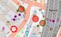
Station with nearby entrances, with a variety of tag states.
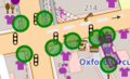
Station with fully tagged entrances.


An example for well-tagged node: http://www.openstreetmap.org/node/659654479
Interactive map
These interactive maps show the current state of entrances:
- Interactive map (showing all entrances, with above formatting scheme): Interactive map of station entrances (overpass-turbo.eu} (give it a moment to load, there's a lot of data)
- Interactive map (only showing complete entrances): Interactive map (overpass-turbo.eu)
You can use the maps to find areas that need work.
The Challenges
Challenge 1A: Add station entrances
As you see from the maps, many stations (purple dots) do not have a nearby entrance (esp. outside central London). The challenge is to add entrances, so that each station has at least one entrance.
Note: subway_entrances are "logical entities", i.e. stairs, escalator and lift all side-by-side only constitute one entrance. You could however add various ways from there, tagged differently.
Challenge 1B: Add tags for station entrances
As you can see from the maps, many stations do not have 'ref' or 'wheelchair' tags. The challenge is to add those tags. The 'ref' tag (although in the scheme) is not used a lot. However, the 'name' tag is used more. In "duck-tagging" fashion, I propose to add name tags as well. So a node should have these tags:
- railway=subway_entrance
- wheelchair=yes/no
- ref=1,2,3,... (a number if present)
- name=Exit 1,2,3,4..., Argyle Street (Exit + number + whatever it says above the exit)
Where an entrance does no have a ref/name, you could add
- note=entrance has no ref (date)
to show that it's been surveyed.
For the more experienced mapper, and for discussion
There are some further properties that the interactive maps do not monitor. For stations that are an exit/entrance only, I would suggest to add
- oneway=yes
- note=Exit only / Entrance only.
(The scheme recommends oneway, but this appears to be in conflict with Key:oneway which says that oneway applies to lines, so adding note to indicate direction.)
Key:entrance also mentions entrance=exit to be added for 'exit only'. This is no mentioned in the scheme, but it would make sense to add it:
- entrance=exit
For experienced mappers, You may also want to add the bicycle tags.
Changeset comment
Add #TFLMapChallenge to the changeset comment, to make edits more easily identifiable!
Stats
| date | stations | current number of entrances | within the current number of entrances: | |||
| node has wheelchair tag | node has ref tag | node has name tag | node has all tags (wheelchair/ref/name) | |||
| 3rd May 2017 | 708 | 337 | 156 | 31 | 157 | 8 |
| 9th May | 707 | 354 | 159 | 39 | 160 | 15 |
Note: Clearly each station should have at least one entrance. At the moment the number of entrances is less than half the number of stations. Also, all entrances should have wheelchair tag, while most (at least in Cenral London) should also have ref/name tags (some station entrances won't have refs).
Recent changes
Recent changes via overpass, as list:
[out:csv(::id,::user, ::timestamp, ::version, ::changeset,wheelchair,ref,name,note)][timeout:25];
{{rse=["railway"="subway_entrance"]}}
{{geocodeArea:"London"}}->.a;
{{myarea=(area.a)}}
(
  node{{rse}}{{myarea}};
);
(node._(changed:"{{date:7 days}}"));
out meta qt;
As map:
[out:json][timeout:25];
{{rse=["railway"="subway_entrance"]}}
{{geocodeArea:"London"}}->.a;
{{myarea=(area.a)}}
(
  node{{rse}}{{myarea}};
);
(node._(changed:"{{date:7 days}}"));
out meta qt;
Support available
User:Bjohas is watching the discussion page, so feel free to post questions/comments there. I'm happy to offer support in tagging, including support for new mappers. if you want to map in the field, e.g. using your phone, but you don't know how to use maps.me etc, get in touch. If the challenge is a goer, I'll also add weekly stats about progress. Bjohas (talk) 11:39, 4 May 2017 (UTC)