Mappa Mercia/Black Country
Introduction
The Mappa Mercia primary mapping project for 2009and 2010 is completion of the Black Country, ie Wolverhampton, Dudley, Sandwell, Walsall and their surrounding conurbations.
Mapping Party
West Bromwich Mapping Party 4/5 April 2009
The Black Country Cake
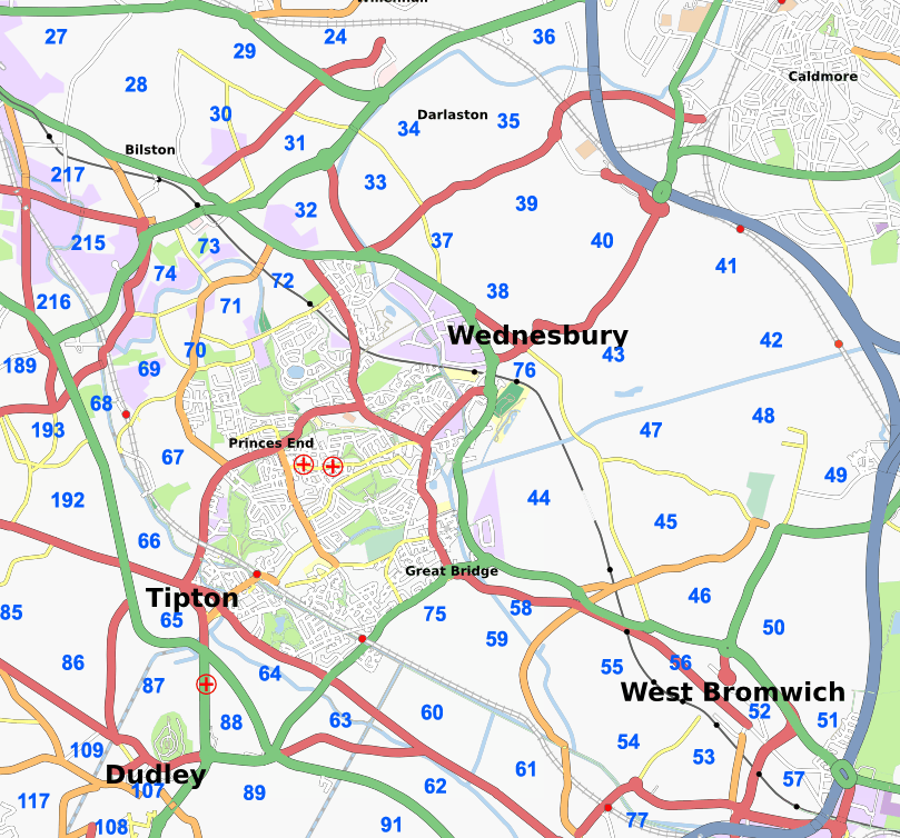
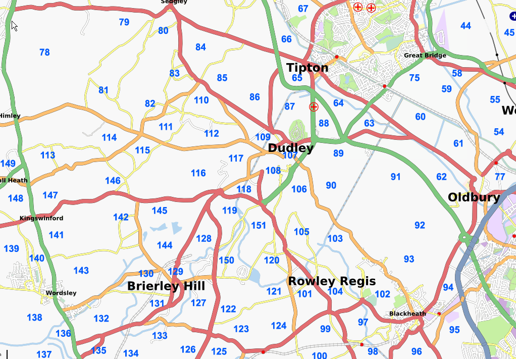
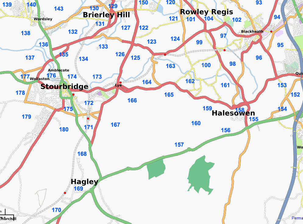
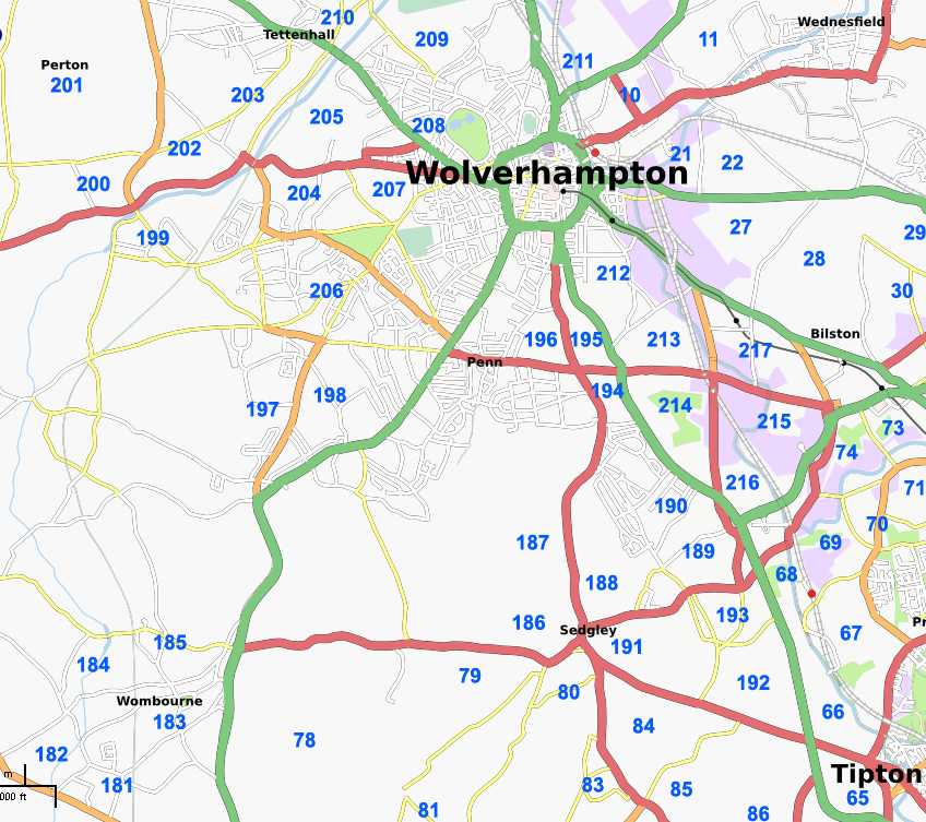
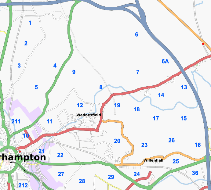
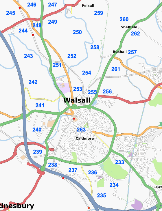
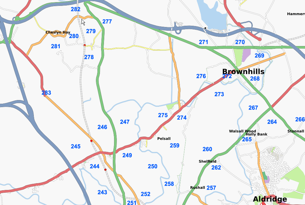
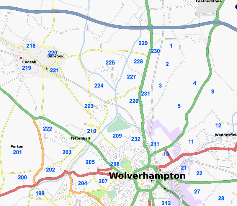
The following 4 images, based roughly on the four councils' boundaries, cover the remaining sections of the Black Country that require mapping as at Jan 2009. Our target is to have all 284 segments completed by Christmas 2009. See the table for progress. Click on the image for higher resolution versions, or click on the links below each map for close up maps of particular areas. The Sandwell map has been edited to indicate completions as of Nov 2nd, the rest will be updated shortly.
Dudley

Close-ups: NE | Central | S | NW
Sandwell

Walsall

Close-ups: W | SW | Central | NE
Wolverhampton

Other cake slices
Perton (201) and Codsall (218-221) are in South Staffordshire but appear on the Wolverhampton map(s) as they are part of the Wolverhampton postal district.
Cheslyn Hay (277-282) is part of the Walsall postal area, but is also in South Staffordshire. Part of the area appears on the Walsall maps, but the full area is available here.
Slices 6, 283 and the northern half of 6A are also in South Staffordshire and can be found on both the Wolverhampton maps and Walsall maps.
Stonnall (266) falls inside Staffordshire. It can be found on the Walsall map(s).
Wombourne (181-185) is also in South Staffordshire, and is partly visble on the Dudley map. The full village appears on this map.
Hagley (169-170) is in northern Worcestershire, and partly appears on the Dudley map. Both cake slices appear on this map.
Monitoring/Completion table
Please use the table below to record areas of the map you are planning to map and the completion details.
Dudley Sections
| Slice | Taken By | Completed? | Notes | Council Area |
|---|---|---|---|---|
| 65 | See also Sandwell | Dudley/Sandwell | ||
| 66 | Blackadder | See also Sandwell | Dudley/Sandwell | |
| 67 | Blackadder | Dudley | ||
| 68 | Blackadder | Dudley | ||
| 69 | Dudley | |||
| 70 | See also Wolverhampton | Dudley/Wolverhampton | ||
| 79 | See also Other Areas | South Staffs/Dudley | ||
| 80 | about 80% complete | Dudley | ||
| 81 | Dudley | |||
| 82 | Dudley | |||
| 83 | Dudley | |||
| 84 | Dudley | |||
| 85 | Dudley | |||
| 86 | Dudley | |||
| 87 | Dudley | |||
| 88 | Dudley | |||
| 89 | Brianboru | --Brianboru 13:48, 30 September 2009 (UTC) | Dudley | |
| 90 | Brianboru | --Brianboru 13:48, 30 September 2009 (UTC) | Dudley | |
| 101 | Dudley | |||
| 105 | Brianboru | --Brianboru 11:50, 20 April 2010 (UTC) | Dudley | |
| 106 | Brianboru | --Brianboru 11:50, 20 April 2010 (UTC) | Dudley | |
| 107 | Brianboru | Nearly complete | Dudley | |
| 108 | Dudley | |||
| 109 | Dudley | |||
| 110 | Dudley | |||
| 111 | Dudley | |||
| 112 | Dudley | |||
| 113 | Dudley | |||
| 114 | Dudley | |||
| 115 | Dudley | |||
| 116 | Dudley | |||
| 117 | Dudley | |||
| 118 | Dudley | |||
| 119 | Blackadder | Predominately complete. A bit of road to east of canal south of A461 needs adding still | Mapped as part of Canals mini-project May 2009 | Dudley |
| 120 | Brianboru | --Brianboru 11:50, 20 April 2010 (UTC) | Dudley | |
| 121 | Dudley | |||
| 122 | Dudley | |||
| 123 | Brianboru | About 90% complete | Dudley | |
| 124 | Brianboru | About halfway through this | Dudley | |
| 125 | Dudley | |||
| 126 | Dudley | |||
| 127 | Paul The Archivist/Blackadder | Merry Hill centre and Waterside. Mostly complete but more parking and other service roads at Merry Hill to add plus building footprint All done April 2010 --Brianboru 08:57, 20 April 2010 (UTC) | Mapped as part of Canals mini-project May 2009 | Dudley |
| 128 | Dudley | |||
| Looks about 90% complete | Dudley | |||
| 130 | Dudley | |||
| 131 | Blackadder | Brierley Hill town centre predominately complete. High street POI's needed plus some missing streets to north side of Church Street and around the church itself. | Mapped as part of Canals mini-project May 2009 | Dudley |
| 132 | Blackadder/EdLoach | Thought to be road complete | Mapped as part of Canals mini-project May 2009 | Dudley |
| 133 | Blackadder | Withymoor Village - Part competed. Needs another session. NCN54 runs through | Part mapped as part of Canals mini-project May 2009 | Dudley |
| 134 | Dudley | |||
| 135 | Dudley | |||
| 136 | Dudley | |||
| 137 | Dudley | |||
| 138 | Dudley | |||
| 139 | Dudley | |||
| 140 | Dudley | |||
| 141 | Dudley | |||
| 142 | Dudley | |||
| 143 | Dudley | |||
| 144 | Dudley | |||
| 145 | Dudley | |||
| 146 | Dudley | |||
| 147 | Dudley | |||
| 148 | Dudley | |||
| 149 | Dudley | |||
| 150 | Dudley | |||
| 151 | Dudley | |||
| 152 | Brianboru | --Brianboru 20:15, 1 July 2009 (UTC) | Dudley | |
| 153 | Brianboru | --Brianboru 07:30, 22 July 2009 (UTC) | Dudley | |
| 154 | Brianboru | --Brianboru 20:15, 1 July 2009 (UTC) | Dudley | |
| 155 | Brianboru | --Brianboru 07:30, 22 July 2009 (UTC) | Mostly park and golf course- already entered | Dudley |
| 156 | Brianboru | --Brianboru 08:53, 20 April 2010 (UTC) | Dudley | |
| 157 | Brianboru | --Brianboru 08:54, 20 April 2010 (UTC) | Dudley | |
| 158 | Brianboru | --Brianboru 11:55, 20 April 2010 (UTC) | Dudley | |
| 159 | Brianboru | --Brianboru 08:53, 20 April 2010 (UTC) | Dudley | |
| 160 | Brianboru | --Brianboru 08:54, 20 April 2010 (UTC) | Dudley | |
| 161 | About 90& complete | Dudley | ||
| 162 | Dudley | |||
| 163 | See also Sandwell | Dudley/Sandwell | ||
| 164 | Dudley | |||
| 165 | Dudley | |||
| 166 | Dudley | |||
| 167 | Dudley | |||
| 168 | Dudley | |||
| 171 | Dudley | |||
| 172 | Dudley | |||
| 173 | Dudley | |||
| 174 | Dudley | |||
| 175 | Dudley | |||
| 176 | Dudley | |||
| 177 | Dudley | |||
| 178 | Dudley | |||
| 179 | Dudley | |||
| 180 | Dudley | |||
| 186 | Dudley | |||
| 187 | Brianboru | Brianboru | Dudley | |
| 188 | Completed as part of Sedgley mapping party | Dudley | ||
| 191 | Completed as part of Sedgley mapping party | Dudley | ||
| 192 | Dudley | |||
| 193 | Dudley |
Sandwell Sections
| Slice | Taken By | Completed? | Notes | Council Area |
|---|---|---|---|---|
| 38 | Miked29 | OSSV tracing | Sandwell | |
| 39 | Miked29 | OSSV tracing | Walsall/Sandwell | |
| 40 | Blackadder | Sandwell | ||
| 41 | Complete | Sandwell | ||
| 42 | Complete | Sandwell | ||
| 43 | Complete | Sandwell | ||
| 44 | sherbourne | More or less complete | Sandwell | |
| 45 | sherbourne | More or less complete | Sandwell | |
| 46 | Complete | Sandwell | ||
| 47 | sherbourne | More or less complete | Sandwell | |
| 48 | Complete | Sandwell | ||
| 49 | 95% complete | Sandwell | ||
| 50 & 51 | sherbourne | Largely | Urban part done. Area to the North and West, bounded by B4041 and M5, is green space - country park/visitor farm/recreation ground etc. Will have footpaths. | Sandwell |
| 52 | Sandwell | |||
| 53 | Brianboru | Largely complete - could do with a final check | Sandwell | |
| 54 | Brianboru | Might have touched part of this whilst surveying 53 | Sandwell | |
| 55 | Complete | Sandwell | ||
| 56 | Thomas Wood | Some roads interpolated, many POIs photographed, some mapped up. | Sandwell | |
| 57 | Blackadder | blackadder 17:59, 6 April 2009 (UTC) | Sandwell | |
| 58 | Sward | Roads ging North off Great Bridge Street, South side not done. | Sandwell | |
| 59 | Sward | Mostly | I think the roads are complete. Classification and references needed. | Sandwell |
| 60 | Brianboru | --Brianboru 18:22, 20 April 2010 (UTC) | 90% complete by survey:10% industrial estate completed by OSSV tracing | Sandwell |
| 61 | Brianboru | --Brianboru 12:09, 20 April 2010 (UTC) | Sandwell | |
| 62 | Brianboru | --Brianboru 13:48, 30 September 2009 (UTC) | Sandwell | |
| 63 | 90% complete | Sandwell | ||
| 64 | 90% complete | Sandwell | ||
| 65 | See also Dudley | Dudley/Sandwell | ||
| 66 | See also Dudley | Dudley/Sandwell | ||
| 75 | Sward | Somewhat | Most roads traced, missing some off the A461 in the SW, A461/A41 in the NW. Road classification and references needed. | Sandwell |
| 76 | Sandwell | |||
| 77 | Brianboru | --Brianboru 18:45, 17 August 2009 (UTC) | Sandwell | |
| 91 | Brianboru | --Brianboru 18:42, 17 August 2009 (UTC) | Sandwell | |
| 92 | Brianboru | --Brianboru 17:09, 16 March 2009 (UTC) | Sandwell | |
| 93 | Brianboru | --Brianboru 19:15, 4 March 2009 (UTC) | Sandwell | |
| 94 | Brianboru | --Brianboru 17:13, 2 March 2009 (UTC) | Sandwell | |
| 95 | Brianboru | --Brianboru 07:39, 5 May 2009 (UTC) | Sandwell | |
| 96 | Brianboru | --Brianboru 07:39, 5 May 2009 (UTC) | Sandwell | |
| 97 | Brianboru | --Brianboru 21:07, 31 March 2009 (UTC) | Sandwell | |
| 98 | Brianboru | East of canal completed, some in the North to the West of the canal also done now | Sandwell | |
| 99 | Brianboru | --Brianboru 12:44, 24 October 2009 (UTC) | Sandwell | |
| 100 | Sandwell | |||
| 102 | Brianboru | --Brianboru 17:13, 2 March 2009 (UTC) | Sandwell | |
| 103 | Sandwell | |||
| 104 | Sandwell | |||
| 163 | See also Dudley | Dudley/Sandwell |
Walsall Sections
| Slice | Taken By | Completed? | Notes | Council Area |
|---|---|---|---|---|
| 6A | See also Other Areas | Walsall/South Staffs | ||
| 13 | Walsall | |||
| 14 | Walsall | |||
| 15 | Walsall | |||
| 16 | Walsall | |||
| 17 | Walsall | |||
| 18 | See also Wolverhampton | Walsall/Wolverhampton | ||
| 20 | Walsall | |||
| 23 | Walsall | |||
| 24 | Walsall | |||
| 25 | Walsall | |||
| 26 | Walsall | |||
| 32 | Miked29 | OSSV tracing | Wolverhampton/Walsall | |
| 33 | Miked29 | OSSV tracing | Walsall | |
| 34 | Miked29 | OSSV tracing | Walsall | |
| 35 | Miked29 | OSSV tracing | Walsall | |
| 36 | Miked29 | OSSV tracing | Walsall | |
| 37 | Miked29 | OSSV tracing | Walsall | |
| 39 | Miked29 | OSSV tracing See also Sandwell | Walsall/Sandwell | |
| 72 | See also Wolverhampton | Wolverhampton/Walsall | ||
| 233 | Blackadder | blackadder 18:14, 9 March 2009 (UTC) | Walsall | |
| 234 | Blackadder | blackadder 25 February 2009 | Walsall | |
| 235 | Blackadder | blackadder 1 March 2009 | Walsall | |
| 236 | Blackadder | blackadder 1 March 2009 | Walsall | |
| 237 | Blackadder | blackadder 23:26, 4 March 2009 (UTC) | Walsall | |
| 238 | Blackadder | blackadder 18:14, 9 March 2009 (UTC) | Walsall | |
| 239 | Blackadder | blackadder 22:00, 13 March 2009 (UTC) | Walsall | |
| 240 | Blackadder | blackadder 00:01, 15 March 2009 (UTC) | Walsall | |
| 241 | Blackadder | Walsall | ||
| 242 | Walsall | |||
| 243 | Walsall | |||
| 244 | Blackadder | Blackadder | Completed by ground survey | Walsall |
| 245 | Blackadder | Blackadder | Completed by ground survey | Walsall |
| 246 | Blackadder | Blackadder | Completed by ground survey | Walsall |
| 247 | Blackadder | Blackadder | Completed by ground survey | Walsall |
| 248 | Blackadder | Blackadder | Completed by ground survey | Walsall |
| 249 | Blackadder | Blackadder | Completed by ground survey | Walsall |
| 250 | Blackadder | Blackadder | Completed by ground survey | Walsall |
| 251 | Walsall | |||
| 252 | Blackadder | Blackadder | Completed by ground survey | Walsall |
| 253 | Blackadder | Part Completed by ground survey, some work still to do | Walsall | |
| 254 | Blackadder | Blackadder | Completed by ground survey | Walsall |
| 255 | Blackadder | Part Completed by ground survey, some work still to do | Walsall | |
| 256 | Blackadder | blackadder 21 February 2009 | Lime Pits Nature reserve (And Beacon Way running through it) needs surveying. | Walsall |
| 257 | Blackadder | blackadder 22:25, 1 April 2009 (UTC) | Some public footpaths to do | Walsall |
| 258 | Blackadder | Blackadder | Completed by ground survey | Walsall |
| 259 | Blackadder | Blackadder | Completed by ground survey | Walsall |
| 260 | Blackadder | Blackadder | Walsall | |
| 261 | Blackadder | blackadder 22:30, 1 April 2009 (UTC) | Some public footpaths to do | Walsall |
| 262 | Blackadder | blackadder 22:25, 1 April 2009 (UTC) | Some public footpaths to do | Walsall |
| 263 | Walsall city centre (inside the ring road). This area has been previously partly mapped by ground survey and then updated using OS OpenData StreetView. A full ground survey is still required | Walsall | ||
| 264 | Blackadder | blackadder 19:11, 19 March 2009 (UTC) | Some footpaths still need doing in the former sand and gravel pit within the park. | Walsall |
| 265 | Blackadder | blackadder 15:21, 25 March 2009 (UTC) | Walsall | |
| 267 | Blackadder | blackadder 16:21, 24 March 2009 (UTC) | Walsall | |
| 268 | Blackadder | Blackadder | Walsall | |
| 269 | Blackadder | Blackadder | Walsall | |
| 270 | Blackadder | Blackadder | Walsall | |
| 271 | Blackadder | Blackadder | Walsall | |
| 272 | Blackadder | Blackadder | Walsall | |
| 273 | Blackadder | Blackadder | Walsall | |
| 274 | Blackadder | Blackadder | Completed by ground survey | Walsall |
| 275 | Blackadder | Blackadder | Completed by ground survey | Walsall |
| 276 | Blackadder | Blackadder | Walsall |
Wolverhampton Sections
| Slice | Taken By | Completed? | Notes | Council Area |
|---|---|---|---|---|
| 1 | sherbourne | Yes, Oct/Nov 2009 | Wolverhampton | |
| 2 | sherbourne | Yes, Oct/Nov 2009 | Wolverhampton | |
| 3 | Wolverhampton | |||
| 4 | Wolverhampton | |||
| 5 | Wolverhampton | |||
| 7 | Wolverhampton | |||
| 8 | Wolverhampton | |||
| 9 | Wolverhampton | |||
| 10 | Wolverhampton | |||
| 11 | Wolverhampton | |||
| 12 | Complete | Wolverhampton | ||
| 18 | See also Walsall | Walsall/Wolverhampton | ||
| 19 | Wolverhampton | |||
| 21 | Wolverhampton | |||
| 22 | Wolverhampton | |||
| 27 | Wolverhampton | |||
| 28 | Wolverhampton | |||
| 29 | Wolverhampton | |||
| 30 | Wolverhampton | |||
| 31 | Wolverhampton | |||
| 32 | See also Walsall | Wolverhampton/Walsall | ||
| 70 | See also Dudley | Dudley/Wolverhampton | ||
| 71 | Wolverhampton | |||
| 72 | See also Walsall | Wolverhampton/Walsall | ||
| 73 | Wolverhampton | |||
| 74 | Wolverhampton | |||
| 189 | Wolverhampton | |||
| 190 | Wolverhampton | |||
| 194 | Brianboru | OSSV edits | Wolverhampton | |
| 195 | Completed by Xoff | Wolverhampton | ||
| 196 | Brianboru | OSSV edits | Wolverhampton | |
| 197 | Wolverhampton | |||
| 198 | Brianboru | OSSV edits | Wolverhampton | |
| 199 | EdLoach | Roads completed 25th October 2009 | Wolverhampton | |
| 200 | EdLoach | Roads completed 24th October 2009 | Wolverhampton | |
| 202 | EdLoach | Roads completed 24th October 2009 | Wolverhampton | |
| 203 | EdLoach | Roads completed 24th October 2009 | Wolverhampton | |
| 204 | EdLoach | Roads completed 25th October 2009 | Wolverhampton | |
| 205 | EdLoach | Roads completed 10th May 2009 | University campus and school grounds make up large spaces. | Wolverhampton |
| 206 | Wolverhampton | |||
| 207 | EdLoach | Roads completed 25th October 2009 | Wolverhampton | |
| 208 | EdLoach | Roads completed 19th July 2009 | Area between canal to NW, 209/232, A41 and Ring Road. | Wolverhampton |
| 209 | EdLoach | Roads completed 19th July 2009 | Area bounded to west/north/east by canal, and 208/232. | Wolverhampton |
| 210 | EdLoach | Roads completed 24th October 2009 | Wolverhampton | |
| 211 | Wolverhampton | |||
| 212 | Brianboru | --Brianboru 12:23, 20 April 2010 (UTC) | Wolverhampton | |
| 213 | Brianboru | --Brianboru 17:00, 27 April 2010 (UTC) | Will attempt to complete this with OSSV tracing | Wolverhampton |
| 214 | Brianboru | OSSV | Wolverhampton | |
| 215 | Wolverhampton | |||
| 216 | Wolverhampton | |||
| 217 | Wolverhampton | |||
| 218 | Wolverhampton | |||
| 219 | Wolverhampton | |||
| 220 | Wolverhampton | |||
| 221 | Wolverhampton | |||
| 222 | EdLoach | Roads completed 24th October 2009 | Wolverhampton | |
| 223 | EdLoach | Roads completed 24th October 2009 | Boundary with 224 taken as the railway line | Wolverhampton |
| 224 | EdLoach | Roads completed 2nd January 2010 | Wolverhampton | |
| 225 | EdLoach | Roads completed 2nd January 2010 | Wolverhampton | |
| 226 | EdLoach | Roads completed 2nd January 2010 | Wolverhampton | |
| 227 | EdLoach | Roads completed 2nd January 2010 | Wolverhampton | |
| 228 | EdLoach | Roads completed 2nd January 2010 | Wolverhampton | |
| 229 | EdLoach | Roads completed 2nd January 2010 | Wolverhampton | |
| 230 | Wolverhampton | |||
| 231 | Wolverhampton | |||
| 232 | EdLoach | Roads completed 19th July 2009 | Area between 208, 209, canal and Stafford Road. | Wolverhampton |
Sections just outside West Midlands
| Slice | Taken By | Completed? | Notes | Council Area |
|---|---|---|---|---|
| 6 | South Staffs | |||
| 6A | See also Walsall | Walsall/South Staffs | ||
| 78 | South Staffs | |||
| 79 | See also Dudley | South Staffs/Dudley | ||
| 169 | Worcs | |||
| 170 | Worcs | |||
| 181 | South Staffs | |||
| 182 | South Staffs | |||
| 183 | South Staffs | |||
| 184 | South Staffs | |||
| 185 | South Staffs | |||
| 201 | Made a start on Perton (used to live there) before finding this page, but now live in Essex so can't guarantee to do any more. --EdLoach 10:59, 11 March 2009 (UTC) | South Staffs | ||
| 266 | Blackadder | blackadder 17:47, 16 March 2009 (UTC) | A few unclassified roads between Stonnall and Shenstone still need traces (currently from NPE) | Staffs |
| 277 | South Staffs | |||
| 278 | South Staffs | |||
| 279 | South Staffs | |||
| 280 | South Staffs | |||
| 281 | South Staffs | |||
| 282 | South Staffs | |||
| 283 | South Staffs |