Marikina Mapping Party/Planning
Jump to navigation
Jump to search
This page is for coordinating the planning, organizing, preparations, and logistics of the Marikina Mapping Party.
Planning maps
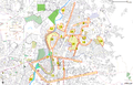
Proposed Cake Slices
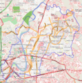
No Name Roads


Before the event
Announcements
- We have a shorturl for the Wiki page: http://bit.ly/MarikinaMappingParty (case-sensitive!)
- http://bit.ly/marikinamappingparty works also
- Facebook. A Facebook event page was created at the OSMPH fan page. This will serve as the main RSVP page (since this Wiki is too geeky for newbies).
- Online announcements. This event was announced/posted online at the following places:
- Firefly Brigade yahoogroups - c/o maning
- Philippine Cycling Network yahoogroups - c/o maning
- waypointsdotph yahoogroups - c/o maning
- marikinavalley.com - c/o maning
- WebGeek Philippines Forum - c/o kzap
- SEO Philippines Forum - c/o kzap
- PHP User-Group Philippines Forum - c/o kzap
- Pinoy MTBiker Forum - c/o maning
- Skyscrapercity forums - c/o seav
- Please add links so that we can follow up questions or replies on those forums.
- Posters. A poster was prepared by seav and printed and posted on several barangay public bulletin boards by maning.
Sponsorships and marketing
- There is a potential sponsor (Garmin retailer) but nothing concrete yet. No response until today Maning 11:51, 11 March 2010 (UTC)
- UPDATE: NAVCO (a local GARMIN Nuvi retailer) will offer limited 30% discount to mappers who will attend the event.
During the event
- Schedule/programme
- Rough outline with times and venue already on the main wiki page.
- Materials
- Banner - looking for sponsorship; design not yet done
- Freebies? unofficial OSM license card? Looking for sponsorship
- Food and refreshments? Nothing will be served :( KKB
Morning briefing @ Blue Wave
- Venue. Jollibee
- Materials
- I think we should make simple pamphlets to give newbies a rough introduction to OpenStreetMap and the scheduled activities for the day. --seav 04:23, 9 March 2010 (UTC)
- I'll try to make one, time permitting. (Busy, busy!) --seav 05:31, 17 March 2010 (UTC)
- Done: File:OSM-PH Flyer 2010-03-19.pdf --seav 02:12, 19 March 2010 (UTC)
- I'll try to make one, time permitting. (Busy, busy!) --seav 05:31, 17 March 2010 (UTC)
- I think we should make simple pamphlets to give newbies a rough introduction to OpenStreetMap and the scheduled activities for the day. --seav 04:23, 9 March 2010 (UTC)
Field surveying
- Cake sliced already. See the main wiki page.
- GPS units available - 2 from the gpstogo, 3 etrex c/o Sorbi
- walking papers - maning will print
Online editing @ SM City
- Venue. SM City Marikina - sent an email request to use the Mall Activity Area. Will follow-up within the week. If request is denied, we can always use a cafe or the foodcourt to do the edits.
- Materials
- Laptops are needed
- Backup mobile internet? Is SM's wifi reliable?
Evening socials
- Venue. None yet.
- Activities. Anything goes. :-)