Ms:2015 Nepal earthquake
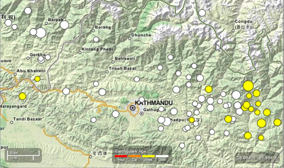
Magnitud gempa bumi di Nepal (Wikipedia) adalah 7.8 dan berlaku pada 11.56 waktu tempatan, Sabtu 25hb April 2015, dengan pusat gempanya lebih kurang 29km (18 batu) timur tenggara dari Lamjung dan 81km (50 batu) barat utara dari Kathmandu, Nepal. Lokasi pusat gempa adalah di 28.165N, 84.725E epicentre location.

Anyone can consult free OpenStreetMap Online maps, Routing services or even bring the Map on their Smartphone. For crisis like this Nepal earthbrake, contributors from around the world digitize rapidly the data from Satellite imagery to support the humanitarian organizations that deploy in the affected countries.
Our goal is to contribute to humanitarian relief by providing rapidly a detailed and accurate map (i.e., road network, villages, buildings, etc.) to support the humanitarian organizations. These services help locate people at risk rapidly, and facilitate the delivery of goods and services to remote areas.
- OSM Tasking Manager to coordinate the mapping by the contributors
- Communication with the contributors
- Follow discussions on HOT Email list
- Live #hot IRC Channel discussions with the Support Team (Use a nickname and type at the bottom of the screen to discuss with others.)
Coordination
Pierre Béland from abroad (GMT-4)
Nama Raj Budhathoki and Kathmandu Living lab colleagues (GMT+5:45)
email contact : activation@hotosm.org
The OSM servers, Editing tools and Map and Export products let us offer a variety of free Map and Export services to the humanitarian community. The OSM community support to these Activations is also impressive. The Humanitarian OpenStreetMap Team assures the bridge between the OSM community and the humanitarians. We partner with various international organizations and take the responsability to map quickly various areas while the international organizations deploy in the field to respond to this epdidemy and support the local communities.
Map and Data Services
About OpenStreetMap
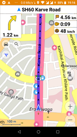
OpenStreetMap offers an online map and spatial database that is updated by the minute. Various online maps are based on OpenStreetMap, including Navigation tools such as OSRM. Tools and services allow data extracts for GIS specialists, routable data for Garmin GPS, GPS navigation with smartphones and other device-compatible downloads. With an Internet connection, regular syncing is possible, because there is open access to the community-contributed data as it comes in. Also bulk with downloads of OpenStreetMap data are ideal for use offline. In addition, maps can be printed to paper, if needed.
Browse the Activation Area to get a feel for the data that is currently available. Different map styles, including a special Humanitarian style, can be selected on the right side of the screen. Though some data may not render (appear) on the online map, it can be exported from the underlying database for other uses requiring more detail(See export section below).
Paper Maps
Large poster-size maps and letter-size paper atlases of custom areas can be printed:
- FieldPapers Paper Maps with grid for field survey or general navigation purposes,
- MapOSMatic Large Paper Maps with grid, street index and POI, good for command centers, hospitals, etc.
Exporting OpenStreetMap data
Frequent updates
| OSM Format | ShapeFiles for GIS softwares | Offline Navigation on Small Devices | |
|---|---|---|---|
| Daily updates | .pbf | Shapefile(Esri) 13 Thematic Layers |
.obf OSMAnd Garmin IMG file |
| 30 minutes updates by geofabrik | .pbf | Shapefile(Esri) | Garmin IMG file |
All files updated with latest OSM data 2015-04-26 00:49:00 GMT
Daily OSM updates in various formats are provided by the Humanitarian OpenSteetMap Team volunteers.
Geofabrik 30 minutes updates are in this directory of files. This contains the raw OSM data, as well as files formatted for Garmin devices, and several other file formats.
One of our volunteers has published a OSMand file which is updated every 30 minutes from the latest OSM data.
Information about the various OSM export formats
- OSM.pbf : These compressed OSM files are recognized by various GIS softwares.
- Shapefile : This data can be imported to GIS software, such as Quantum GIS or ESRI ArcGIS for Desktop.
- OSMAnd.OBF : OSMAnd / Android and iPhone Offline map and navigation
Note: launched 2015-04-19, the first iPhone version does not yet integrate all the functionalities of the Android version.- » Android File manager: Move the obf file from the download to the OSMAnd directory
- LearnOSM Tutorial Configure OSMAnd, and Offline map navigation
- How to use Voice Navigation
- GPS.IMG : Garmin GPS format
- » Rename the IMG file to gmapsupp.img and move it to the Garmin directory of the GPS card
- Other Mobile devices : See other Mobile device products.
HOT Response
Ongoing updates about this activation are posted on the HOT mailing list
Coordination and discussion may also happen on HOT's IRC Channel (direct link) or Mumble Server
Mapping tasks are being created and can be found on the HOT Tasking Manager
Overview of tasks and imagery coverage on uMap
Summary statistics of all tasks can be on at [1]
| Job No. | Location | What to map | Imagery expiration | Task Mapping Status | Task Validation Status |
|---|---|---|---|---|---|
| Job 994 (priority) | North of Kathmandu and remote mountain areas | roads only | N/A | In Progress | In Progress |
| Job 995 | East of Kathmandu and remote mountain areas | roads only | N/A | In Progress | In Progress |
| Job 1001 (priority) | West of Kathmandu and remote mountain areas | roads only | N/A | In Progress | In Progress |
| Job 1002 | North West of Kathmandu - Manaslu Conservation Area | roads, villages, buildings | N/A | In Progress | In Progress |
| Job 1004 | South West of Kathmandu | roads | N/A | In Progress | In Progress |
| Job 1006 | North of Narayangadh and east of Pokhara | Residential areas and buildings | N/A | In Progress | In Progress |
| Job 190 | Kathmandu Valley, includes more imagery | buildings only | N/A | In Progress | In Progress |
| Job 1003 | North of Dunche, includes more imagery | detailed mp | N/A | In Progress | Completed |
http://tasks.hotosm.org/project/1003
Improving the map
The Humanitarian OpenStreetMap Team in the early stages of a response. At this time big picture items like reviewing/improving the road network will help, but that is also most prone to edit conflicts so please save often and understand in the busy time like this you might encounter edit conflicts.
Any local knowledge like infrastructure, buildings or road names that you know and can positively identify, are extremely helpful to responding organizations.
The general Nepal remote mapping guide may be useful for help with identifying Nepalese features
Mapping roads is a high priority, the Nepal roads page for proposed road conventions or guidelines for road categorization is a good reference.
OpenStreetMap is a editable map, so we can improve it if there's anything missing/wrong (Beginners' guide). This is particularly useful if you have any local knowledge or you can survey things on-the-ground (names of streets etc)
People who have local knowledge but do not know how to edit OpenStreetMap are still vital to our aid efforts. You can share your local knowledge with the OpenStreetMap "Notes" feature. This lets you drop a marker and attach a note with information about the location/building/road that an experienced OSM mapper will then put in the OSM database. For simple instructions on how to share your knowledge with our mappers please see this quick guide to using notes:
How to easily share local knowledge with OSM Notes
Imagery and Reference Maps
Imagery Requests
Fresh and archive satellite imagery is being requested through international activations charter and imagery providers. HOT has identified areas that need high resolution imagery for both base mapping and damage assessment. Areas requested are highlighted in bright blue on this map:
http://umap.openstreetmap.fr/en/map/hot-imagery-coordination_37804#9/28.0623/85.2251
Bing
Bing imagery coverage as of 2015-04-25 with TM #994 and #995 overlay. (coverage source TMS: http://ant.dev.openstreetmap.org/bingimageanalyzer/tile.php/{z}/{x}/{y}.png)
Mapbox
For some of TM #1001 the Bing imagery may be cloudy or unavailable, MapBox has coverage, but not at all zoom levels.
Public domain topo maps
There are two sets of public domain topographic maps available which cover large portions of Nepal. Both sets are 1:250,000 scale, which means they are only really useful for adding place names, of which the maps list thousands. Before we manually copy in place names from these maps we will manually merge in the GNS place names for the area, which will cut down on some of the work. After that is done, we will create task manager jobs to go through and systematically enter all of the place names on these topographic maps.
| Layer | JOSM TMS Url | View |
|---|---|---|
| US Army Map Service (AMS) | tms[15]:http://mapwarper.net/layers/tile/345/{zoom}/{x}/{y}.png | View online |
Other Links and Data
World Pop 100M gridded population for Nepal - currently being updated
www.kleineisel.de Topographic OSM map for Garmin devices with contours
Nepal Topo Maps 1:25,000 This site contains a bunch of topographic maps. They are copyrighted so we cannot use them without permission from the creators. The copyright is His Majesty's Government of Nepal, Survey Department. Please coordinate on the HOT mailing list before sending any requests to the org to avoid sending multiple requests.
Write-ups and in the News
25-APR-2015: Articles on ReliefWeb by Shadrock Roberts describing all the DH group efforts

