Project of the week/2011/Jan 26
Buildings
.jpg)

Adding buildings to OpenStreetMap has been difficult in the past. Collecting a GPS trace of a building yields poor results because the building interferes with GPS reception. But buildings can be interesting to have on a map. Large collections of buildings in cities can look very impressive. Lone buildings in remote areas can be important landmarks for navigation. Or a shelter from bad weather.
There are more than 28 million buildings in the OpenStreetMap database. Recent donations to OpenStreetMap contributors of aerial imagery that permits deriving OSM objects without restriction have made mapping buildings practical in more parts of the world.
The Project of the Month is to add local buildings to the map.
Tagging suggestions
Buildings are mapped as areas in OpenStreetMap. As always, OSM contributors are able to provide the best, most-accurate, most-up-to-date data when they contribute data from places they visit every day or every week.
Required tags
The only required tag for a building is
It is acceptable to tag buildings with a more descriptive building tag, such as building=house. Fewer than three percent of OSM buildings use these more-descriptive tags, and it remains unclear what granularity of different values should go into building values as opposed to other tags (existing tags) on the same area. Despite this, a recent Mapnik rendering change (Feb 2011) means we're now showing building=house and building=residential in a lighter shade than other building tags example, so we can expect use of those values to increase. The rendering change is under discussion however.
Recommended tags
Address information for buildings should be added where they are known.
Some buildings have names
If the building has only a single tenant or business that name is often applied to the building.
Results
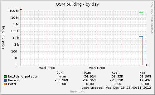
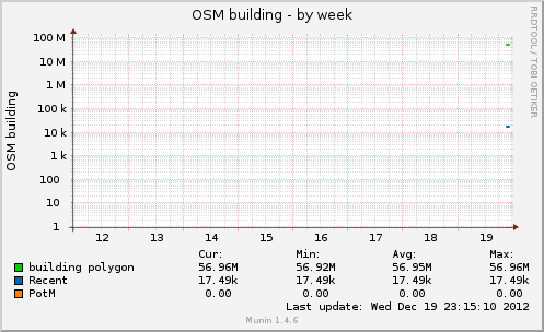
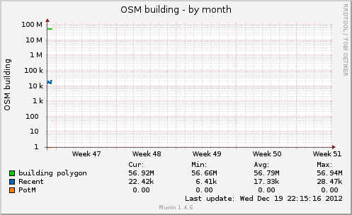
These graphs show the number of buildings* in the OpenStreetMap database and are updated approximately once per hour.
http://rweait.dev.openstreetmap.org/osmbuilding-day.png
http://rweait.dev.openstreetmap.org/osmbuilding-week.png
http://rweait.dev.openstreetmap.org/osmbuilding-month.png
- The "recent" line shows the number of objects added recently. It is a rough indication of PotM activity over the last little while, nominally an hour. The "PotM" line indicates the start and end of the project period.