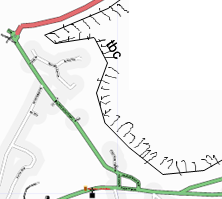
Proposal:Edge of known local universe
| Edge of known local universe | |
|---|---|
| Proposal status: | Abandoned (inactive) |
| Proposed by: | * |
| Tagging: | tbc=[[Tag:tbc=<comment>|<comment>]] |
| Statistics: |
|
| Rendered as: | hatched strip |
| Vote start: | * |
| Vote end: | * |
('tbc' is 'to be continued' e.g. tbc='housing estate here not mapped yet')
If you set out to map a place systematically (as I did with Chapel-en-le-Frith and Fulbourn recently), it's rarely possible to do it all at once. It would be useful to know the where the edge of the mapped area is and what areas remain within the local area. This would be removed as detail is added. This offers a hint to contributors as to where fruitful additions could be done, and to the consumer to show that what might look superficially complete actually isn't.
Think of how the OS shows the edge of national parks - that's the kind of annotation I have in mind.
See also Towards in Proposed_features
--User:David.earl 11 Oct 2006
Discussion
- I don't think having a border around the mapped area will work at all once areas really start to merge together. If the symbol is used at the end of each road that continues beyond what is mapped then a clear outline of where people have been would be formed by the collection of these symbols. Ben. 03:28 3rd February 2007 (UTC)
- The point is to remove these areas as mapped areas join up. user:David.earl 19 Feb 2007
- Could we not be more specific and label each way that continues beyond its current end point? (As suggested in other places on the proposed features list) The cluster of arrows (or whatever symbol) would be most dence around the edge of the known universe so have a similar effect. I do actually draw a line around the area I edit and use it in just this way, but I think that Its best if it just stays on my computer, rather than be uploaded to OSM itself. Ben. 00:47 20th February 2007 (UTC)
- I for one think this is a good proposal: the point being to positively inform others that they are looking at an area that has been comprehensively mapped. I believe it would be impractical to have a system such as Ben's which would appear to inform others of areas which have not been comprehensively mapped. Longwayround 13:52, 6 January 2008 (UTC)
- In jest someone might write 'tbc=here be dragons" ;) ShakespeareFan00 16:39, 23 October 2007 (BST)
- Something is definitely needed.
- Levels should be considered. For example main roads only, through roads only and so on.
- It should be applicable to linear, area and point features.
- It should be applicable to any linear feature so the side hatching is a good idea. Then it can be rendered beneath everything else so that the linear feature type can still be seen. For road types I suggest colour coding as per the road type not mapped.
- When people start using this feature consequently, there will be more borders of the known universe than streets, because between streets there will always be unmapped buildings...
With every street drawn through and empty area, there will be two more areas to be drawn to mark the emptyness on both sides... that will cause a huge amount of moved nodes to divide the empty area. Empty areas are identified by emptyness. That is enough! This proposal is stupid!--Lulu-Ann 21:24, 27 June 2008 (UTC)
Malcolm Boura 20:03, 12 May 2008 (UTC)
