Proposal:Key:pitlatrine
| Pit Latrine | |
|---|---|
| Proposal status: | Obsoleted (inactive) |
| Proposed by: | SeanBlaschke |
| Tagging: | pitlatrine=yes |
| Applies to: | |
| Definition: | Toilet is a latrine, a receptacle (as a pit in the earth) for use as a toilet |
| Statistics: |
|
| Draft started: | 2011-10-22 |
Note: this proposal has been superseded by toilets:disposal=pitlatrine
Proposal: We are trying to map pit latrines, with various attributes. The current, closest related item - 'toilet' - fits a very narrow use case and does not cover the types of feces receptacles we require to map and which are the most common type of toilet in the world. The proposed tag does not exist, is not a proposal in progress, or is a rejected tag. Pit latrines are a destination in itself, with over a billion worldwide. Size of latrines can be be individual (2x2m), or larger latrine stances (10X2m). It can be used for research (for example, UNICEF is interested in latrine to pupil ratios in schools), and even assist in route planning (the need to know where public restrooms can be very important).
Description
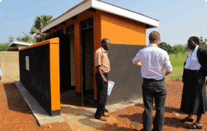
pitlatrine=yes denotes that the amenity=toilets are Pit Latrines. Pit Latrines are "A hole or pit into which human excrement is deposited. Known as an outhouse or privy when sheltered by a small building."
Usage
Use this tag in combination with other tags, most frequently in combination with amenity=toilets.
Implications
A value of no (or no value) implies the amenity=toilets are seatable, can be flushed and are connected to a sewage system.
Tags to use in combination
Standard combination tags (all proposed)
Discussion
I propose using key=toilets:type in conjunction with the values "flush,pit,chemical,bucket".
Then additionally, ventilation =yes and composting=yes can be added to the feature.
-worldwidewolford 2013-04-02
Examples
Related terms:‹ pitlatrine ›
