Proposal:AreaAdress
| Relation:areaAddress | |
|---|---|
| Proposal status: | Draft (under way) |
| Proposed by: | Hno |
| Tagging: | type=areaAddress |
| Applies to: | |
| Definition: | areaAddress is a method to tag named squares, junctions, open fields and sites, in the whole areas, independently from the streets nearby. |
| Statistics: |
|
| Rendered as: | text |
| Draft started: | 2012-04-08 |
Reason for this proposal
Sometimes houses have in the address instead of a street's name the name of an area. In most cases this area can be tagged by naming a way around with the area's name. But there can be exceptions, when the roads, the buildings belonging to the area can be reached by, are named differently.
These areas can be open fields or sites, but big named junctions can be tagged with this method as well.
For better understanding see also Examples.
Tagging
An areaAddress relation is made of two other relations:
- an associatedStreet relation
- a multipolygon
associatedStreet
The associatedStreet relation is used to connect the addresses with their access roads.
Tags
The tag type=associatedStreet is mandatory.
Other tags, including name=*, are not neccessary.
Members
| Tag | Number | Role | Description |
|---|---|---|---|
| one or more | street | The roads the houses with the area's address can be reached by; in use with junctions the road segments being part of the junction | |
| house | The addresses belonging to the area. |
Multipolygon
The multipolygon relation is used to define the area.
Tags
The tag type=multipolygon is mandatory.
Other tags, including name=*, are not neccessary.
Members
| Tag | Number | Role | Description |
|---|---|---|---|
| one or more | Ways being part of the areas boundary |
areaAddress
The areaAddress relation connects the houses and their access roads with the area.
Tags
| Key | Value | Description | Recommendation |
|---|---|---|---|
| type | areaAddress | Definition | mandatory |
| areaAddress | area | an area with buildings within residential or industrial areas | mandatory |
| open_fields | an area outside of the residential area with a few buildings | ||
| junction | a named junction | ||
| name | any | the area's name | mandatory |
Examples
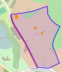
Open fields #1
- Tagging at the moment
- The blue framed area are open fields called Äußerer Pfühl.
- The orange coloured buildings have the area's address (e.g. "Äußerer Pfühl 17").
- The red marked road is the orange buildings' access road. Although it is tagged with name=Äußerer Pfühl at the moment, the road itself has the name Buchernsteige.
- Using the areaAddress relation
Relation Tags Role Members associatedStreet type=associatedStreet street Red marked track, tagged with name=Buchernsteige house Orange buildings, tagged with addr:street=Äußerer Pfühl multipolygon type=multipolygon Elements of the blue boundary of the area areaAdress type=areaAddress areaAdress=open_fields name=Äußerer Pfühl The associatedStreet and the Multipolygon relations
Open fields #2
- Tagging at the moment
- The blue framed area are open fields called Frosch.
- The orange coloured buildings have the area's address (e.g. "Frosch 3").
- The red marked road is the orange buildings' access road called Trappensee. By the fact that this road is the only orange buildings' access road, there is no highway tagged with name=Frosch.
- Using the areaAddress relation
Relation Tags Role Members associatedStreet type=associatedStreet street Red marked highway, tagged with name=Trappensee house Orange buildings, tagged with addr:street=Frosch multipolygon type=multipolygon Elements of the blue boundary of the area areaAdress type=areaAddress areaAdress=open_fields name=Frosch The associatedStreet and the Multipolygon relations
Areas within residential areas
A more famous example is the city center of Mannheim
- Tagging at the moment
- The blue framed area is called Bildungscampus by the fact, that there are only buildings with educational use.
- The orange coloured buildings have the area's address (e.g. "Bildungscampus 3").
- The red marked roads are the orange buildings' access roads. They are all named differently.
- Using the areaAddress relation
Relation Tags Role Members associatedStreet type=associatedStreet street Red marked highways house Orange buildings, tagged with addr:street=Bildungscampus multipolygon type=multipolygon Elements of the blue boundary of the area areaAdress type=areaAddress areaAdress=area name=Bildungscampus The associatedStreet and the Multipolygon relations
Junctions
- Tagging at the moment
- The blue framed area is the area of the junction called Adenauerplatz
- The red marked roads are crossing the area. They all have the names of the roads around.
- Using the areaAddress relation
Relation Tags Role Members associatedStreet type=associatedStreet street Red marked highways house none multipolygon type=multipolygon Elements of the blue boundary of the area areaAdress type=areaAddress areaAdress=junction name=Adenauerplatz The associatedStreet and the Multipolygon relations


